Boyne Viaduct
Opened in 1855, the railway viaduct spans the Boyne east of the centre, its long straight line crossing the river and the quays below it in a single stroke on the map.
Poster minimalist tal-mappa · l-Irlanda
53.7189° N / 6.3478° W
An old port town on both banks of the Boyne, crossed by a tall railway viaduct near the river's mouth.




Belt waħda, ħames atmosferi
Agħfas fuq stil biex tarah fuq il-ħajt. Kull stil jiswa l-istess — stampat, inkurnat jew bħala fajls HD.
 Pixels reali · fajl tal-istampar 24 × 36″
Preċiż għall-istampar
Dan huwa qtugħ ta' 100% mill-fajl tal-istampar reali. Kull poster — stampat, inkurnat jew iddawnlowdjat — jiġi ġġenerat fuq is-servers tagħna b'300 DPI, sa 7,200 × 10,800 pixel, biex saħansitra l-iżgħar toroq jibqgħu ċari fuq stampa ta' 24 × 36″.
Fuq il-ħajt


Il-mappa
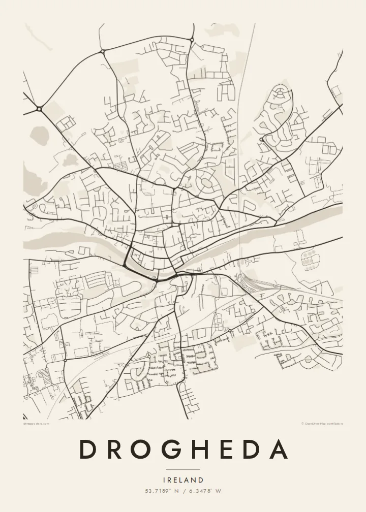
Drogheda stands on the River Boyne a few kilometres upstream from its mouth on the Irish Sea, and the town has grown on both banks, straddling the boundary between counties Louth and Meath. From above, the river cuts a clear line through the centre, with the medieval street pattern gathered along the north bank and the land rising on the south side toward Millmount.
Millmount, a prominent mound topped by a Martello tower, overlooks the town, and parts of the medieval walls survive, most notably St Laurence's Gate, a tall barbican on the eastern side of the old centre. The town was besieged by Oliver Cromwell in 1649, and St Peter's Church holds the preserved head of St Oliver Plunkett.
East of the centre, the Boyne Viaduct carries the Dublin–Belfast railway high above the river, one of the most striking structures on the Irish rail network. Upriver lie Brú na Bóinne and the site of the Battle of the Boyne. A Drogheda map poster frames the river, the viaduct and the old town in a single composition.
Opened in 1855, the railway viaduct spans the Boyne east of the centre, its long straight line crossing the river and the quays below it in a single stroke on the map.
North of the river, the old town keeps a compact pattern of narrow streets and lanes, with St Laurence's Gate marking the line of the former walls.
On the south bank, the mound of Millmount rises above the town with its Martello tower, the high point from which the whole river crossing can be seen.
Agħmlu tiegħek
Żid data, isem jew sentenza tiegħek, ibdel l-istil, id-daqs jew l-orjentazzjoni.
Il-preview b'xejn hija b'riżoluzzjoni baxxa u bil-watermark. L-istampi u l-fajls HD jiġu ġġenerati b'300 DPI, sa 7,200 × 10,800 px, mingħajr watermark.
Għaliex Drogheda
Drogheda is a hometown for many who have moved to Dublin or further afield, and a gateway to the Boyne Valley for visitors. A map of its river, viaduct and old streets is a clear, understated way to keep the town close.
Add a family name or a date to the title and subtitle, adjust the coordinates line, and choose from five styles, including Noir and Blueprint. HD files cost $9 in six sizes, and printed posters ship from partners in more than 30 countries.
Ordna l-poster Drogheda| Daqs tal-istampa | Riżoluzzjoni | Fajls |
|---|---|---|
| 30 × 40 cm (11.8 × 15.7″) | 3,543 × 4,724 px | PNG · PDF |
| 29.7 × 42 cm (A3, 11.7 × 16.5″) | 3,508 × 4,961 px | PNG · PDF |
| 42 × 59.4 cm (A2, 16.5 × 23.4″) | 4,961 × 7,016 px | PNG · PDF |
| 45.7 × 61 cm (18 × 24″) | 5,400 × 7,200 px | PNG · PDF |
| 50 × 70 cm (19.7 × 27.6″) | 5,906 × 8,268 px | PNG · PDF |
| 61 × 91.4 cm (24 × 36″) | 7,200 × 10,800 px | PNG · PDF |
Għal paragun, il-preview b'xejn huwa wiesa' 900 px, għandu watermark u huwa maħsub għall-iskrins. Il-fajls HD għandhom sa 8× ir-riżoluzzjoni f'kull direzzjoni u jiġu stampati b'mod nadif fid-daqs sħiħ tal-poster.
Agħżel stil fin-naħa ta' fuq tal-paġna, imbagħad agħżel Poster Stampat — daqs u, jekk trid, kurniċa — jew Fajls Diġitali HD. Il-ħlas isir f'pass wieħed, u l-paġna tal-ordni tiegħek tiġi aġġornata malli l-ħlas jgħaddi.
Jiġi stampat fuq karta matte premium ta' 200 gsm f'wieħed minn sitt daqsijiet, minn 30 × 40 cm sa 24 × 36″. Il-posters stampati jibdew minn {printFrom}, bil-kunsinna inkluża.
Iva. Agħżel kurniċa tal-injam solidu f'iswed, abjad, ballut naturali jew injam skur. Tiġi bi ħġieġ li ma jinkisirx u lesta biex tittella'. Il-posters inkurnati jibdew minn {framedFrom}, bil-kunsinna inkluża.
Il-kunsinna hija b'xejn madwar id-dinja. Kull poster jiġi stampat mill-eqreb sieħeb tal-istampar tagħna f'aktar minn 30 pajjiż u ġeneralment jasal fi 3–7 ijiem tax-xogħol. Tista' ssegwi l-istatus u t-tracking taħt L-Ordnijiet Tiegħi.
Ibgħatilna ritratt fi żmien 14-il jum mill-kunsinna u aħna nistampawh mill-ġdid b'xejn jew nirrimborżawk.
Iva. Fl-editur ta' din il-paġna, biddel it-titlu, is-sottotitlu u l-linja tal-koordinati għal kwalunkwe ħaġa trid, u agħżel stil u daqs. L-ordnijiet stampati, inkurnati u diġitali kollha jużaw eżattament id-disinn tiegħek.
Għal $9 tikseb fajls PNG b'300 DPI u PDF lesti għall-istampar fis-sitt daqsijiet kollha, mingħajr watermark, biex tistampa kullimkien. Għadek mhux ċert? L-ewwel iddawnlowdja preview b'xejn bil-watermark.
