Hagåtña waist
The capital sits where the island narrows, its compact streets pressed between the bay and a limestone ridge. It marks the natural midpoint of the composition and holds the clearest urban texture on the map.
Poster minimalist tal-mappa · l-Istati Uniti
13.4502° N / 144.7876° E
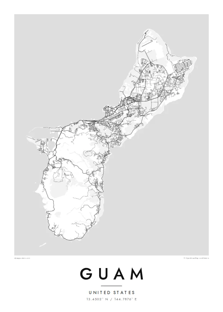
A long, pinched island with a flat limestone north, volcanic southern hills and a harbour carved into its western shore.


Belt waħda, ħames atmosferi
Agħfas fuq stil biex tarah fuq il-ħajt. Kull stil jiswa l-istess — stampat, inkurnat jew bħala fajls HD.
 Pixels reali · fajl tal-istampar 24 × 36″
Preċiż għall-istampar
Dan huwa qtugħ ta' 100% mill-fajl tal-istampar reali. Kull poster — stampat, inkurnat jew iddawnlowdjat — jiġi ġġenerat fuq is-servers tagħna b'300 DPI, sa 7,200 × 10,800 pixel, biex saħansitra l-iżgħar toroq jibqgħu ċari fuq stampa ta' 24 × 36″.
Fuq il-ħajt


Il-mappa
Guam is the largest and southernmost of the Mariana Islands, a United States territory in the western Pacific. From above it reads as a narrow island about fifty kilometres long, drawn in at the middle where the capital, Hagåtña, sits on the western coast. North of that waist lies a raised limestone plateau with long straight roads and large cleared areas. To the south the land folds into ridges and river valleys.
On a Guam map poster the western shoreline carries most of the detail. Marine Corps Drive traces the coast past Tumon Bay, where hotels line a curved sandy beach, and continues south to Apra Harbor, a deep port sheltered by a breakwater and the Orote Peninsula. The eastern side faces the open ocean and is quieter on paper, with scattered villages and fewer roads between the cliffs and the reef.
Chamorro people settled the island thousands of years before European contact, and village names across the map still reflect that heritage. Not far offshore lies the Mariana Trench, whose Challenger Deep is the deepest known point of the ocean floor, though a poster shows only the reef edge and the coast. What remains is a clear portrait of a small island shaped by both volcanic rock and coral.
The capital sits where the island narrows, its compact streets pressed between the bay and a limestone ridge. It marks the natural midpoint of the composition and holds the clearest urban texture on the map.
A wide, sheltered anchorage on the west coast, framed by the Orote Peninsula and a long breakwater. Its hard-edged piers and basins give the southern half of the poster a strong graphic anchor.
Above the waist, the land becomes a flat limestone table crossed by long straight roads and the broad rectangles of airfields, a far more geometric pattern than the winding valleys of the south.
Agħmlu tiegħek
Żid data, isem jew sentenza tiegħek, ibdel l-istil, id-daqs jew l-orjentazzjoni.
Il-preview b'xejn hija b'riżoluzzjoni baxxa u bil-watermark. L-istampi u l-fajls HD jiġu ġġenerati b'300 DPI, sa 7,200 × 10,800 px, mingħajr watermark.
Għaliex Guam
A Guam poster suits people who were stationed on the island, grew up in one of its villages or spent time along Tumon Bay. The outline is compact enough to show whole, so the print works as a complete portrait of the island rather than a cropped fragment of it.
You can change the title, add a subtitle such as a family name or a date, and edit the coordinates line. Choose from five styles, Classic black & white, Noir, Paper, Blueprint or Sand, then take the $9 HD files in six sizes or order a matte print, framed if you prefer.
Ordna l-poster Guam| Daqs tal-istampa | Riżoluzzjoni | Fajls |
|---|---|---|
| 30 × 40 cm (11.8 × 15.7″) | 3,543 × 4,724 px | PNG · PDF |
| 29.7 × 42 cm (A3, 11.7 × 16.5″) | 3,508 × 4,961 px | PNG · PDF |
| 42 × 59.4 cm (A2, 16.5 × 23.4″) | 4,961 × 7,016 px | PNG · PDF |
| 45.7 × 61 cm (18 × 24″) | 5,400 × 7,200 px | PNG · PDF |
| 50 × 70 cm (19.7 × 27.6″) | 5,906 × 8,268 px | PNG · PDF |
| 61 × 91.4 cm (24 × 36″) | 7,200 × 10,800 px | PNG · PDF |
Għal paragun, il-preview b'xejn huwa wiesa' 900 px, għandu watermark u huwa maħsub għall-iskrins. Il-fajls HD għandhom sa 8× ir-riżoluzzjoni f'kull direzzjoni u jiġu stampati b'mod nadif fid-daqs sħiħ tal-poster.
Agħżel stil fin-naħa ta' fuq tal-paġna, imbagħad agħżel Poster Stampat — daqs u, jekk trid, kurniċa — jew Fajls Diġitali HD. Il-ħlas isir f'pass wieħed, u l-paġna tal-ordni tiegħek tiġi aġġornata malli l-ħlas jgħaddi.
Jiġi stampat fuq karta matte premium ta' 200 gsm f'wieħed minn sitt daqsijiet, minn 30 × 40 cm sa 24 × 36″. Il-posters stampati jibdew minn {printFrom}, bil-kunsinna inkluża.
Iva. Agħżel kurniċa tal-injam solidu f'iswed, abjad, ballut naturali jew injam skur. Tiġi bi ħġieġ li ma jinkisirx u lesta biex tittella'. Il-posters inkurnati jibdew minn {framedFrom}, bil-kunsinna inkluża.
L-ispedizzjoni hija b'xejn mad-dinja kollha. Kull poster jiġi stampat mill-eqreb wieħed mis-sieħba tal-istampar tagħna f'aktar minn 30 pajjiż u normalment jaslilek fi 3–7 ijiem tax-xogħol. Tista' tsegwi l-istatus u t-traċċar taħt L-Ordnijiet Tiegħi. Xi pajjiżi jieħdu 2–5 ġimgħat, u fejn għadna ma nispedixxux, is-sit jgħidlek qabel ma tħallas.
Ibgħatilna ritratt fi żmien 14-il jum mill-kunsinna u aħna nistampawh mill-ġdid b'xejn jew nirrimborżawk.
Iva. Fl-editur ta' din il-paġna, biddel it-titlu, is-sottotitlu u l-linja tal-koordinati għal kwalunkwe ħaġa trid, u agħżel stil u daqs. L-ordnijiet stampati, inkurnati u diġitali kollha jużaw eżattament id-disinn tiegħek.
Għal $9 tikseb fajls PNG b'300 DPI u PDF lesti għall-istampar fis-sitt daqsijiet kollha, mingħajr watermark, biex tistampa kullimkien. Għadek mhux ċert? L-ewwel iddawnlowdja preview b'xejn bil-watermark.
