The Nahe valley
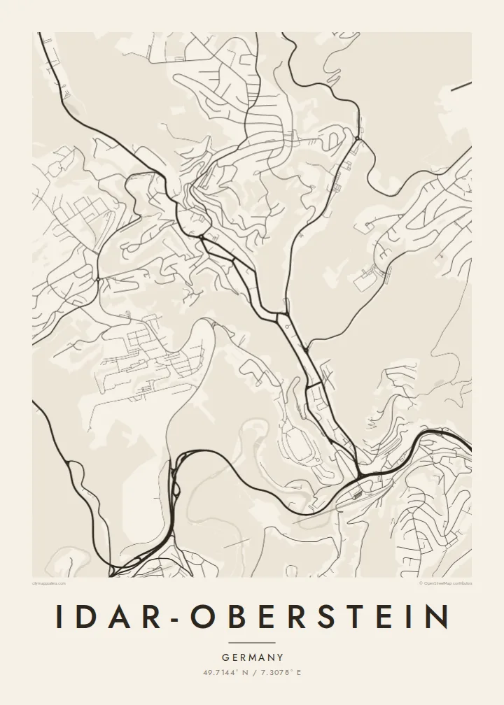
The river bends through a deep valley, and the town lines both banks in a thin continuous strip, giving the map a strong, flowing diagonal from one edge to the other.
Poster minimalist tal-mappa · il-Ġermanja
49.7144° N / 7.3078° E
A long, narrow town threaded through the steep Nahe valley, its streets squeezed between wooded slopes and river




Belt waħda, ħames atmosferi
Agħfas fuq stil biex tarah fuq il-ħajt. Kull stil jiswa l-istess — stampat, inkurnat jew bħala fajls HD.
 Pixels reali · fajl tal-istampar 24 × 36″
Preċiż għall-istampar
Dan huwa qtugħ ta' 100% mill-fajl tal-istampar reali. Kull poster — stampat, inkurnat jew iddawnlowdjat — jiġi ġġenerat fuq is-servers tagħna b'300 DPI, sa 7,200 × 10,800 pixel, biex saħansitra l-iżgħar toroq jibqgħu ċari fuq stampa ta' 24 × 36″.
Fuq il-ħajt


Il-mappa
Idar-Oberstein stretches along the valley of the Nahe in the Hunsrück uplands of Rhineland-Palatinate, and its map looks more like a ribbon than a circle. The town follows the river for several kilometres, with steep, forested hillsides pressing in from both sides. Side valleys, including that of the Idarbach, branch off to the north and carry their own lines of houses and roads.
The present town was formed in 1933 by joining Idar and Oberstein, along with neighbouring communities, which explains its elongated shape and its several distinct centres. In the middle of town the main road runs directly above the Nahe for a stretch, so the river partly disappears from view at street level, a detail that makes the valley floor look unusually crowded on the map.
Idar-Oberstein is known across Europe as a centre of gemstone and agate cutting, a craft rooted in local deposits and later sustained by imported stones. Above Oberstein, the Felsenkirche, a church built into a rock face, overlooks the valley. An Idar-Oberstein map poster records how a town of stone-cutters fitted itself into a narrow, winding river valley.
The river bends through a deep valley, and the town lines both banks in a thin continuous strip, giving the map a strong, flowing diagonal from one edge to the other.
In the centre, the main road is built over the Nahe for a section of its course, so the river line vanishes beneath traffic, an unusual feature in any German town plan.
Tributary valleys such as the Idarbach open off the main valley, each carrying a finger of streets uphill and giving the town its branching, tree-like outline.
Agħmlu tiegħek
Żid data, isem jew sentenza tiegħek, ibdel l-istil, id-daqs jew l-orjentazzjoni.
Il-preview b'xejn hija b'riżoluzzjoni baxxa u bil-watermark. L-istampi u l-fajls HD jiġu ġġenerati b'300 DPI, sa 7,200 × 10,800 px, mingħajr watermark.
Għaliex Idar-Oberstein
The narrow valley shape makes Idar-Oberstein a distinctive map to frame, and it carries meaning for people with ties to the gemstone trade, the Hunsrück or the soldiers and families who have lived nearby. It reads as both a place portrait and a study of landscape.
Personalise the title, subtitle and coordinates line with a name or a date, and choose Classic black and white, Noir, Paper, Blueprint or Sand. The $9 digital files include six sizes as 300 DPI PNG and print-ready PDF, without a watermark. Printed and framed posters are also available.
Ordna l-poster Idar-Oberstein| Daqs tal-istampa | Riżoluzzjoni | Fajls |
|---|---|---|
| 30 × 40 cm11.8 × 15.7″ | 3,543 × 4,724 px | PNG · PDF |
| 29.7 × 42 cm (A3)11.7 × 16.5″ | 3,508 × 4,961 px | PNG · PDF |
| 42 × 59.4 cm (A2)16.5 × 23.4″ | 4,961 × 7,016 px | PNG · PDF |
| 45.7 × 61 cm18 × 24″ | 5,400 × 7,200 px | PNG · PDF |
| 50 × 70 cm19.7 × 27.6″ | 5,906 × 8,268 px | PNG · PDF |
| 61 × 91.4 cm24 × 36″ | 7,200 × 10,800 px | PNG · PDF |
Għal paragun, il-preview b'xejn huwa wiesa' 900 px, għandu watermark u huwa maħsub għall-iskrins. Il-fajls HD għandhom sa 8× ir-riżoluzzjoni f'kull direzzjoni u jiġu stampati b'mod nadif fid-daqs sħiħ tal-poster.
Agħżel stil fin-naħa ta' fuq tal-paġna, imbagħad agħżel Poster Stampat — daqs u, jekk trid, kurniċa — jew Fajls Diġitali HD. Il-ħlas isir f'pass wieħed, u l-paġna tal-ordni tiegħek tiġi aġġornata malli l-ħlas jgħaddi.
Jiġi stampat fuq karta matte premium ta' 200 gsm f'wieħed minn sitt daqsijiet, minn 30 × 40 cm sa 24 × 36″. Il-posters stampati jibdew minn $39, bil-kunsinna inkluża.
Iva. Agħżel kurniċa tal-injam solidu f'iswed, abjad, ballut naturali jew injam skur. Tiġi bi ħġieġ li ma jinkisirx u lesta biex tittella'. Il-posters inkurnati jibdew minn $99, bil-kunsinna inkluża.
It-tbaħħir huwa b'xejn lejn 60+ pajjiż. Kull poster jiġi stampat mill-eqreb wieħed mis-sieħba tal-istampar tagħna f'30+ pajjiż u normalment jaslek fi 3–7 ijiem tax-xogħol. Tista' ssegwi l-istatus u t-traċċar taħt L-Ordnijiet Tiegħi. Xi pajjiżi jieħdu 2–5 ġimgħat, u fejn għadna ma nibagħtux, is-sit jgħidlek qabel tħallas.
Ibgħatilna ritratt fi żmien 14-il jum mill-kunsinna u aħna nistampawh mill-ġdid b'xejn jew nirrimborżawk.
Iva. Fl-editur ta' din il-paġna, biddel it-titlu, is-sottotitlu u l-linja tal-koordinati għal kwalunkwe ħaġa trid, u agħżel stil u daqs. L-ordnijiet stampati, inkurnati u diġitali kollha jużaw eżattament id-disinn tiegħek.
Għal $9 tikseb fajls PNG b'300 DPI u PDF lesti għall-istampar fis-sitt daqsijiet kollha, mingħajr watermark, biex tistampa kullimkien. Għadek mhux ċert? L-ewwel iddawnlowdja preview b'xejn bil-watermark.
