Danube frontage
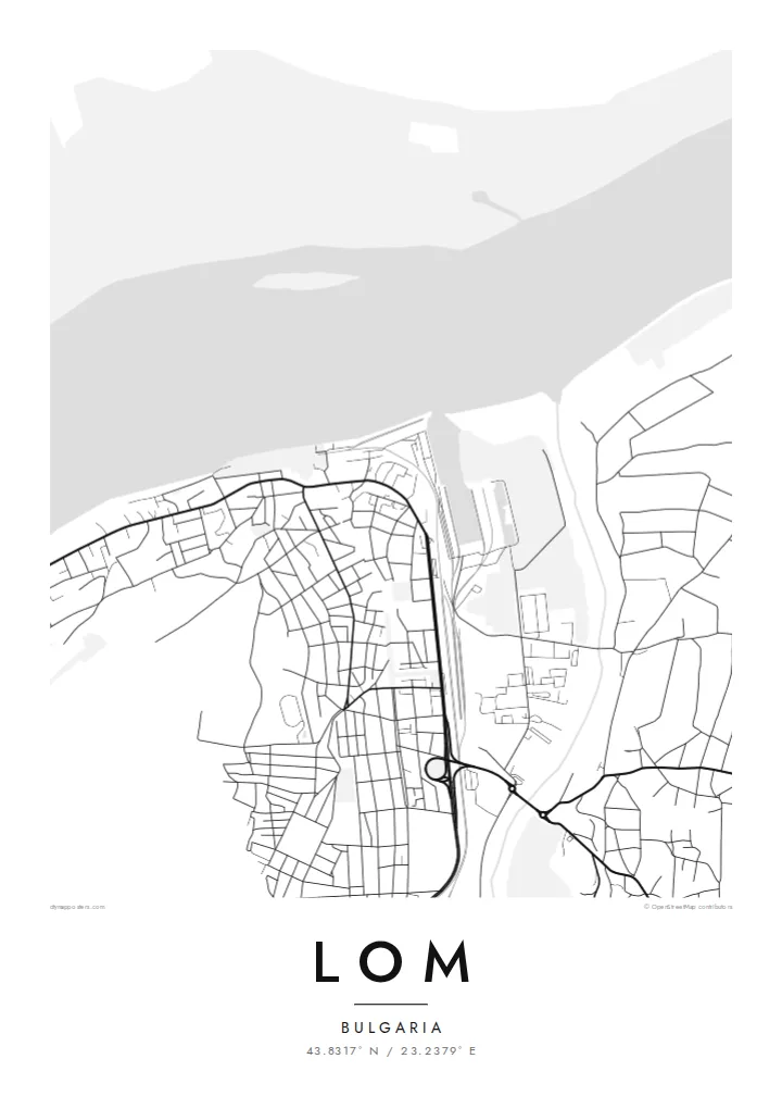
The wide river runs along the whole northern edge of the town, its shoreline and islands giving the map a strong horizontal line.
Poster minimalist tal-mappa · il-Bulgarija
43.8317° N / 23.2379° E
A Danube river port in north-western Bulgaria, where the town's streets meet the wide river at the mouth of the Lom.


Belt waħda, ħames atmosferi
Agħfas fuq stil biex tarah fuq il-ħajt. Kull stil jiswa l-istess — stampat, inkurnat jew bħala fajls HD.
 Pixels reali · fajl tal-istampar 24 × 36″
Preċiż għall-istampar
Dan huwa qtugħ ta' 100% mill-fajl tal-istampar reali. Kull poster — stampat, inkurnat jew iddawnlowdjat — jiġi ġġenerat fuq is-servers tagħna b'300 DPI, sa 7,200 × 10,800 pixel, biex saħansitra l-iżgħar toroq jibqgħu ċari fuq stampa ta' 24 × 36″.
Fuq il-ħajt


Il-mappa
Lom sits on the right bank of the Danube in north-western Bulgaria, at the point where the smaller river Lom flows into it. The Danube here is broad and marks the border with Romania, and on a map the town is defined by this long stretch of water. Streets run up from the riverfront onto higher ground, forming a compact grid behind the port.
The site has a long past. In Roman times a fortress called Almus stood here, guarding the Danube frontier, and the town later grew into one of Bulgaria's principal river ports. Quays still take up much of the waterfront, and the river islands and floodplain opposite appear as broad, irregular shapes on the far side of the channel.
A Lom map poster is essentially a portrait of the Danube: the long sweep of the river, the smaller tributary joining it, and a town arranged to face the water. It is a natural choice for people with family ties to north-western Bulgaria, and for anyone who has travelled along the lower Danube.
The wide river runs along the whole northern edge of the town, its shoreline and islands giving the map a strong horizontal line.
The small river Lom meets the Danube at the edge of town, a short curving line that joins the main channel and gives the town its name.
Behind the port the streets form a fairly regular pattern of blocks, rising gently from the water and ending at the fields beyond.
Agħmlu tiegħek
Żid data, isem jew sentenza tiegħek, ibdel l-istil, id-daqs jew l-orjentazzjoni.
Il-preview b'xejn hija b'riżoluzzjoni baxxa u bil-watermark. L-istampi u l-fajls HD jiġu ġġenerati b'300 DPI, sa 7,200 × 10,800 px, mingħajr watermark.
Għaliex Lom
Lom's identity is tied to the river, and a map shows that at a glance. It suits people who grew up in the town, relatives living elsewhere in Europe, and travellers who remember the Danube and the view from the waterfront.
Add your own title, subtitle and coordinates line and choose between Classic black & white, Noir, Paper, Blueprint and Sand. The $9 HD files arrive as 300 DPI PNG and print-ready PDF, and printed posters ship from partners in more than 30 countries.
Ordna l-poster Lom| Daqs tal-istampa | Riżoluzzjoni | Fajls |
|---|---|---|
| 30 × 40 cm (11.8 × 15.7″) | 3,543 × 4,724 px | PNG · PDF |
| 29.7 × 42 cm (A3, 11.7 × 16.5″) | 3,508 × 4,961 px | PNG · PDF |
| 42 × 59.4 cm (A2, 16.5 × 23.4″) | 4,961 × 7,016 px | PNG · PDF |
| 45.7 × 61 cm (18 × 24″) | 5,400 × 7,200 px | PNG · PDF |
| 50 × 70 cm (19.7 × 27.6″) | 5,906 × 8,268 px | PNG · PDF |
| 61 × 91.4 cm (24 × 36″) | 7,200 × 10,800 px | PNG · PDF |
Għal paragun, il-preview b'xejn huwa wiesa' 900 px, għandu watermark u huwa maħsub għall-iskrins. Il-fajls HD għandhom sa 8× ir-riżoluzzjoni f'kull direzzjoni u jiġu stampati b'mod nadif fid-daqs sħiħ tal-poster.
Agħżel stil fin-naħa ta' fuq tal-paġna, imbagħad agħżel Poster Stampat — daqs u, jekk trid, kurniċa — jew Fajls Diġitali HD. Il-ħlas isir f'pass wieħed, u l-paġna tal-ordni tiegħek tiġi aġġornata malli l-ħlas jgħaddi.
Jiġi stampat fuq karta matte premium ta' 200 gsm f'wieħed minn sitt daqsijiet, minn 30 × 40 cm sa 24 × 36″. Il-posters stampati jibdew minn {printFrom}, bil-kunsinna inkluża.
Iva. Agħżel kurniċa tal-injam solidu f'iswed, abjad, ballut naturali jew injam skur. Tiġi bi ħġieġ li ma jinkisirx u lesta biex tittella'. Il-posters inkurnati jibdew minn {framedFrom}, bil-kunsinna inkluża.
L-ispedizzjoni hija b'xejn mad-dinja kollha. Kull poster jiġi stampat mill-eqreb wieħed mis-sieħba tal-istampar tagħna f'aktar minn 30 pajjiż u normalment jaslilek fi 3–7 ijiem tax-xogħol. Tista' tsegwi l-istatus u t-traċċar taħt L-Ordnijiet Tiegħi. Xi pajjiżi jieħdu 2–5 ġimgħat, u fejn għadna ma nispedixxux, is-sit jgħidlek qabel ma tħallas.
Ibgħatilna ritratt fi żmien 14-il jum mill-kunsinna u aħna nistampawh mill-ġdid b'xejn jew nirrimborżawk.
Iva. Fl-editur ta' din il-paġna, biddel it-titlu, is-sottotitlu u l-linja tal-koordinati għal kwalunkwe ħaġa trid, u agħżel stil u daqs. L-ordnijiet stampati, inkurnati u diġitali kollha jużaw eżattament id-disinn tiegħek.
Għal $9 tikseb fajls PNG b'300 DPI u PDF lesti għall-istampar fis-sitt daqsijiet kollha, mingħajr watermark, biex tistampa kullimkien. Għadek mhux ċert? L-ewwel iddawnlowdja preview b'xejn bil-watermark.
