Railway line
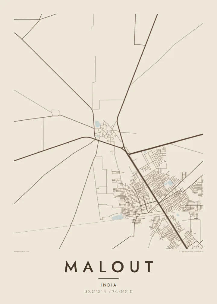
The railway crosses the town in a straight line. Much of the older built area grew up along it, and it gives the map a clear central axis.
Poster minimalist tal-mappa · l-Indja
30.2112° N / 74.4818° E
A flat market town on the plains of south-western Punjab, gathered around its railway and surrounded by irrigated farmland


Belt waħda, ħames atmosferi
Agħfas fuq stil biex tarah fuq il-ħajt. Kull stil jiswa l-istess — stampat, inkurnat jew bħala fajls HD.
 Pixels reali · fajl tal-istampar 24 × 36″
Preċiż għall-istampar
Dan huwa qtugħ ta' 100% mill-fajl tal-istampar reali. Kull poster — stampat, inkurnat jew iddawnlowdjat — jiġi ġġenerat fuq is-servers tagħna b'300 DPI, sa 7,200 × 10,800 pixel, biex saħansitra l-iżgħar toroq jibqgħu ċari fuq stampa ta' 24 × 36″.
Fuq il-ħajt


Il-mappa
Malout sits on the level plains of the Malwa region, in the Sri Muktsar Sahib district of Punjab. With no hills or major rivers to shape it, the town has grown outward along its roads and railway, and its map is compact and clearly bounded. Beyond the last houses there is a wide spread of fields, with irrigation channels and farm tracks running across them.
The town is an agricultural centre, and its grain market handles produce from the surrounding countryside, where wheat, cotton and rice are major crops. Malout lies close to the borders with Haryana and Rajasthan, so it has long served as a meeting point for trade across state lines.
A Malout map poster records a town defined by the plains. The dense centre gives way to looser housing, the railway runs as a steady straight line, and the farmland around it is drawn almost empty. It is a restrained and honest image of a place built around agriculture.
The railway crosses the town in a straight line. Much of the older built area grew up along it, and it gives the map a clear central axis.
The oldest and busiest streets gather around the market area. They form the densest cluster of lines on the map.
Around the town, irrigation channels and field boundaries cross the flat land. From above they draw a faint geometric pattern.
Agħmlu tiegħek
Żid data, isem jew sentenza tiegħek, ibdel l-istil, id-daqs jew l-orjentazzjoni.
Il-preview b'xejn hija b'riżoluzzjoni baxxa u bil-watermark. L-istampi u l-fajls HD jiġu ġġenerati b'300 DPI, sa 7,200 × 10,800 px, mingħajr watermark.
Għaliex Malout
Families from Malout who now live in other Indian cities or abroad often want something that shows exactly where home is. A clean map of the town does that without needing any explanation.
Write a title in your own words, add a subtitle such as a family name or a year, and choose from Classic black & white, Noir, Paper, Blueprint or Sand. Download the HD files once and print them anywhere, or order a finished poster.
Ordna l-poster Malout| Daqs tal-istampa | Riżoluzzjoni | Fajls |
|---|---|---|
| 30 × 40 cm (11.8 × 15.7″) | 3,543 × 4,724 px | PNG · PDF |
| 29.7 × 42 cm (A3, 11.7 × 16.5″) | 3,508 × 4,961 px | PNG · PDF |
| 42 × 59.4 cm (A2, 16.5 × 23.4″) | 4,961 × 7,016 px | PNG · PDF |
| 45.7 × 61 cm (18 × 24″) | 5,400 × 7,200 px | PNG · PDF |
| 50 × 70 cm (19.7 × 27.6″) | 5,906 × 8,268 px | PNG · PDF |
| 61 × 91.4 cm (24 × 36″) | 7,200 × 10,800 px | PNG · PDF |
Għal paragun, il-preview b'xejn huwa wiesa' 900 px, għandu watermark u huwa maħsub għall-iskrins. Il-fajls HD għandhom sa 8× ir-riżoluzzjoni f'kull direzzjoni u jiġu stampati b'mod nadif fid-daqs sħiħ tal-poster.
Agħżel stil fin-naħa ta' fuq tal-paġna, imbagħad agħżel Poster Stampat — daqs u, jekk trid, kurniċa — jew Fajls Diġitali HD. Il-ħlas isir f'pass wieħed, u l-paġna tal-ordni tiegħek tiġi aġġornata malli l-ħlas jgħaddi.
Jiġi stampat fuq karta matte premium ta' 200 gsm f'wieħed minn sitt daqsijiet, minn 30 × 40 cm sa 24 × 36″. Il-posters stampati jibdew minn {printFrom}, bil-kunsinna inkluża.
Iva. Agħżel kurniċa tal-injam solidu f'iswed, abjad, ballut naturali jew injam skur. Tiġi bi ħġieġ li ma jinkisirx u lesta biex tittella'. Il-posters inkurnati jibdew minn {framedFrom}, bil-kunsinna inkluża.
Il-kunsinna hija b'xejn madwar id-dinja. Kull poster jiġi stampat mill-eqreb sieħeb tal-istampar tagħna f'aktar minn 30 pajjiż u ġeneralment jasal fi 3–7 ijiem tax-xogħol. Tista' ssegwi l-istatus u t-tracking taħt L-Ordnijiet Tiegħi.
Ibgħatilna ritratt fi żmien 14-il jum mill-kunsinna u aħna nistampawh mill-ġdid b'xejn jew nirrimborżawk.
Iva. Fl-editur ta' din il-paġna, biddel it-titlu, is-sottotitlu u l-linja tal-koordinati għal kwalunkwe ħaġa trid, u agħżel stil u daqs. L-ordnijiet stampati, inkurnati u diġitali kollha jużaw eżattament id-disinn tiegħek.
Għal $9 tikseb fajls PNG b'300 DPI u PDF lesti għall-istampar fis-sitt daqsijiet kollha, mingħajr watermark, biex tistampa kullimkien. Għadek mhux ċert? L-ewwel iddawnlowdja preview b'xejn bil-watermark.
