Mohokare River
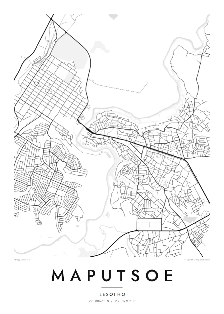
The Mohokare, or Caledon, meanders along the edge of Maputsoe and marks the border with South Africa. It gives the map its most fluid and distinctive line.
Poster minimalist tal-mappa · il-Lesoto
28.8866° S / 27.8991° E
A Lesotho border town on the Mohokare River, facing Ficksburg across a single bridge and busy border crossing.


Belt waħda, ħames atmosferi
Agħfas fuq stil biex tarah fuq il-ħajt. Kull stil jiswa l-istess — stampat, inkurnat jew bħala fajls HD.
 Pixels reali · fajl tal-istampar 24 × 36″
Preċiż għall-istampar
Dan huwa qtugħ ta' 100% mill-fajl tal-istampar reali. Kull poster — stampat, inkurnat jew iddawnlowdjat — jiġi ġġenerat fuq is-servers tagħna b'300 DPI, sa 7,200 × 10,800 pixel, biex saħansitra l-iżgħar toroq jibqgħu ċari fuq stampa ta' 24 × 36″.
Fuq il-ħajt


Il-mappa
Maputsoe lies in Leribe District in northern Lesotho, right on the Mohokare River, which South Africa calls the Caledon. The river forms the international border here, and on the map it runs as a winding line along the town's western edge. Across the water lies Ficksburg in the Free State. The two towns are joined by the Maputsoe Bridge crossing, one of the main gateways into Lesotho.
That position has shaped the town. Maputsoe grew as a trading and transit point, and since the late twentieth century it has become an industrial centre, with textile and garment factories set in industrial areas near the border. On the map, these large factory blocks sit beside dense residential neighbourhoods that climb gently eastwards, away from the river, towards the foothills.
A Maputsoe map poster captures a town defined by a border. The Mohokare curves along one side, the bridge crossing ties it to its neighbour, and the streets spread inland across rising ground. It is a compact, readable composition with a strong natural line and a clear story.
The Mohokare, or Caledon, meanders along the edge of Maputsoe and marks the border with South Africa. It gives the map its most fluid and distinctive line.
The road crossing to Ficksburg is the town's link to South Africa. On the map it is a short but significant connection over the river.
Industrial areas with large, regular buildings sit near the crossing. They contrast with the smaller, irregular plots of the residential areas further east.
Agħmlu tiegħek
Żid data, isem jew sentenza tiegħek, ibdel l-istil, id-daqs jew l-orjentazzjoni.
Il-preview b'xejn hija b'riżoluzzjoni baxxa u bil-watermark. L-istampi u l-fajls HD jiġu ġġenerati b'300 DPI, sa 7,200 × 10,800 px, mingħajr watermark.
Għaliex Maputsoe
A map of Maputsoe means a lot to those who live, work or grew up in this border town, and to families on both sides of the river. It records a very particular place, a town shaped by a river and a crossing.
Personalise it with a title, a subtitle such as a date or family name, and a coordinates line. Then pick one of five styles, Classic black & white, Noir, Paper, Blueprint or Sand, to match your space.
Ordna l-poster Maputsoe| Daqs tal-istampa | Riżoluzzjoni | Fajls |
|---|---|---|
| 30 × 40 cm (11.8 × 15.7″) | 3,543 × 4,724 px | PNG · PDF |
| 29.7 × 42 cm (A3, 11.7 × 16.5″) | 3,508 × 4,961 px | PNG · PDF |
| 42 × 59.4 cm (A2, 16.5 × 23.4″) | 4,961 × 7,016 px | PNG · PDF |
| 45.7 × 61 cm (18 × 24″) | 5,400 × 7,200 px | PNG · PDF |
| 50 × 70 cm (19.7 × 27.6″) | 5,906 × 8,268 px | PNG · PDF |
| 61 × 91.4 cm (24 × 36″) | 7,200 × 10,800 px | PNG · PDF |
Għal paragun, il-preview b'xejn huwa wiesa' 900 px, għandu watermark u huwa maħsub għall-iskrins. Il-fajls HD għandhom sa 8× ir-riżoluzzjoni f'kull direzzjoni u jiġu stampati b'mod nadif fid-daqs sħiħ tal-poster.
Agħżel stil fin-naħa ta' fuq tal-paġna, imbagħad agħżel Poster Stampat — daqs u, jekk trid, kurniċa — jew Fajls Diġitali HD. Il-ħlas isir f'pass wieħed, u l-paġna tal-ordni tiegħek tiġi aġġornata malli l-ħlas jgħaddi.
Jiġi stampat fuq karta matte premium ta' 200 gsm f'wieħed minn sitt daqsijiet, minn 30 × 40 cm sa 24 × 36″. Il-posters stampati jibdew minn {printFrom}, bil-kunsinna inkluża.
Iva. Agħżel kurniċa tal-injam solidu f'iswed, abjad, ballut naturali jew injam skur. Tiġi bi ħġieġ li ma jinkisirx u lesta biex tittella'. Il-posters inkurnati jibdew minn {framedFrom}, bil-kunsinna inkluża.
Il-kunsinna hija b'xejn madwar id-dinja. Kull poster jiġi stampat mill-eqreb sieħeb tal-istampar tagħna f'aktar minn 30 pajjiż u ġeneralment jasal fi 3–7 ijiem tax-xogħol. Tista' ssegwi l-istatus u t-tracking taħt L-Ordnijiet Tiegħi.
Ibgħatilna ritratt fi żmien 14-il jum mill-kunsinna u aħna nistampawh mill-ġdid b'xejn jew nirrimborżawk.
Iva. Fl-editur ta' din il-paġna, biddel it-titlu, is-sottotitlu u l-linja tal-koordinati għal kwalunkwe ħaġa trid, u agħżel stil u daqs. L-ordnijiet stampati, inkurnati u diġitali kollha jużaw eżattament id-disinn tiegħek.
Għal $9 tikseb fajls PNG b'300 DPI u PDF lesti għall-istampar fis-sitt daqsijiet kollha, mingħajr watermark, biex tistampa kullimkien. Għadek mhux ċert? L-ewwel iddawnlowdja preview b'xejn bil-watermark.
