The Albert Canal
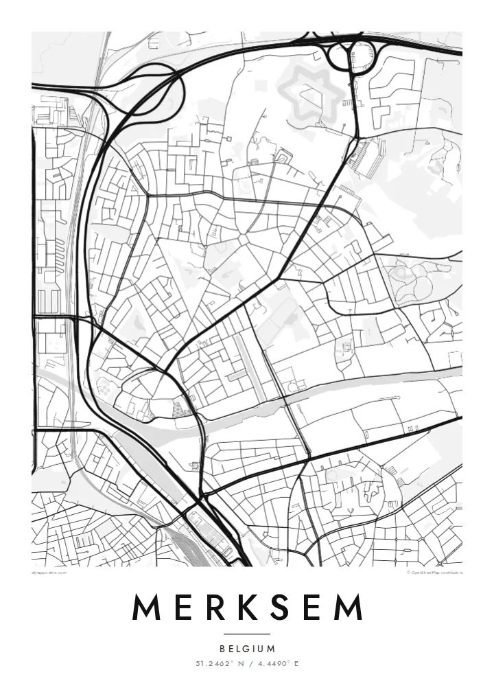
The canal runs straight along the southern edge of Merksem, separating it from central Antwerp and crossed by a series of bridges.
Poster minimalist tal-mappa · il-Belġju
51.2462° N / 4.4490° E
Antwerp's northern district, bounded by the Albert Canal and threaded with dense residential streets and major roads


Belt waħda, ħames atmosferi
Agħfas fuq stil biex tarah fuq il-ħajt. Kull stil jiswa l-istess — stampat, inkurnat jew bħala fajls HD.
 Pixels reali · fajl tal-istampar 24 × 36″
Preċiż għall-istampar
Dan huwa qtugħ ta' 100% mill-fajl tal-istampar reali. Kull poster — stampat, inkurnat jew iddawnlowdjat — jiġi ġġenerat fuq is-servers tagħna b'300 DPI, sa 7,200 × 10,800 pixel, biex saħansitra l-iżgħar toroq jibqgħu ċari fuq stampa ta' 24 × 36″.
Fuq il-ħajt


Il-mappa
Merksem is a district on the northern side of Antwerp, just beyond the Albert Canal. On a map, the canal forms a strong, straight southern edge, with bridges connecting the district to the city centre. North of the water, rows of terraced housing make a close-knit street pattern, and wide roads and the motorway ring cut through it.
Merksem was an independent municipality until 1983, when it merged into the city of Antwerp. It still keeps a separate identity, with its own centre, churches and local streets. The port of Antwerp lies to the west, and its industrial scale sits close to Merksem's quieter residential blocks.
A Merksem map poster shows the meeting of neighbourhood and infrastructure. The canal, the ring road and the rail lines give the map strong structural lines. In between are the smaller streets where people live. It is a portrait of a place that belongs to a large city but has never quite blended into it.
The canal runs straight along the southern edge of Merksem, separating it from central Antwerp and crossed by a series of bridges.
Dense rows of houses fill the district in a tight pattern of short streets, typical of Antwerp's northern neighbourhoods.
Major road links pass through and around the district and draw broad lines that contrast with the finer residential streets.
Agħmlu tiegħek
Żid data, isem jew sentenza tiegħek, ibdel l-istil, id-daqs jew l-orjentazzjoni.
Il-preview b'xejn hija b'riżoluzzjoni baxxa u bil-watermark. L-istampi u l-fajls HD jiġu ġġenerati b'300 DPI, sa 7,200 × 10,800 px, mingħajr watermark.
Għaliex Merksem
Merksem is hung by people who grew up there, who moved away from Antwerp or who simply feel more at home north of the canal. The mix of canal, roads and houses makes a map with a lot of structure.
You can set the title, subtitle and coordinates line to mark a street, a family or a moving-in date. Five styles are available: Classic black & white, Noir, Paper, Blueprint and Sand.
Ordna l-poster Merksem| Daqs tal-istampa | Riżoluzzjoni | Fajls |
|---|---|---|
| 30 × 40 cm11.8 × 15.7″ | 3,543 × 4,724 px | PNG · PDF |
| 29.7 × 42 cm (A3)11.7 × 16.5″ | 3,508 × 4,961 px | PNG · PDF |
| 42 × 59.4 cm (A2)16.5 × 23.4″ | 4,961 × 7,016 px | PNG · PDF |
| 45.7 × 61 cm18 × 24″ | 5,400 × 7,200 px | PNG · PDF |
| 50 × 70 cm19.7 × 27.6″ | 5,906 × 8,268 px | PNG · PDF |
| 61 × 91.4 cm24 × 36″ | 7,200 × 10,800 px | PNG · PDF |
Għal paragun, il-preview b'xejn huwa wiesa' 900 px, għandu watermark u huwa maħsub għall-iskrins. Il-fajls HD għandhom sa 8× ir-riżoluzzjoni f'kull direzzjoni u jiġu stampati b'mod nadif fid-daqs sħiħ tal-poster.
Agħżel stil fin-naħa ta' fuq tal-paġna, imbagħad agħżel Poster Stampat — daqs u, jekk trid, kurniċa — jew Fajls Diġitali HD. Il-ħlas isir f'pass wieħed, u l-paġna tal-ordni tiegħek tiġi aġġornata malli l-ħlas jgħaddi.
Jiġi stampat fuq karta matte premium ta' 200 gsm f'wieħed minn sitt daqsijiet, minn 30 × 40 cm sa 24 × 36″. Il-posters stampati jibdew minn $39, bil-kunsinna inkluża.
Iva. Agħżel kurniċa tal-injam solidu f'iswed, abjad, ballut naturali jew injam skur. Tiġi bi ħġieġ li ma jinkisirx u lesta biex tittella'. Il-posters inkurnati jibdew minn $99, bil-kunsinna inkluża.
It-tbaħħir huwa b'xejn lejn 60+ pajjiż. Kull poster jiġi stampat mill-eqreb wieħed mis-sieħba tal-istampar tagħna f'30+ pajjiż u normalment jaslek fi 3–7 ijiem tax-xogħol. Tista' ssegwi l-istatus u t-traċċar taħt L-Ordnijiet Tiegħi. Xi pajjiżi jieħdu 2–5 ġimgħat, u fejn għadna ma nibagħtux, is-sit jgħidlek qabel tħallas.
Ibgħatilna ritratt fi żmien 14-il jum mill-kunsinna u aħna nistampawh mill-ġdid b'xejn jew nirrimborżawk.
Iva. Fl-editur ta' din il-paġna, biddel it-titlu, is-sottotitlu u l-linja tal-koordinati għal kwalunkwe ħaġa trid, u agħżel stil u daqs. L-ordnijiet stampati, inkurnati u diġitali kollha jużaw eżattament id-disinn tiegħek.
Għal $9 tikseb fajls PNG b'300 DPI u PDF lesti għall-istampar fis-sitt daqsijiet kollha, mingħajr watermark, biex tistampa kullimkien. Għadek mhux ċert? L-ewwel iddawnlowdja preview b'xejn bil-watermark.
