The sheltered bay
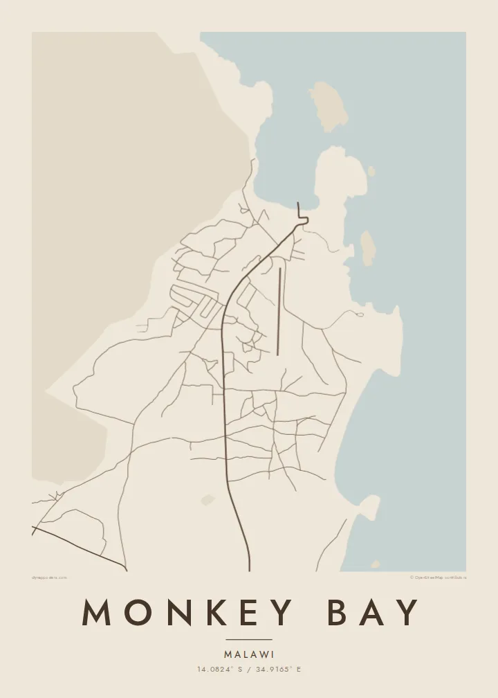
The town wraps around a curved inlet of Lake Malawi, protected from the open lake. This bay shape gives the poster its main outline and a strong, recognisable composition.
Poster minimalist tal-mappa · il-Malawi
14.0824° S / 34.9165° E
A lakeside town on the southern shore of Lake Malawi, beside a sheltered bay and the peninsula leading to Cape Maclear


Belt waħda, ħames atmosferi
Agħfas fuq stil biex tarah fuq il-ħajt. Kull stil jiswa l-istess — stampat, inkurnat jew bħala fajls HD.
 Pixels reali · fajl tal-istampar 24 × 36″
Preċiż għall-istampar
Dan huwa qtugħ ta' 100% mill-fajl tal-istampar reali. Kull poster — stampat, inkurnat jew iddawnlowdjat — jiġi ġġenerat fuq is-servers tagħna b'300 DPI, sa 7,200 × 10,800 pixel, biex saħansitra l-iżgħar toroq jibqgħu ċari fuq stampa ta' 24 × 36″.
Fuq il-ħajt


Il-mappa
Monkey Bay lies at the southern end of Lake Malawi, on the peninsula that reaches out toward Cape Maclear. The town curves around a sheltered bay, with hills rising behind the shoreline and the open water of the lake stretching north. On a map the coastline dominates, and the settlement appears as a band of streets and houses following the shape of the bay.
The town is a working lake port. It is the home base of the MV Ilala, the long-serving passenger ferry that travels up the lake, and it hosts a base of the Malawian navy's lake fleet. A short distance away, Cape Maclear lies within Lake Malawi National Park, a UNESCO World Heritage Site known for its many species of cichlid fish.
A Monkey Bay map poster is really a portrait of shoreline. The curve of the bay, the rocky headlands and the hills behind the town give the map a strong natural outline, while the streets and harbour add a small, human scale. In black and white the lake becomes a wide, calm space against which the town is clearly drawn.
The town wraps around a curved inlet of Lake Malawi, protected from the open lake. This bay shape gives the poster its main outline and a strong, recognisable composition.
Monkey Bay's port, home of the MV Ilala, appears as a small cluster of piers and buildings along the shore, marking the point where the town meets the water.
Beyond the town, the land stretches out into a hilly peninsula toward Cape Maclear and the national park, with a rugged coastline of bays and headlands.
Agħmlu tiegħek
Żid data, isem jew sentenza tiegħek, ibdel l-istil, id-daqs jew l-orjentazzjoni.
Il-preview b'xejn hija b'riżoluzzjoni baxxa u bil-watermark. L-istampi u l-fajls HD jiġu ġġenerati b'300 DPI, sa 7,200 × 10,800 px, mingħajr watermark.
Għaliex Monkey Bay
Monkey Bay is a starting point for journeys on Lake Malawi and to Cape Maclear. The map suits travellers who crossed the lake on the Ilala, volunteers who lived nearby, and anyone who grew up on this stretch of shore.
Personalise the title, subtitle and coordinates to mark a journey or a year, and choose Classic black & white, Noir, Paper, Blueprint or Sand. Files are $9 for six print sizes, or a printed poster ships from partners in 30+ countries.
Ordna l-poster Monkey Bay| Daqs tal-istampa | Riżoluzzjoni | Fajls |
|---|---|---|
| 30 × 40 cm (11.8 × 15.7″) | 3,543 × 4,724 px | PNG · PDF |
| 29.7 × 42 cm (A3, 11.7 × 16.5″) | 3,508 × 4,961 px | PNG · PDF |
| 42 × 59.4 cm (A2, 16.5 × 23.4″) | 4,961 × 7,016 px | PNG · PDF |
| 45.7 × 61 cm (18 × 24″) | 5,400 × 7,200 px | PNG · PDF |
| 50 × 70 cm (19.7 × 27.6″) | 5,906 × 8,268 px | PNG · PDF |
| 61 × 91.4 cm (24 × 36″) | 7,200 × 10,800 px | PNG · PDF |
Għal paragun, il-preview b'xejn huwa wiesa' 900 px, għandu watermark u huwa maħsub għall-iskrins. Il-fajls HD għandhom sa 8× ir-riżoluzzjoni f'kull direzzjoni u jiġu stampati b'mod nadif fid-daqs sħiħ tal-poster.
Agħżel stil fin-naħa ta' fuq tal-paġna, imbagħad agħżel Poster Stampat — daqs u, jekk trid, kurniċa — jew Fajls Diġitali HD. Il-ħlas isir f'pass wieħed, u l-paġna tal-ordni tiegħek tiġi aġġornata malli l-ħlas jgħaddi.
Jiġi stampat fuq karta matte premium ta' 200 gsm f'wieħed minn sitt daqsijiet, minn 30 × 40 cm sa 24 × 36″. Il-posters stampati jibdew minn {printFrom}, bil-kunsinna inkluża.
Iva. Agħżel kurniċa tal-injam solidu f'iswed, abjad, ballut naturali jew injam skur. Tiġi bi ħġieġ li ma jinkisirx u lesta biex tittella'. Il-posters inkurnati jibdew minn {framedFrom}, bil-kunsinna inkluża.
Il-kunsinna hija b'xejn madwar id-dinja. Kull poster jiġi stampat mill-eqreb sieħeb tal-istampar tagħna f'aktar minn 30 pajjiż u ġeneralment jasal fi 3–7 ijiem tax-xogħol. Tista' ssegwi l-istatus u t-tracking taħt L-Ordnijiet Tiegħi.
Ibgħatilna ritratt fi żmien 14-il jum mill-kunsinna u aħna nistampawh mill-ġdid b'xejn jew nirrimborżawk.
Iva. Fl-editur ta' din il-paġna, biddel it-titlu, is-sottotitlu u l-linja tal-koordinati għal kwalunkwe ħaġa trid, u agħżel stil u daqs. L-ordnijiet stampati, inkurnati u diġitali kollha jużaw eżattament id-disinn tiegħek.
Għal $9 tikseb fajls PNG b'300 DPI u PDF lesti għall-istampar fis-sitt daqsijiet kollha, mingħajr watermark, biex tistampa kullimkien. Għadek mhux ċert? L-ewwel iddawnlowdja preview b'xejn bil-watermark.
