Altstadtring
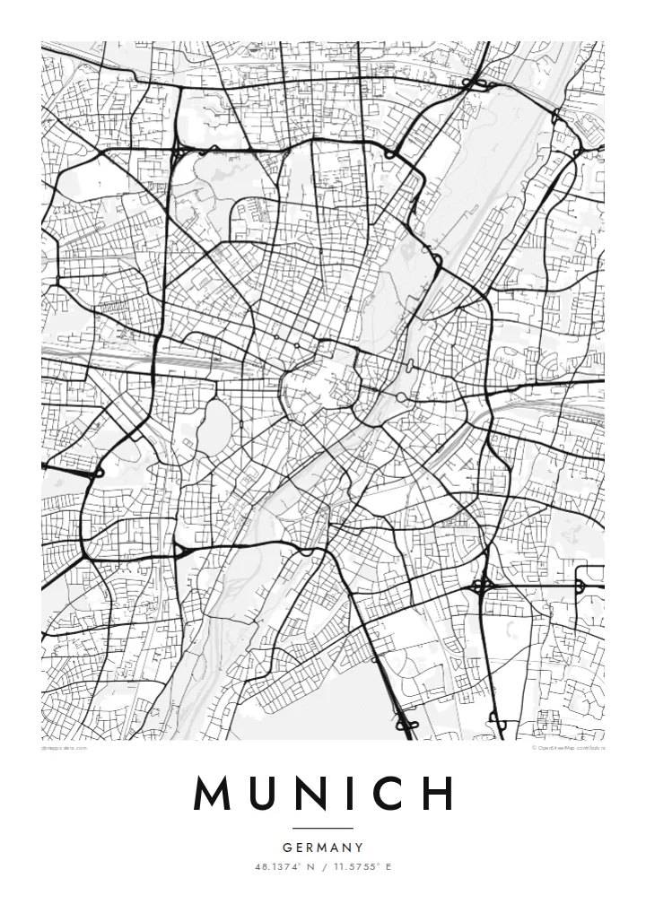
The ring road tracing the former city walls around the old town. It gives the centre a clear, rounded outline that is easy to recognise.
Poster minimalist tal-mappa · il-Ġermanja
48.1374° N / 11.5755° E
A compact old town circled by a ring road, with the Isar River and the English Garden to the east.


Belt waħda, ħames atmosferi
Agħfas fuq stil biex tarah fuq il-ħajt. Kull stil jiswa l-istess — stampat, inkurnat jew bħala fajls HD.
 Pixels reali · fajl tal-istampar 24 × 36″
Preċiż għall-istampar
Dan huwa qtugħ ta' 100% mill-fajl tal-istampar reali. Kull poster — stampat, inkurnat jew iddawnlowdjat — jiġi ġġenerat fuq is-servers tagħna b'300 DPI, sa 7,200 × 10,800 pixel, biex saħansitra l-iżgħar toroq jibqgħu ċari fuq stampa ta' 24 × 36″.
Fuq il-ħajt


Il-mappa
Munich's historic centre is almost round, enclosed by the Altstadtring, a road that follows the line of the old city walls. Inside, streets converge on Marienplatz and its town hall in a dense, irregular pattern. Outside the ring, broad avenues built under the Bavarian kings run in straight lines, such as Ludwigstraße heading north toward the university district.
The Isar River runs north–south along the eastern side of the centre, bordered by green banks. Beside it lies the Englischer Garten, one of the largest urban parks in Europe. Farther out, the Mittlerer Ring circles the inner districts, and landmarks such as the Olympiapark and the long canal of Nymphenburg Palace add distinctive shapes to the northwest.
A Munich map poster brings these layers into balance: the tight old town, the planned royal boulevards, the long corridor of the river and the wide ring road. Each autumn the Theresienwiese fills with Oktoberfest tents, but on the map it simply reads as a calm open space southwest of the centre.
The ring road tracing the former city walls around the old town. It gives the centre a clear, rounded outline that is easy to recognise.
Flowing along the eastern edge of the centre, the river is lined by parkland and bridges, forming a soft band through the city.
A long park stretching north from the centre beside the Isar. Its winding paths and lake create a large open area on the poster.
Agħmlu tiegħek
Żid data, isem jew sentenza tiegħek, ibdel l-istil, id-daqs jew l-orjentazzjoni.
Il-preview b'xejn hija b'riżoluzzjoni baxxa u bil-watermark. L-istampi u l-fajls HD jiġu ġġenerati b'300 DPI, sa 7,200 × 10,800 px, mingħajr watermark.
Għaliex Munich
Munich is a city people often live in for a few years, for study, work or a first job, and remember fondly long after. A map poster holds on to that period, from the old town to a flat in Schwabing or Haidhausen, in a form that fits any room.
Personalise the title, subtitle and coordinates line, and choose from five styles, including Noir and Blueprint for a more graphic look. HD files in six sizes, from A3 to 24×36″, cost $9, or order a matte print with an optional wooden frame.
Ordna l-poster Munich| Daqs tal-istampa | Riżoluzzjoni | Fajls |
|---|---|---|
| 30 × 40 cm (11.8 × 15.7″) | 3,543 × 4,724 px | PNG · PDF |
| 29.7 × 42 cm (A3, 11.7 × 16.5″) | 3,508 × 4,961 px | PNG · PDF |
| 42 × 59.4 cm (A2, 16.5 × 23.4″) | 4,961 × 7,016 px | PNG · PDF |
| 45.7 × 61 cm (18 × 24″) | 5,400 × 7,200 px | PNG · PDF |
| 50 × 70 cm (19.7 × 27.6″) | 5,906 × 8,268 px | PNG · PDF |
| 61 × 91.4 cm (24 × 36″) | 7,200 × 10,800 px | PNG · PDF |
Għal paragun, il-preview b'xejn huwa wiesa' 900 px, għandu watermark u huwa maħsub għall-iskrins. Il-fajls HD għandhom sa 8× ir-riżoluzzjoni f'kull direzzjoni u jiġu stampati b'mod nadif fid-daqs sħiħ tal-poster.
Agħżel stil fin-naħa ta' fuq tal-paġna, imbagħad agħżel Poster Stampat — daqs u, jekk trid, kurniċa — jew Fajls Diġitali HD. Il-ħlas isir f'pass wieħed, u l-paġna tal-ordni tiegħek tiġi aġġornata malli l-ħlas jgħaddi.
Jiġi stampat fuq karta matte premium ta' 200 gsm f'wieħed minn sitt daqsijiet, minn 30 × 40 cm sa 24 × 36″. Il-posters stampati jibdew minn {printFrom}, bil-kunsinna inkluża.
Iva. Agħżel kurniċa tal-injam solidu f'iswed, abjad, ballut naturali jew injam skur. Tiġi bi ħġieġ li ma jinkisirx u lesta biex tittella'. Il-posters inkurnati jibdew minn {framedFrom}, bil-kunsinna inkluża.
Il-kunsinna hija b'xejn madwar id-dinja. Kull poster jiġi stampat mill-eqreb sieħeb tal-istampar tagħna f'aktar minn 30 pajjiż u ġeneralment jasal fi 3–7 ijiem tax-xogħol. Tista' ssegwi l-istatus u t-tracking taħt L-Ordnijiet Tiegħi.
Ibgħatilna ritratt fi żmien 14-il jum mill-kunsinna u aħna nistampawh mill-ġdid b'xejn jew nirrimborżawk.
Iva. Fl-editur ta' din il-paġna, biddel it-titlu, is-sottotitlu u l-linja tal-koordinati għal kwalunkwe ħaġa trid, u agħżel stil u daqs. L-ordnijiet stampati, inkurnati u diġitali kollha jużaw eżattament id-disinn tiegħek.
Għal $9 tikseb fajls PNG b'300 DPI u PDF lesti għall-istampar fis-sitt daqsijiet kollha, mingħajr watermark, biex tistampa kullimkien. Għadek mhux ċert? L-ewwel iddawnlowdja preview b'xejn bil-watermark.
Fil-qrib
