Taedong River
The wide river divides the city into two halves. Several bridges cross it, and embankments give both shores a clean, continuous edge.
Poster minimalist tal-mappa · il-Korea ta’ Fuq
39.0339° N / 125.7543° E
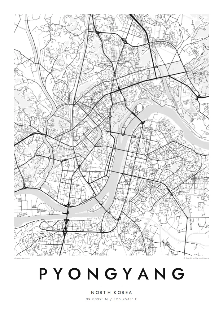
A capital divided by the broad Taedong River, with wide boulevards, riverside monuments and long islands in the stream.


Belt waħda, ħames atmosferi
Agħfas fuq stil biex tarah fuq il-ħajt. Kull stil jiswa l-istess — stampat, inkurnat jew bħala fajls HD.
 Pixels reali · fajl tal-istampar 24 × 36″
Preċiż għall-istampar
Dan huwa qtugħ ta' 100% mill-fajl tal-istampar reali. Kull poster — stampat, inkurnat jew iddawnlowdjat — jiġi ġġenerat fuq is-servers tagħna b'300 DPI, sa 7,200 × 10,800 pixel, biex saħansitra l-iżgħar toroq jibqgħu ċari fuq stampa ta' 24 × 36″.
Fuq il-ħajt


Il-mappa
Pyongyang is built on both banks of the Taedong River, which curves through the city in a wide band and is the dominant feature of the map. The city was almost entirely destroyed during the Korean War and rebuilt from the 1950s onward. Most of what appears from above is a planned layout of broad avenues, large blocks and open squares.
The formal centre faces the river. Kim Il Sung Square opens onto the west bank. Directly opposite, on the east bank, the Juche Tower rises from a riverside plaza, and the two form a deliberate axis across the water. North of the centre, Moranbong Hill is a wooded rise above the river, and the pyramid-shaped Ryugyong Hotel dominates the skyline to the north-west.
The river holds several islands, including Rungra, home to the large May Day Stadium, and Yanggak, with its tall hotel. The Pothong River, a smaller tributary, winds through the western districts. A Pyongyang map poster presents the city simply as geography: river, bridges, islands and the planned grid laid over them, readable without knowing a single street name.
The wide river divides the city into two halves. Several bridges cross it, and embankments give both shores a clean, continuous edge.
A long island in the river upstream of the centre, taken up largely by the May Day Stadium and parkland. Its elongated shape is clearly visible on the map.
Kim Il Sung Square on the west bank and the Juche Tower on the east bank line up across the river. Together they form one of the most deliberate compositions in the city plan.
Agħmlu tiegħek
Żid data, isem jew sentenza tiegħek, ibdel l-istil, id-daqs jew l-orjentazzjoni.
Il-preview b'xejn hija b'riżoluzzjoni baxxa u bil-watermark. L-istampi u l-fajls HD jiġu ġġenerati b'300 DPI, sa 7,200 × 10,800 px, mingħajr watermark.
Għaliex Pyongyang
Few people have walked Pyongyang's streets, which makes its map an unusual object. It works as a study in postwar planning, a reference for readers of Korean history, or a keepsake for those who have visited. The river and islands give it a strong, clean composition.
The title, subtitle and coordinates line can be edited freely. Choose one of five styles, including the high-contrast Noir and the technical Blueprint. The $9 download covers six print sizes as PNG and PDF, and printed posters are also available.
Ordna l-poster Pyongyang| Daqs tal-istampa | Riżoluzzjoni | Fajls |
|---|---|---|
| 30 × 40 cm (11.8 × 15.7″) | 3,543 × 4,724 px | PNG · PDF |
| 29.7 × 42 cm (A3, 11.7 × 16.5″) | 3,508 × 4,961 px | PNG · PDF |
| 42 × 59.4 cm (A2, 16.5 × 23.4″) | 4,961 × 7,016 px | PNG · PDF |
| 45.7 × 61 cm (18 × 24″) | 5,400 × 7,200 px | PNG · PDF |
| 50 × 70 cm (19.7 × 27.6″) | 5,906 × 8,268 px | PNG · PDF |
| 61 × 91.4 cm (24 × 36″) | 7,200 × 10,800 px | PNG · PDF |
Għal paragun, il-preview b'xejn huwa wiesa' 900 px, għandu watermark u huwa maħsub għall-iskrins. Il-fajls HD għandhom sa 8× ir-riżoluzzjoni f'kull direzzjoni u jiġu stampati b'mod nadif fid-daqs sħiħ tal-poster.
Agħżel stil fin-naħa ta' fuq tal-paġna, imbagħad agħżel Poster Stampat — daqs u, jekk trid, kurniċa — jew Fajls Diġitali HD. Il-ħlas isir f'pass wieħed, u l-paġna tal-ordni tiegħek tiġi aġġornata malli l-ħlas jgħaddi.
Jiġi stampat fuq karta matte premium ta' 200 gsm f'wieħed minn sitt daqsijiet, minn 30 × 40 cm sa 24 × 36″. Il-posters stampati jibdew minn $39, bil-kunsinna inkluża.
Iva. Agħżel kurniċa tal-injam solidu f'iswed, abjad, ballut naturali jew injam skur. Tiġi bi ħġieġ li ma jinkisirx u lesta biex tittella'. Il-posters inkurnati jibdew minn $99, bil-kunsinna inkluża.
L-ispedizzjoni hija b'xejn mad-dinja kollha. Kull poster jiġi stampat mill-eqreb wieħed mis-sieħba tal-istampar tagħna f'aktar minn 30 pajjiż u normalment jaslilek fi 3–7 ijiem tax-xogħol. Tista' tsegwi l-istatus u t-traċċar taħt L-Ordnijiet Tiegħi. Xi pajjiżi jieħdu 2–5 ġimgħat, u fejn għadna ma nispedixxux, is-sit jgħidlek qabel ma tħallas.
Ibgħatilna ritratt fi żmien 14-il jum mill-kunsinna u aħna nistampawh mill-ġdid b'xejn jew nirrimborżawk.
Iva. Fl-editur ta' din il-paġna, biddel it-titlu, is-sottotitlu u l-linja tal-koordinati għal kwalunkwe ħaġa trid, u agħżel stil u daqs. L-ordnijiet stampati, inkurnati u diġitali kollha jużaw eżattament id-disinn tiegħek.
Għal $9 tikseb fajls PNG b'300 DPI u PDF lesti għall-istampar fis-sitt daqsijiet kollha, mingħajr watermark, biex tistampa kullimkien. Għadek mhux ċert? L-ewwel iddawnlowdja preview b'xejn bil-watermark.
