The Gier corridor
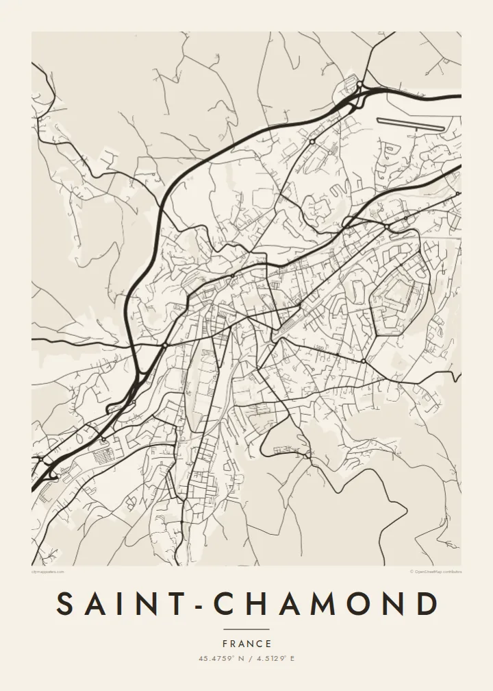
The river, the railway and the main roads run through the valley together, forming a strong diagonal line that sets the direction of the whole map.
Poster minimalist tal-mappa · Franza
45.4759° N / 4.5129° E
A long industrial town stretched along the narrow Gier valley, with the road, the rail line and the river running side by side




Belt waħda, ħames atmosferi
Agħfas fuq stil biex tarah fuq il-ħajt. Kull stil jiswa l-istess — stampat, inkurnat jew bħala fajls HD.
 Pixels reali · fajl tal-istampar 24 × 36″
Preċiż għall-istampar
Dan huwa qtugħ ta' 100% mill-fajl tal-istampar reali. Kull poster — stampat, inkurnat jew iddawnlowdjat — jiġi ġġenerat fuq is-servers tagħna b'300 DPI, sa 7,200 × 10,800 pixel, biex saħansitra l-iżgħar toroq jibqgħu ċari fuq stampa ta' 24 × 36″.
Fuq il-ħajt


Il-mappa
Saint-Chamond sits in the Gier valley in the Loire department, between Saint-Étienne and the Rhône. On a map the town is long and narrow, shaped by the valley floor. The main roads, the railway and the river all run roughly parallel from southwest to northeast, and housing climbs the slopes on either side until the terrain gets too steep to build on.
For well over a century the town was an industrial centre. Ribbon and braid workshops came first, followed by heavy steelworks. The forges here gave their name to the Saint-Chamond tank, one of the first French armoured vehicles of the First World War. The large former factory grounds near the centre have since been redeveloped, and they still show up in the street plan as a broad, open block among the older, denser streets.
A Saint-Chamond map poster shows that valley layout clearly: a dense central band, secondary streets branching into side valleys, and the outline of the old town where the lanes are closer together. To the south the streets thin out towards the wooded heights of the Pilat regional park, and that fading of the grid gives the print a natural edge.
The river, the railway and the main roads run through the valley together, forming a strong diagonal line that sets the direction of the whole map.
The old industrial site near the centre appears as a wide block with a looser pattern of streets, a trace of the forges that once employed much of the town.
On both sides of the valley the grid breaks into winding roads and short cul-de-sacs as it reaches steeper ground, giving the edges of the map a softer, uneven texture.
Agħmlu tiegħek
Żid data, isem jew sentenza tiegħek, ibdel l-istil, id-daqs jew l-orjentazzjoni.
Il-preview b'xejn hija b'riżoluzzjoni baxxa u bil-watermark. L-istampi u l-fajls HD jiġu ġġenerati b'300 DPI, sa 7,200 × 10,800 px, mingħajr watermark.
Għaliex Saint-Chamond
People who grew up in the Gier valley, or worked in its factories, often want the place they know as a real shape on the wall. The long, directional outline of Saint-Chamond makes for an unusual composition, quite different from a round city centre.
You can change the title, subtitle and coordinates line to mark a family name, a street or a year, and choose one of five styles: Classic black & white, Noir, Paper, Blueprint or Sand. It comes as a $9 digital download or as a printed poster on matte paper, with an optional wooden frame.
Ordna l-poster Saint-Chamond| Daqs tal-istampa | Riżoluzzjoni | Fajls |
|---|---|---|
| 30 × 40 cm (11.8 × 15.7″) | 3,543 × 4,724 px | PNG · PDF |
| 29.7 × 42 cm (A3, 11.7 × 16.5″) | 3,508 × 4,961 px | PNG · PDF |
| 42 × 59.4 cm (A2, 16.5 × 23.4″) | 4,961 × 7,016 px | PNG · PDF |
| 45.7 × 61 cm (18 × 24″) | 5,400 × 7,200 px | PNG · PDF |
| 50 × 70 cm (19.7 × 27.6″) | 5,906 × 8,268 px | PNG · PDF |
| 61 × 91.4 cm (24 × 36″) | 7,200 × 10,800 px | PNG · PDF |
Għal paragun, il-preview b'xejn huwa wiesa' 900 px, għandu watermark u huwa maħsub għall-iskrins. Il-fajls HD għandhom sa 8× ir-riżoluzzjoni f'kull direzzjoni u jiġu stampati b'mod nadif fid-daqs sħiħ tal-poster.
Agħżel stil fin-naħa ta' fuq tal-paġna, imbagħad agħżel Poster Stampat — daqs u, jekk trid, kurniċa — jew Fajls Diġitali HD. Il-ħlas isir f'pass wieħed, u l-paġna tal-ordni tiegħek tiġi aġġornata malli l-ħlas jgħaddi.
Jiġi stampat fuq karta matte premium ta' 200 gsm f'wieħed minn sitt daqsijiet, minn 30 × 40 cm sa 24 × 36″. Il-posters stampati jibdew minn $39, bil-kunsinna inkluża.
Iva. Agħżel kurniċa tal-injam solidu f'iswed, abjad, ballut naturali jew injam skur. Tiġi bi ħġieġ li ma jinkisirx u lesta biex tittella'. Il-posters inkurnati jibdew minn $99, bil-kunsinna inkluża.
L-ispedizzjoni hija b'xejn mad-dinja kollha. Kull poster jiġi stampat mill-eqreb wieħed mis-sieħba tal-istampar tagħna f'aktar minn 30 pajjiż u normalment jaslilek fi 3–7 ijiem tax-xogħol. Tista' tsegwi l-istatus u t-traċċar taħt L-Ordnijiet Tiegħi. Xi pajjiżi jieħdu 2–5 ġimgħat, u fejn għadna ma nispedixxux, is-sit jgħidlek qabel ma tħallas.
Ibgħatilna ritratt fi żmien 14-il jum mill-kunsinna u aħna nistampawh mill-ġdid b'xejn jew nirrimborżawk.
Iva. Fl-editur ta' din il-paġna, biddel it-titlu, is-sottotitlu u l-linja tal-koordinati għal kwalunkwe ħaġa trid, u agħżel stil u daqs. L-ordnijiet stampati, inkurnati u diġitali kollha jużaw eżattament id-disinn tiegħek.
Għal $9 tikseb fajls PNG b'300 DPI u PDF lesti għall-istampar fis-sitt daqsijiet kollha, mingħajr watermark, biex tistampa kullimkien. Għadek mhux ċert? L-ewwel iddawnlowdja preview b'xejn bil-watermark.
Fil-qrib
