Lake Kivu shoreline
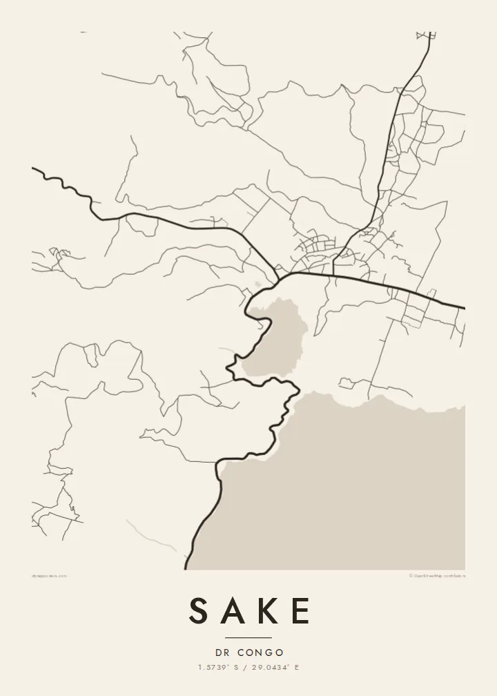
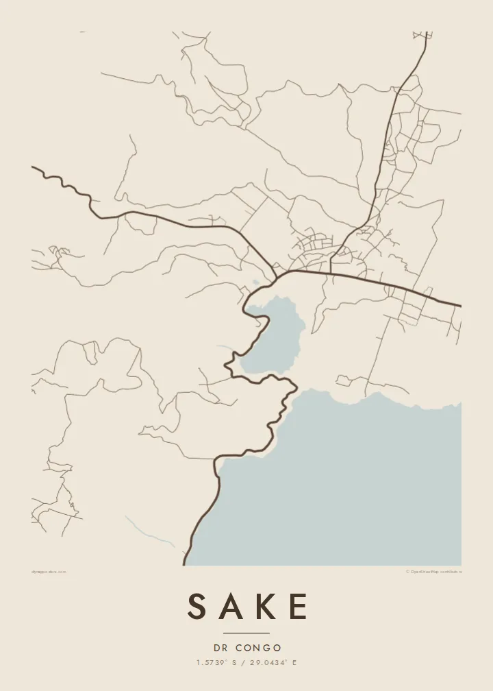
The northern edge of Lake Kivu forms a clean boundary along one side of the town, leaving a broad field of open water that balances the busier land area.
Poster minimalist tal-mappa · ir-Repubblika Demokratika tal-Kongo
1.5739° S / 29.0434° E
A lakeside town at the northwestern tip of Lake Kivu, framed by steep green hills and volcanic ground.



Belt waħda, ħames atmosferi
Agħfas fuq stil biex tarah fuq il-ħajt. Kull stil jiswa l-istess — stampat, inkurnat jew bħala fajls HD.
 Pixels reali · fajl tal-istampar 24 × 36″
Preċiż għall-istampar
Dan huwa qtugħ ta' 100% mill-fajl tal-istampar reali. Kull poster — stampat, inkurnat jew iddawnlowdjat — jiġi ġġenerat fuq is-servers tagħna b'300 DPI, sa 7,200 × 10,800 pixel, biex saħansitra l-iżgħar toroq jibqgħu ċari fuq stampa ta' 24 × 36″.
Fuq il-ħajt


Il-mappa
Sake lies where the northern shore of Lake Kivu turns toward the hills of Masisi, a short distance west of Goma. On a map the town is squeezed between water and high ground, with its streets gathered along the main road and the lakeshore. The shoreline gives the plan a strong natural edge, while the slopes behind it close in quickly.
The town has long been a crossroads in North Kivu, where the road from Goma meets routes heading west into the highlands and south along the lake. That position has made it important for trade and travel in the region. The wider landscape is shaped by the volcanic Virunga country to the north, with fertile soils and sharply folded terrain.
A Sake map poster brings together two very different surfaces: the calm, empty expanse of Lake Kivu and the dense, irregular pattern of streets and paths on land. In black and white the coastline becomes the defining line of the composition, and the hills are suggested by the way roads twist to find a way through them.
The northern edge of Lake Kivu forms a clean boundary along one side of the town, leaving a broad field of open water that balances the busier land area.
Sake sits where the road west from Goma meets routes into the Masisi highlands and along the lakeshore, so several lines converge on the town centre.
Steep, green slopes rise close to the lake, and the roads and paths that climb them bend sharply, giving the edges of the map a winding texture.
Agħmlu tiegħek
Żid data, isem jew sentenza tiegħek, ibdel l-istil, id-daqs jew l-orjentazzjoni.
Il-preview b'xejn hija b'riżoluzzjoni baxxa u bil-watermark. L-istampi u l-fajls HD jiġu ġġenerati b'300 DPI, sa 7,200 × 10,800 px, mingħajr watermark.
Għaliex Sake
A map of Sake is a way to keep hold of a place defined by its lake and hills, whether for people who grew up there, family members living abroad, or those who have worked in North Kivu and remember its landscape.
Personalise the title, subtitle and coordinates line, then choose one of five styles: Classic black & white, Noir, Paper, Blueprint or Sand. A free 900 px preview lets you check the frame before buying HD files for $9 or ordering a printed poster.
Ordna l-poster Sake| Daqs tal-istampa | Riżoluzzjoni | Fajls |
|---|---|---|
| 30 × 40 cm (11.8 × 15.7″) | 3,543 × 4,724 px | PNG · PDF |
| 29.7 × 42 cm (A3, 11.7 × 16.5″) | 3,508 × 4,961 px | PNG · PDF |
| 42 × 59.4 cm (A2, 16.5 × 23.4″) | 4,961 × 7,016 px | PNG · PDF |
| 45.7 × 61 cm (18 × 24″) | 5,400 × 7,200 px | PNG · PDF |
| 50 × 70 cm (19.7 × 27.6″) | 5,906 × 8,268 px | PNG · PDF |
| 61 × 91.4 cm (24 × 36″) | 7,200 × 10,800 px | PNG · PDF |
Għal paragun, il-preview b'xejn huwa wiesa' 900 px, għandu watermark u huwa maħsub għall-iskrins. Il-fajls HD għandhom sa 8× ir-riżoluzzjoni f'kull direzzjoni u jiġu stampati b'mod nadif fid-daqs sħiħ tal-poster.
Agħżel stil fin-naħa ta' fuq tal-paġna, imbagħad agħżel Poster Stampat — daqs u, jekk trid, kurniċa — jew Fajls Diġitali HD. Il-ħlas isir f'pass wieħed, u l-paġna tal-ordni tiegħek tiġi aġġornata malli l-ħlas jgħaddi.
Jiġi stampat fuq karta matte premium ta' 200 gsm f'wieħed minn sitt daqsijiet, minn 30 × 40 cm sa 24 × 36″. Il-posters stampati jibdew minn {printFrom}, bil-kunsinna inkluża.
Iva. Agħżel kurniċa tal-injam solidu f'iswed, abjad, ballut naturali jew injam skur. Tiġi bi ħġieġ li ma jinkisirx u lesta biex tittella'. Il-posters inkurnati jibdew minn {framedFrom}, bil-kunsinna inkluża.
Il-kunsinna hija b'xejn madwar id-dinja. Kull poster jiġi stampat mill-eqreb sieħeb tal-istampar tagħna f'aktar minn 30 pajjiż u ġeneralment jasal fi 3–7 ijiem tax-xogħol. Tista' ssegwi l-istatus u t-tracking taħt L-Ordnijiet Tiegħi.
Ibgħatilna ritratt fi żmien 14-il jum mill-kunsinna u aħna nistampawh mill-ġdid b'xejn jew nirrimborżawk.
Iva. Fl-editur ta' din il-paġna, biddel it-titlu, is-sottotitlu u l-linja tal-koordinati għal kwalunkwe ħaġa trid, u agħżel stil u daqs. L-ordnijiet stampati, inkurnati u diġitali kollha jużaw eżattament id-disinn tiegħek.
Għal $9 tikseb fajls PNG b'300 DPI u PDF lesti għall-istampar fis-sitt daqsijiet kollha, mingħajr watermark, biex tistampa kullimkien. Għadek mhux ċert? L-ewwel iddawnlowdja preview b'xejn bil-watermark.
