The Ghaghara margin
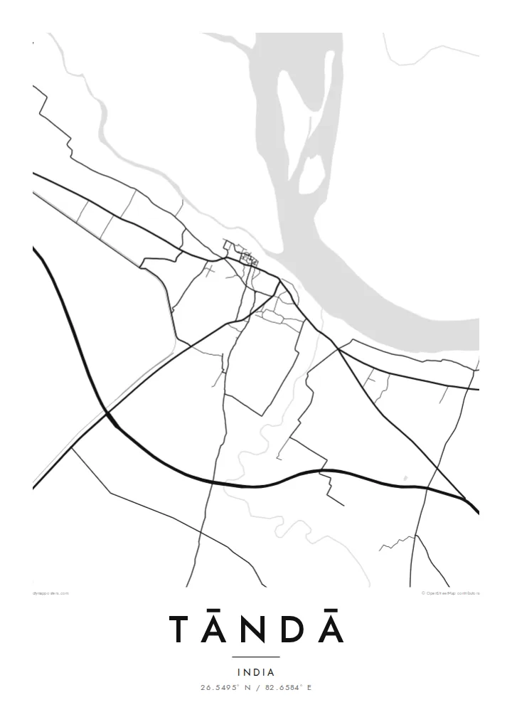
The river's broad floodplain forms the northern edge of the map. It is a wide, mostly empty band that makes the dense town beside it look even tighter.
Poster minimalist tal-mappa · l-Indja
26.5495° N / 82.6584° E
A weaving town on the south bank of the Ghaghara, with a compact core and wide river flats to the north.


Belt waħda, ħames atmosferi
Agħfas fuq stil biex tarah fuq il-ħajt. Kull stil jiswa l-istess — stampat, inkurnat jew bħala fajls HD.
 Pixels reali · fajl tal-istampar 24 × 36″
Preċiż għall-istampar
Dan huwa qtugħ ta' 100% mill-fajl tal-istampar reali. Kull poster — stampat, inkurnat jew iddawnlowdjat — jiġi ġġenerat fuq is-servers tagħna b'300 DPI, sa 7,200 × 10,800 pixel, biex saħansitra l-iżgħar toroq jibqgħu ċari fuq stampa ta' 24 × 36″.
Fuq il-ħajt


Il-mappa
Tāndā lies in Ambedkar Nagar district in eastern Uttar Pradesh, on the southern bank of the Ghaghara, the broad river also known downstream as the Saryu. The town's layout is shaped by that position. The dense older quarters sit back from the water, and the ground towards the river opens into wide, low-lying flats that shift with each monsoon.
Tāndā has a long tradition of handloom weaving and is especially known for its cotton textiles. The work has historically taken place in small workshops woven into residential neighbourhoods, so the town centre is fine-grained: narrow streets, short blocks and very little open space. On a Tāndā map poster, that dense core stands out sharply against the empty river margin.
The area is also home to a large thermal power station, whose site and cooling infrastructure add a set of clean geometric shapes on the outskirts. Past that, rural roads spread out across the flat Gangetic plain towards surrounding villages. The overall picture is simple and legible: a river to the north, a compact town, and farmland stretching away in every other direction.
The river's broad floodplain forms the northern edge of the map. It is a wide, mostly empty band that makes the dense town beside it look even tighter.
The old neighbourhoods where handloom work took place form a close mesh of narrow lanes. At poster scale they read as a dark, intricate patch of detail.
Beyond the town, straight rural roads fan out across flat farmland towards neighbouring villages. They give the composition a calm, open frame.
Agħmlu tiegħek
Żid data, isem jew sentenza tiegħek, ibdel l-istil, id-daqs jew l-orjentazzjoni.
Il-preview b'xejn hija b'riżoluzzjoni baxxa u bil-watermark. L-istampi u l-fajls HD jiġu ġġenerati b'300 DPI, sa 7,200 × 10,800 px, mingħajr watermark.
Għaliex Tāndā
A map of Tāndā speaks to anyone connected to its looms, its river or its families. It is a modest place with a clear shape, and the contrast between the crowded core and the open riverbank works well on the wall.
The title, subtitle and coordinates line can all be personalised, whether with a surname, a wedding date or simply the town's name. Choose from five styles, including the soft Paper tone or the technical-looking Blueprint.
Ordna l-poster Tāndā| Daqs tal-istampa | Riżoluzzjoni | Fajls |
|---|---|---|
| 30 × 40 cm (11.8 × 15.7″) | 3,543 × 4,724 px | PNG · PDF |
| 29.7 × 42 cm (A3, 11.7 × 16.5″) | 3,508 × 4,961 px | PNG · PDF |
| 42 × 59.4 cm (A2, 16.5 × 23.4″) | 4,961 × 7,016 px | PNG · PDF |
| 45.7 × 61 cm (18 × 24″) | 5,400 × 7,200 px | PNG · PDF |
| 50 × 70 cm (19.7 × 27.6″) | 5,906 × 8,268 px | PNG · PDF |
| 61 × 91.4 cm (24 × 36″) | 7,200 × 10,800 px | PNG · PDF |
Għal paragun, il-preview b'xejn huwa wiesa' 900 px, għandu watermark u huwa maħsub għall-iskrins. Il-fajls HD għandhom sa 8× ir-riżoluzzjoni f'kull direzzjoni u jiġu stampati b'mod nadif fid-daqs sħiħ tal-poster.
Agħżel stil fin-naħa ta' fuq tal-paġna, imbagħad agħżel Poster Stampat — daqs u, jekk trid, kurniċa — jew Fajls Diġitali HD. Il-ħlas isir f'pass wieħed, u l-paġna tal-ordni tiegħek tiġi aġġornata malli l-ħlas jgħaddi.
Jiġi stampat fuq karta matte premium ta' 200 gsm f'wieħed minn sitt daqsijiet, minn 30 × 40 cm sa 24 × 36″. Il-posters stampati jibdew minn {printFrom}, bil-kunsinna inkluża.
Iva. Agħżel kurniċa tal-injam solidu f'iswed, abjad, ballut naturali jew injam skur. Tiġi bi ħġieġ li ma jinkisirx u lesta biex tittella'. Il-posters inkurnati jibdew minn {framedFrom}, bil-kunsinna inkluża.
Il-kunsinna hija b'xejn madwar id-dinja. Kull poster jiġi stampat mill-eqreb sieħeb tal-istampar tagħna f'aktar minn 30 pajjiż u ġeneralment jasal fi 3–7 ijiem tax-xogħol. Tista' ssegwi l-istatus u t-tracking taħt L-Ordnijiet Tiegħi.
Ibgħatilna ritratt fi żmien 14-il jum mill-kunsinna u aħna nistampawh mill-ġdid b'xejn jew nirrimborżawk.
Iva. Fl-editur ta' din il-paġna, biddel it-titlu, is-sottotitlu u l-linja tal-koordinati għal kwalunkwe ħaġa trid, u agħżel stil u daqs. L-ordnijiet stampati, inkurnati u diġitali kollha jużaw eżattament id-disinn tiegħek.
Għal $9 tikseb fajls PNG b'300 DPI u PDF lesti għall-istampar fis-sitt daqsijiet kollha, mingħajr watermark, biex tistampa kullimkien. Għadek mhux ċert? L-ewwel iddawnlowdja preview b'xejn bil-watermark.
