Piazza Unità d'Italia
The main square is open on one side to the sea, a large rectangle on the waterfront that is instantly recognisable on the map.
Poster minimalist tal-mappa · l-Italja
45.6495° N / 13.7768° E
A harbour city curved around its gulf, with a Habsburg grid by the sea and the Karst plateau rising steeply behind.




Belt waħda, ħames atmosferi
Agħfas fuq stil biex tarah fuq il-ħajt. Kull stil jiswa l-istess — stampat, inkurnat jew bħala fajls HD.
 Pixels reali · fajl tal-istampar 24 × 36″
Preċiż għall-istampar
Dan huwa qtugħ ta' 100% mill-fajl tal-istampar reali. Kull poster — stampat, inkurnat jew iddawnlowdjat — jiġi ġġenerat fuq is-servers tagħna b'300 DPI, sa 7,200 × 10,800 pixel, biex saħansitra l-iżgħar toroq jibqgħu ċari fuq stampa ta' 24 × 36″.
Fuq il-ħajt


Il-mappa
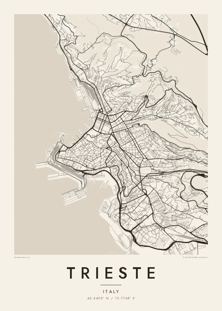
Trieste occupies a narrow strip of land between the Adriatic and the limestone Karst plateau, close to the Slovenian border. The map shows a city pressed against the water: a long seafront, piers reaching into the gulf and streets climbing in switchbacks up the slopes behind. At the top, the edge of the Karst forms a sharp line beyond which the land flattens into villages and woodland.
At the centre, Piazza Unità d'Italia opens directly onto the sea, one of the largest seafront squares in Europe. Behind it lies the Borgo Teresiano, an eighteenth-century grid laid out under Maria Theresa and cut through by the short Canal Grande. For centuries Trieste was the main port of the Habsburg Empire, and James Joyce lived here for more than a decade.
A Trieste map poster brings together the seafront, the old port, the Canal Grande and the hill of San Giusto in one clean composition. It suits those who know the city from its coffee houses and waterfront walks, and anyone drawn to border cities where Italian, Slovene and Central European influences meet.
The main square is open on one side to the sea, a large rectangle on the waterfront that is instantly recognisable on the map.
North of the square, a regular grid of eighteenth-century streets surrounds the Canal Grande, a short, straight channel that runs inland from the harbour.
Above the city the limestone plateau rises steeply, so the map shows tight, winding roads climbing the slope before reaching the open Karst on top.
Agħmlu tiegħek
Żid data, isem jew sentenza tiegħek, ibdel l-istil, id-daqs jew l-orjentazzjoni.
Il-preview b'xejn hija b'riżoluzzjoni baxxa u bil-watermark. L-istampi u l-fajls HD jiġu ġġenerati b'300 DPI, sa 7,200 × 10,800 px, mingħajr watermark.
Għaliex Trieste
Trieste attracts writers, sailors, scientists and people who simply fell for its seafront and wind. A map of its harbour and hills is a restrained way to remember time spent there, or to celebrate a family tie to the city.
The title, subtitle and coordinates line can be personalised, and the poster comes in five styles: Classic black & white, Noir, Paper, Blueprint and Sand. Printed posters on matte paper ship from partners in over 30 countries.
Ordna l-poster Trieste| Daqs tal-istampa | Riżoluzzjoni | Fajls |
|---|---|---|
| 30 × 40 cm (11.8 × 15.7″) | 3,543 × 4,724 px | PNG · PDF |
| 29.7 × 42 cm (A3, 11.7 × 16.5″) | 3,508 × 4,961 px | PNG · PDF |
| 42 × 59.4 cm (A2, 16.5 × 23.4″) | 4,961 × 7,016 px | PNG · PDF |
| 45.7 × 61 cm (18 × 24″) | 5,400 × 7,200 px | PNG · PDF |
| 50 × 70 cm (19.7 × 27.6″) | 5,906 × 8,268 px | PNG · PDF |
| 61 × 91.4 cm (24 × 36″) | 7,200 × 10,800 px | PNG · PDF |
Għal paragun, il-preview b'xejn huwa wiesa' 900 px, għandu watermark u huwa maħsub għall-iskrins. Il-fajls HD għandhom sa 8× ir-riżoluzzjoni f'kull direzzjoni u jiġu stampati b'mod nadif fid-daqs sħiħ tal-poster.
Agħżel stil fin-naħa ta' fuq tal-paġna, imbagħad agħżel Poster Stampat — daqs u, jekk trid, kurniċa — jew Fajls Diġitali HD. Il-ħlas isir f'pass wieħed, u l-paġna tal-ordni tiegħek tiġi aġġornata malli l-ħlas jgħaddi.
Jiġi stampat fuq karta matte premium ta' 200 gsm f'wieħed minn sitt daqsijiet, minn 30 × 40 cm sa 24 × 36″. Il-posters stampati jibdew minn {printFrom}, bil-kunsinna inkluża.
Iva. Agħżel kurniċa tal-injam solidu f'iswed, abjad, ballut naturali jew injam skur. Tiġi bi ħġieġ li ma jinkisirx u lesta biex tittella'. Il-posters inkurnati jibdew minn {framedFrom}, bil-kunsinna inkluża.
Il-kunsinna hija b'xejn madwar id-dinja. Kull poster jiġi stampat mill-eqreb sieħeb tal-istampar tagħna f'aktar minn 30 pajjiż u ġeneralment jasal fi 3–7 ijiem tax-xogħol. Tista' ssegwi l-istatus u t-tracking taħt L-Ordnijiet Tiegħi.
Ibgħatilna ritratt fi żmien 14-il jum mill-kunsinna u aħna nistampawh mill-ġdid b'xejn jew nirrimborżawk.
Iva. Fl-editur ta' din il-paġna, biddel it-titlu, is-sottotitlu u l-linja tal-koordinati għal kwalunkwe ħaġa trid, u agħżel stil u daqs. L-ordnijiet stampati, inkurnati u diġitali kollha jużaw eżattament id-disinn tiegħek.
Għal $9 tikseb fajls PNG b'300 DPI u PDF lesti għall-istampar fis-sitt daqsijiet kollha, mingħajr watermark, biex tistampa kullimkien. Għadek mhux ċert? L-ewwel iddawnlowdja preview b'xejn bil-watermark.
