The Una River
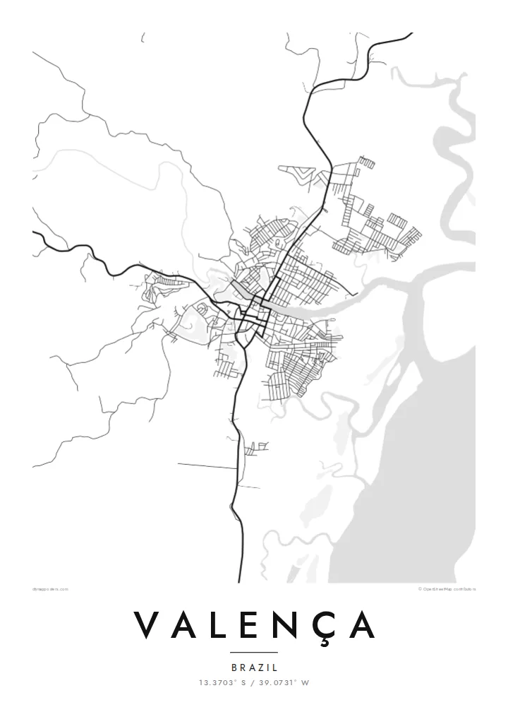
The river runs straight through the town and is its main organising line on the map, with streets and blocks lining both banks and bridges stitching the two halves together.
Poster minimalist tal-mappa · Il-Brażil
13.3703° S / 39.0731° W
A river town on the Una estuary, its streets following both banks before mangrove channels open toward the Atlantic coast of Bahia


Belt waħda, ħames atmosferi
Agħfas fuq stil biex tarah fuq il-ħajt. Kull stil jiswa l-istess — stampat, inkurnat jew bħala fajls HD.
 Pixels reali · fajl tal-istampar 24 × 36″
Preċiż għall-istampar
Dan huwa qtugħ ta' 100% mill-fajl tal-istampar reali. Kull poster — stampat, inkurnat jew iddawnlowdjat — jiġi ġġenerat fuq is-servers tagħna b'300 DPI, sa 7,200 × 10,800 pixel, biex saħansitra l-iżgħar toroq jibqgħu ċari fuq stampa ta' 24 × 36″.
Fuq il-ħajt


Il-mappa
Valença sits on the Una River a short way inland from the Bahian coast, and from above the river decides everything. The town spreads along both banks, joined by bridges, with the older core close to the water and newer neighbourhoods climbing the low hills behind. Downstream, the channel widens into an estuary edged with mangroves, where solid land gives way to a loose pattern of creeks and islands.
This layout has long made Valença a place of arrival and departure. Boats leave its waterfront for the islands of the Tinharé archipelago, including Morro de São Paulo and Boipeba, and the town has a long tradition of building wooden boats by hand. In the nineteenth century it also became home to one of Brazil's early textile mills, which drew on the river for its power.
A Valença map poster turns this river geography into a clear graphic. The Una draws a strong line through the composition, the street grid gathers tightly around it, and the estuary to the east breaks into fine, irregular shapes. In black and white, the contrast between the dense town and the open water reads especially well, giving the print both structure and a sense of the coast just beyond it.
The river runs straight through the town and is its main organising line on the map, with streets and blocks lining both banks and bridges stitching the two halves together.
East of the centre, the river widens and splits into channels among mangroves, so the plain outline of the land dissolves into delicate, branching water shapes toward the sea.
The waterfront is a departure point for boats to the Tinharé archipelago, including Morro de São Paulo and Boipeba, which ties the town's plan closely to the water.
Agħmlu tiegħek
Żid data, isem jew sentenza tiegħek, ibdel l-istil, id-daqs jew l-orjentazzjoni.
Il-preview b'xejn hija b'riżoluzzjoni baxxa u bil-watermark. L-istampi u l-fajls HD jiġu ġġenerati b'300 DPI, sa 7,200 × 10,800 px, mingħajr watermark.
Għaliex Valença
For people who grew up in Valença, or who passed through on the way to the islands, this map holds a particular route: the river, the quay, the streets leading down to the boats. It is a quiet reminder of a place defined by water and travel.
Each poster can be personalised with your own title, subtitle and coordinates line, perhaps a family name or the date of a trip. Choose from five styles, Classic black & white, Noir, Paper, Blueprint or Sand, to suit the room where it will hang.
Ordna l-poster Valença| Daqs tal-istampa | Riżoluzzjoni | Fajls |
|---|---|---|
| 30 × 40 cm (11.8 × 15.7″) | 3,543 × 4,724 px | PNG · PDF |
| 29.7 × 42 cm (A3, 11.7 × 16.5″) | 3,508 × 4,961 px | PNG · PDF |
| 42 × 59.4 cm (A2, 16.5 × 23.4″) | 4,961 × 7,016 px | PNG · PDF |
| 45.7 × 61 cm (18 × 24″) | 5,400 × 7,200 px | PNG · PDF |
| 50 × 70 cm (19.7 × 27.6″) | 5,906 × 8,268 px | PNG · PDF |
| 61 × 91.4 cm (24 × 36″) | 7,200 × 10,800 px | PNG · PDF |
Għal paragun, il-preview b'xejn huwa wiesa' 900 px, għandu watermark u huwa maħsub għall-iskrins. Il-fajls HD għandhom sa 8× ir-riżoluzzjoni f'kull direzzjoni u jiġu stampati b'mod nadif fid-daqs sħiħ tal-poster.
Agħżel stil fin-naħa ta' fuq tal-paġna, imbagħad agħżel Poster Stampat — daqs u, jekk trid, kurniċa — jew Fajls Diġitali HD. Il-ħlas isir f'pass wieħed, u l-paġna tal-ordni tiegħek tiġi aġġornata malli l-ħlas jgħaddi.
Jiġi stampat fuq karta matte premium ta' 200 gsm f'wieħed minn sitt daqsijiet, minn 30 × 40 cm sa 24 × 36″. Il-posters stampati jibdew minn {printFrom}, bil-kunsinna inkluża.
Iva. Agħżel kurniċa tal-injam solidu f'iswed, abjad, ballut naturali jew injam skur. Tiġi bi ħġieġ li ma jinkisirx u lesta biex tittella'. Il-posters inkurnati jibdew minn {framedFrom}, bil-kunsinna inkluża.
Il-kunsinna hija b'xejn madwar id-dinja. Kull poster jiġi stampat mill-eqreb sieħeb tal-istampar tagħna f'aktar minn 30 pajjiż u ġeneralment jasal fi 3–7 ijiem tax-xogħol. Tista' ssegwi l-istatus u t-tracking taħt L-Ordnijiet Tiegħi.
Ibgħatilna ritratt fi żmien 14-il jum mill-kunsinna u aħna nistampawh mill-ġdid b'xejn jew nirrimborżawk.
Iva. Fl-editur ta' din il-paġna, biddel it-titlu, is-sottotitlu u l-linja tal-koordinati għal kwalunkwe ħaġa trid, u agħżel stil u daqs. L-ordnijiet stampati, inkurnati u diġitali kollha jużaw eżattament id-disinn tiegħek.
Għal $9 tikseb fajls PNG b'300 DPI u PDF lesti għall-istampar fis-sitt daqsijiet kollha, mingħajr watermark, biex tistampa kullimkien. Għadek mhux ċert? L-ewwel iddawnlowdja preview b'xejn bil-watermark.
Fil-qrib
