Congtai Park
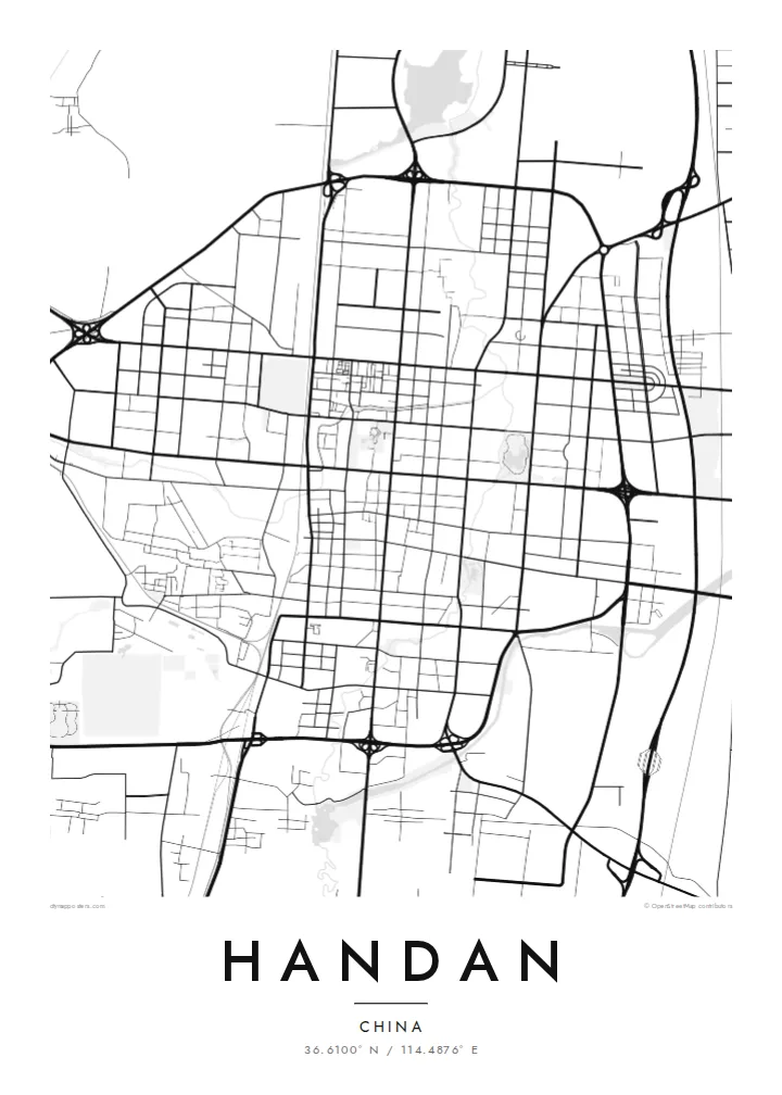
A large park with a lake near the city centre, built around an old terrace linked to the Zhao kings. On the map it forms an open, rounded shape among the rectangular blocks.
Minimalist map poster · China
36.6100° N / 114.4876° E
A broad, regular grid on the North China Plain, crossed by the Fuyang River below the Taihang foothills


One city, five moods
Ekamowa emwit style ouga bwe ouga ekamowa e dedaña ñan bwega. Style otata a kor eangan — eprint, eframe ke HD files.
 Pixel ekwan · 24 × 36″ print file
Print-sharp
Enin 100% crop eo mai print file eo elango. Poster otata — eprint, eframe ke edownload — erender iaan server bwir e 300 DPI, dedaña ñan 7,200 × 10,800 pixels, bwe lane ekekedik ekwan ebwe crisp iaan print 24 × 36″.
Ituro


The map
Handan is one of China's oldest cities. It served as the capital of the State of Zhao during the Warring States period and has kept the same name for close to three thousand years. It is often called the home of Chinese idioms, since a large number of classical four-character sayings, among them the story of learning to walk in Handan, trace their origins to events set here.
The modern city is laid out on the flat North China Plain, with the foothills of the Taihang Mountains rising to the west. On the map it reads as a broad, regular grid of wide avenues and large blocks, crossed by the winding Fuyang River and by the main north–south railway, with industrial districts spread across its outer areas.
Near the centre, Congtai Park surrounds a lake and the raised terrace traditionally associated with King Wuling of Zhao. A Handan map poster sets this green space and the curve of the river against the rigour of the street grid, producing a composition that is ordered yet not mechanical, and that reflects both the ancient capital and the working industrial city.
A large park with a lake near the city centre, built around an old terrace linked to the Zhao kings. On the map it forms an open, rounded shape among the rectangular blocks.
The river winds through Handan in gentle curves, the main natural line crossing an otherwise strictly rectilinear city.
Wide avenues running north–south and east–west divide Handan into large, even blocks, a pattern that gives the poster its calm and measured rhythm.
Make it yours
Add a date, a name or a line of your own, switch style, size or orientation.
Preview ededa low-resolution im watermark. Print im HD files erender iaan 300 DPI, dedaña ñan 7,200 × 10,800 px, ededa watermark.
Why Handan
Handan appeals to people with family roots in southern Hebei, and to anyone drawn to cities where ancient history lies under a modern plan. Its orderly grid and single winding river make a clean, graphic image that works in both traditional and contemporary interiors.
Add your own title, perhaps a favourite idiom or a family name, and a date or place in the subtitle, with an editable coordinates line. Five styles are available: Classic black & white, Noir, Paper, Blueprint and Sand.
Oder poster Handan| Print size | Resolution | Files |
|---|---|---|
| 30 × 40 cm (11.8 × 15.7″) | 3,543 × 4,724 px | PNG · PDF |
| 29.7 × 42 cm (A3, 11.7 × 16.5″) | 3,508 × 4,961 px | PNG · PDF |
| 42 × 59.4 cm (A2, 16.5 × 23.4″) | 4,961 × 7,016 px | PNG · PDF |
| 45.7 × 61 cm (18 × 24″) | 5,400 × 7,200 px | PNG · PDF |
| 50 × 70 cm (19.7 × 27.6″) | 5,906 × 8,268 px | PNG · PDF |
| 61 × 91.4 cm (24 × 36″) | 7,200 × 10,800 px | PNG · PDF |
For comparison, the free preview is 900 px wide, watermarked and meant for screens. The HD files have up to 8× the resolution in each direction and print cleanly at full poster size.
Emwit style iaan capña page, im dogen Printed Poster — size eo, im framme ouga tomwin — ke Digital HD Files. Checkout eaer sit step, im order page bwira eupdate iaan payment eo emej.
Eprint iaan matte paper 200 gsm, iaan size eo eo, mai 30 × 40 cm ñan 24 × 36″. Poster eprint eo emeja iaan $39, shipping ededo.
Eko. Emwit frame wood solid iaan black, white, oak natural ke wood dark. Etaña shatterproof glazing im ready ñan hang. Poster eframe emeja iaan $99, shipping ededo.
Eaeoen e ngaaba ngeni ouwa age ngaabe. Ngaeo poster e ibiyaneo ibon e print partner eg ibom ngaen ingi ngae 30+ eben, e naeo e yan ngaae e 3–7 aon wan ewa. Kom ngaa e eain ingi tracking ibon My Orders. Tauweo ebe 2–5 wik, ingi ibon ngaen ibun e ngaeo ngaeigie, e saet e sooe nuwe kom e pae.
Kabun photo bwira iaan 14 aean mai delivery, im bwira ereprint ededo ke erefund.
Eko. Iaan editor page eanin, ouga change title, subtitle, im coordinates line ñan tomwin ouga koda, im emwit style im size. Order eprint, eframe im digital otata ekamowa design ouga tomwin.
Iaan $9 ouga ereub 300 DPI PNG im PDF print-ready iaan size otata eo, ededa watermark, ñan print ekamowa tomwin. Ouga aewedik? Download preview ededa watermarked kabun.
