Fraser River edge
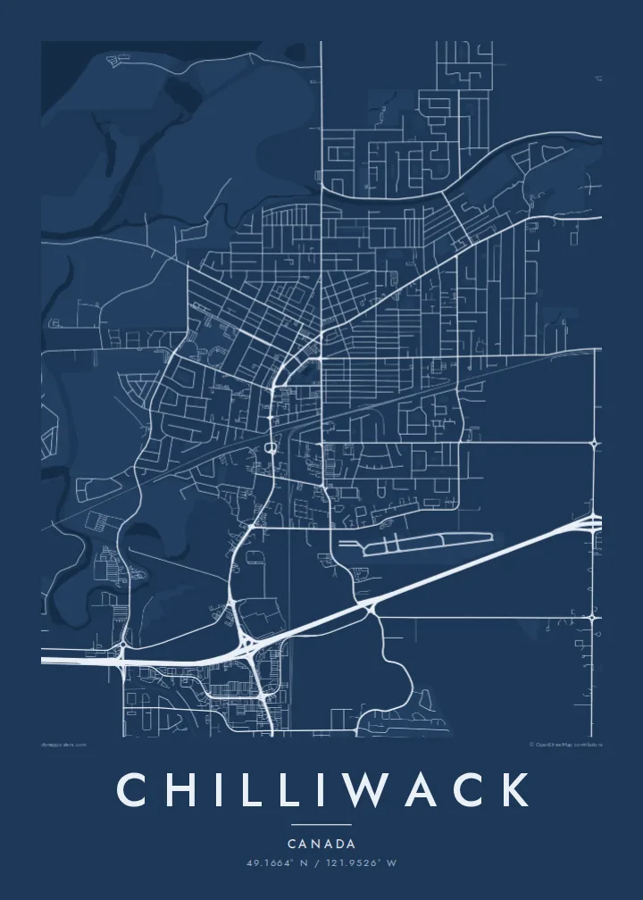
The wide, braided Fraser forms the northern boundary, with sandbars and side channels. It adds a loose, organic edge to an otherwise geometric map.
Fakatino mape mukamuka · Canada
49.1664° N / 121.9526° W
Farm grids on the flat Fraser Valley floor that stop abruptly where the Cascade foothills rise to the south



Taha e taone, lima e onoonoaga
Tapaki e taha puhala ke kitia ai ki luga he puipui. Kua tatai e totogi he tau puhala oti — pete he lolomi, poloka, po ke faila HD.
 Tau pikselo mooli · faila lolomi 24 × 36″
Maama mitaki ke lolomi
Ko e 100% e fahi mooli mai he faila lolomi. Ko e tau poster oti — pete kua lolomi, poloka, po ke utu hifo — kua taute ke he ha mautolu a tau tokoluga (server) ke he 300 DPI, hokotia ke he 7,200 × 10,800 piksela, ke maeke ai e tau ala ikiiki tote ke maaliali fakamitaki he lolomi 24 × 36″.
He Pā


Ko e mape
Chilliwack sits on the floor of the Fraser Valley, about 100 km east of Vancouver. The Fraser River forms the northern edge of the city, and the mountains close in from the south and east. Between them the land is almost perfectly flat. It is divided into long rectangular fields and straight rural roads that look like a ruled page from above.
The urban core is a modest grid around the old downtown, with newer subdivisions spreading toward Sardis and Vedder. The Vedder and Chilliwack rivers come out of the mountains in the south, and Cultus Lake lies in a valley beyond. On the Chilliwack map poster the eye moves from the orderly farmland to the tangle of roads where the valley meets the slopes.
The area is part of the traditional territory of the Stó:lō people, and the name comes from a Halq'eméylem word. Agriculture has shaped the valley for a long time, especially dairy and berry farming. The former Canadian Forces Base Chilliwack has been redeveloped, and its layout is still visible in the southern part of the city.
The wide, braided Fraser forms the northern boundary, with sandbars and side channels. It adds a loose, organic edge to an otherwise geometric map.
Straight roads and field boundaries cover the valley floor in long rectangles. This is the most distinctive texture of the Chilliwack map.
To the south the grid gives way to winding roads and river valleys leading toward Cultus Lake. It shows exactly where the flat land ends.
Taute ke ha hau
Lafi e aho, taha higoa po ke taha kupu haau, hiki e fakatino, lahi po ke tuaga.
Ko e kitiaaga nakai totogi kua tote e maaliali mo e fakamailoga vai. Ko e tau lolomi mo e tau faila HD kua taute ke he 300 DPI, hokotia ke he 7,200 × 10,800 px, nakai fai fakamailoga vai.
Ko e ha Chilliwack
The map is popular with people who live in the valley, including farming families and anyone who has moved out from the coast for more space. It shows the valley as it is: fields, river and mountains in one view.
You can add a family name, a farm name or a moving-in date as the title, and adjust the subtitle and coordinates. Five styles are available: Classic black & white, Noir, Paper, Blueprint and Sand. Sand suits the agricultural setting.
Talaage e poster Chilliwack| Lahi he lolomi | Maama | Tau faila |
|---|---|---|
| 30 × 40 cm11.8 × 15.7″ | 3,543 × 4,724 px | PNG · PDF |
| 29.7 × 42 cm (A3)11.7 × 16.5″ | 3,508 × 4,961 px | PNG · PDF |
| 42 × 59.4 cm (A2)16.5 × 23.4″ | 4,961 × 7,016 px | PNG · PDF |
| 45.7 × 61 cm18 × 24″ | 5,400 × 7,200 px | PNG · PDF |
| 50 × 70 cm19.7 × 27.6″ | 5,906 × 8,268 px | PNG · PDF |
| 61 × 91.4 cm24 × 36″ | 7,200 × 10,800 px | PNG · PDF |
Ke fakatatai, ko e fakatino noa kua 900 px e laulahi, fai fakamailoga mo e mo e tau mata komipiuta ni. Ko e tau faila HD kua ato hoko ke he 8× e maama ke he tau faahi takitaha mo e lolomi mitaki he lahi katoa he fakatino.
Fifili e taha puhala i luga he kupega, ti fifili e Poster Lolomi — e lahi mo e, kaeke ke manako ai koe, taha poloka — po ke Tau Faila HD Fakaeletonika. Ko e fakaotiaga totogi ko e taha gahua ni, ti ko e kupega he hau a talaaga ka fakafou fakahaga i mua he fakaotiaga e totogi.
Kua lolomi ai ke he pepa mitaki 200 gsm matte he taha he tau lahi ono, mai he 30 × 40 cm ke hoko ke he 24 × 36″. Kamata e tau poster lolomi mai he $39, kua putoia ai e utaaga.
E. Fifili e poloka akau malolō ke he lanu uli, tea, akau oki mooli, po ke akau pouli. Kua fakalataha mo e sioga malolō nakai malepe ti kua mautali ke tautau. Kamata e tau poster poloka mai he $99, kua putoia ai e utaaga.
Nakai totogi e fakafano ke he motu 60+. Ko e fakatino taha kua lolomi he fenoga lolomi ha mautolu kua tata mo e tau motu 30+, kua hoko mai he tau aho gahua 3–7. Maeke ia koe ke kikite e tuaga mo e fakamuitua he lalo he Haku Tau Fakatonu. Ke he falu motu kua 2–5 e tau tapu, ti ka nakai fakafano a mautolu ki ai, to fakaha he api tupe ia ki mua he totogi.
Fakafano mai e taha ata ki a mautolu he loto he 14 e tau aho tali mai he hokoaga, ti to lolomi foki e mautolu nakai totogi po ke liu atu e totogi ki a koe.
E. He editor i luga he kupega nei, hikihiki e matakupu, e matakupu lalo mo e laini coordinates ke he taha mena kua manako a koe ki ai, ti fifili e puhala mo e lahi. Ko e tau talaaga lolomi, poloka mo e fakaeletonika oti kua fakaaoga tonu e hau a fakatino.
Ma e $9 ka moua e koe e tau faila PNG 300 DPI mo e PDF kua mautali ke lolomi he tau lahi ono oti, nakai fai fakamailoga vai, ke lolomi i fe mena. Nakai maopoopo agaia? Utu hifo fakamua e kitiaaga nakai totogi ne fai fakamailoga vai.
Tata mai
