Guldborgsund
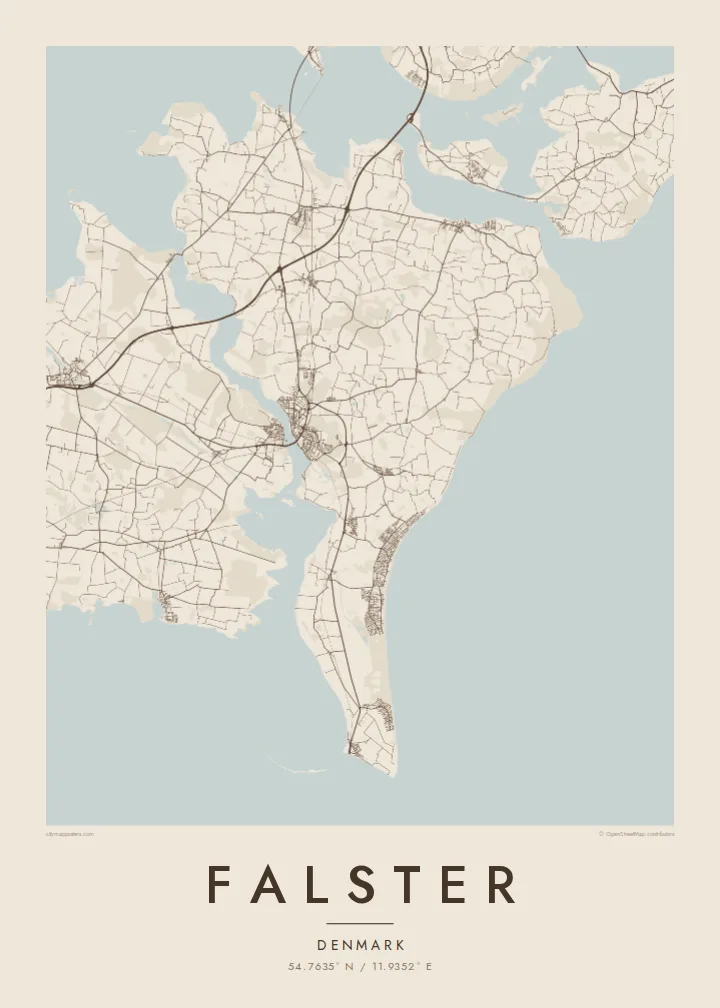
The narrow sound on the west side runs almost the full length of the island. On the map it looks like a river, dividing Falster from Lolland with a thin ribbon of water.
Fakatino mape mukamuka · Denmark
54.7635° N / 11.9352° E
A flat Danish island between Lolland and Zealand, tapering south to Gedser Odde, the country's southernmost point.


Taha e taone, lima e onoonoaga
Tapaki e taha puhala ke kitia ai ki luga he puipui. Kua tatai e totogi he tau puhala oti — pete he lolomi, poloka, po ke faila HD.
 Tau pikselo mooli · faila lolomi 24 × 36″
Maama mitaki ke lolomi
Ko e 100% e fahi mooli mai he faila lolomi. Ko e tau poster oti — pete kua lolomi, poloka, po ke utu hifo — kua taute ke he ha mautolu a tau tokoluga (server) ke he 300 DPI, hokotia ke he 7,200 × 10,800 piksela, ke maeke ai e tau ala ikiiki tote ke maaliali fakamitaki he lolomi 24 × 36″.
He Pā


Ko e mape
Falster lies south of Zealand in the Baltic, a low and fertile island shaped like a wedge that narrows to the south. Its west coast follows the Guldborgsund, a slender sound separating it from Lolland, while the east faces open water with a long, smooth beach. Farmland fills the interior, and the map shows an even spread of country roads between villages.
Nykøbing Falster, the main town, sits on the Guldborgsund, where bridges cross to Lolland. At the northern end, road and railway reach Zealand across the Storstrøm crossing and the Farø bridges. At the southern tip lies Gedser, with its ferry harbour for Rostock and the headland of Gedser Odde, the southernmost point of Denmark.
The east coast is lined with holiday houses around Marielyst, a long stretch of sand popular with Danish families for generations. A Falster map poster brings all of this into one frame: the thin sound to the west, the beach to the east, bridges at the top and a ferry at the bottom, with a quiet agricultural island in between.
The narrow sound on the west side runs almost the full length of the island. On the map it looks like a river, dividing Falster from Lolland with a thin ribbon of water.
The island's main town sits on the sound, its streets gathered around the bridges to Lolland. It is the densest cluster of lines on the poster and its natural centre.
The southern point of the island, and of Denmark, where the land ends in a narrow tip beside the ferry harbour that links the island to Germany.
Taute ke ha hau
Lafi e aho, taha higoa po ke taha kupu haau, hiki e fakatino, lahi po ke tuaga.
Ko e kitiaaga nakai totogi kua tote e maaliali mo e fakamailoga vai. Ko e tau lolomi mo e tau faila HD kua taute ke he 300 DPI, hokotia ke he 7,200 × 10,800 px, nakai fai fakamailoga vai.
Ko e ha Falster
Falster is a summer-house island for many Danes, and a first or last stop for travellers using the Gedser ferry. A map of the whole island captures the drive from the northern bridges down to the beach and the southern tip.
Add the name of a summer house, a family or a year to the title and subtitle, and set the coordinates line. Pick one of five styles, from Classic black & white and Noir to Paper, Blueprint and Sand, as a $9 HD download or a printed poster.
Talaage e poster Falster| Lahi he lolomi | Maama | Tau faila |
|---|---|---|
| 30 × 40 cm11.8 × 15.7″ | 3,543 × 4,724 px | PNG · PDF |
| 29.7 × 42 cm (A3)11.7 × 16.5″ | 3,508 × 4,961 px | PNG · PDF |
| 42 × 59.4 cm (A2)16.5 × 23.4″ | 4,961 × 7,016 px | PNG · PDF |
| 45.7 × 61 cm18 × 24″ | 5,400 × 7,200 px | PNG · PDF |
| 50 × 70 cm19.7 × 27.6″ | 5,906 × 8,268 px | PNG · PDF |
| 61 × 91.4 cm24 × 36″ | 7,200 × 10,800 px | PNG · PDF |
Ke fakatatai, ko e fakatino noa kua 900 px e laulahi, fai fakamailoga mo e mo e tau mata komipiuta ni. Ko e tau faila HD kua ato hoko ke he 8× e maama ke he tau faahi takitaha mo e lolomi mitaki he lahi katoa he fakatino.
Fifili e taha puhala i luga he kupega, ti fifili e Poster Lolomi — e lahi mo e, kaeke ke manako ai koe, taha poloka — po ke Tau Faila HD Fakaeletonika. Ko e fakaotiaga totogi ko e taha gahua ni, ti ko e kupega he hau a talaaga ka fakafou fakahaga i mua he fakaotiaga e totogi.
Kua lolomi ai ke he pepa mitaki 200 gsm matte he taha he tau lahi ono, mai he 30 × 40 cm ke hoko ke he 24 × 36″. Kamata e tau poster lolomi mai he $39, kua putoia ai e utaaga.
E. Fifili e poloka akau malolō ke he lanu uli, tea, akau oki mooli, po ke akau pouli. Kua fakalataha mo e sioga malolō nakai malepe ti kua mautali ke tautau. Kamata e tau poster poloka mai he $99, kua putoia ai e utaaga.
Nakai totogi e fakafano ke he motu 60+. Ko e fakatino taha kua lolomi he fenoga lolomi ha mautolu kua tata mo e tau motu 30+, kua hoko mai he tau aho gahua 3–7. Maeke ia koe ke kikite e tuaga mo e fakamuitua he lalo he Haku Tau Fakatonu. Ke he falu motu kua 2–5 e tau tapu, ti ka nakai fakafano a mautolu ki ai, to fakaha he api tupe ia ki mua he totogi.
Fakafano mai e taha ata ki a mautolu he loto he 14 e tau aho tali mai he hokoaga, ti to lolomi foki e mautolu nakai totogi po ke liu atu e totogi ki a koe.
E. He editor i luga he kupega nei, hikihiki e matakupu, e matakupu lalo mo e laini coordinates ke he taha mena kua manako a koe ki ai, ti fifili e puhala mo e lahi. Ko e tau talaaga lolomi, poloka mo e fakaeletonika oti kua fakaaoga tonu e hau a fakatino.
Ma e $9 ka moua e koe e tau faila PNG 300 DPI mo e PDF kua mautali ke lolomi he tau lahi ono oti, nakai fai fakamailoga vai, ke lolomi i fe mena. Nakai maopoopo agaia? Utu hifo fakamua e kitiaaga nakai totogi ne fai fakamailoga vai.
Tata mai
