Atlantic port
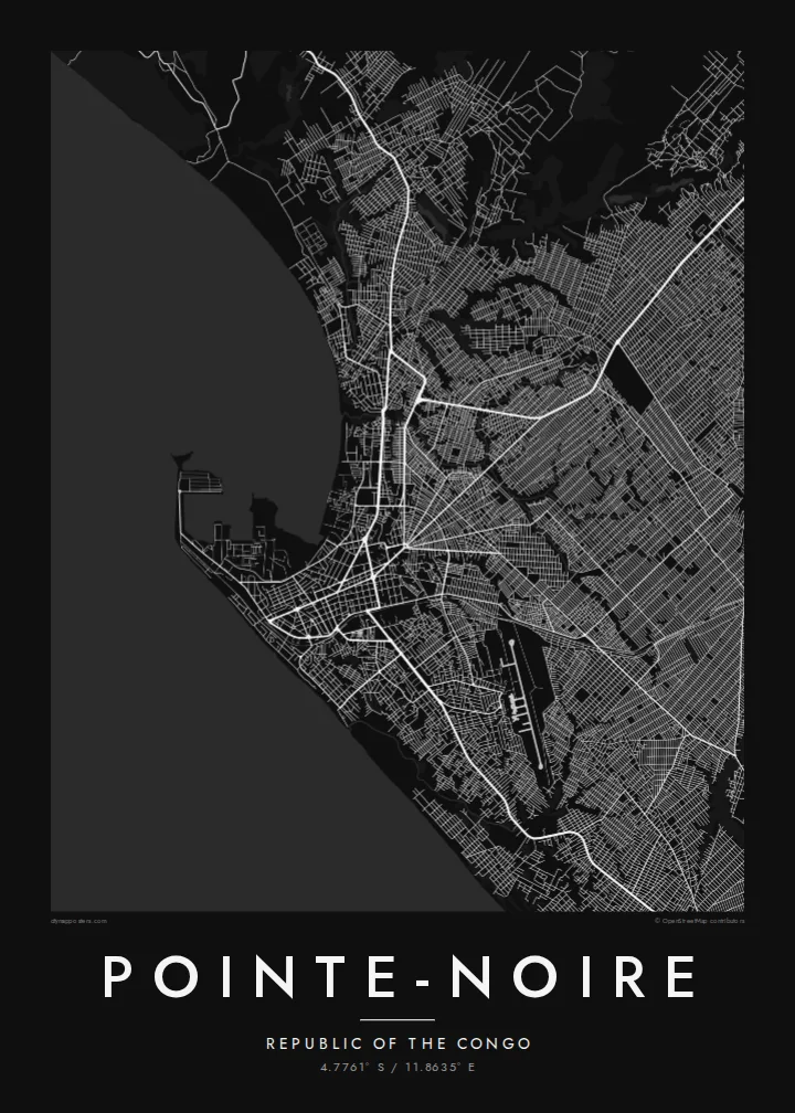
Breakwaters and quays extend into the sea beside the city centre, forming the sharpest geometric shapes on the map and marking the country's main gateway for shipping.
Fakatino mape mukamuka · Congo - Brazzaville
4.7761° S / 11.8635° E
An Atlantic port city on a flat coastal plain, where Congo's railway from the interior meets the sea.



Taha e taone, lima e onoonoaga
Tapaki e taha puhala ke kitia ai ki luga he puipui. Kua tatai e totogi he tau puhala oti — pete he lolomi, poloka, po ke faila HD.
 Tau pikselo mooli · faila lolomi 24 × 36″
Maama mitaki ke lolomi
Ko e 100% e fahi mooli mai he faila lolomi. Ko e tau poster oti — pete kua lolomi, poloka, po ke utu hifo — kua taute ke he ha mautolu a tau tokoluga (server) ke he 300 DPI, hokotia ke he 7,200 × 10,800 piksela, ke maeke ai e tau ala ikiiki tote ke maaliali fakamitaki he lolomi 24 × 36″.
He Pā


Ko e mape
Pointe-Noire is the main seaport of the Republic of the Congo and the country's economic centre, built on a flat coastal plain beside the Atlantic. Its name comes from a dark rocky point that Portuguese sailors noted along the shore. On a map the coastline gives a strong western edge, with the port's breakwaters and quays reaching into the sea near the centre.
The city is the terminus of the Congo-Ocean Railway, built in the 1920s and 1930s to link the coast with Brazzaville, and its railway station remains a well-known landmark. Offshore oil made Pointe-Noire the base of the country's energy industry, and the port handles much of the national trade. Residential districts spread inland in a wide, fairly regular pattern.
A Pointe-Noire map poster frames the city between ocean and plain: the port and beaches along the shore, the straight roads of the older centre and the broad neighbourhoods behind them. It is a clear, legible plan, and the Atlantic coastline stretching away in both directions gives the composition a calm, steady balance.
Breakwaters and quays extend into the sea beside the city centre, forming the sharpest geometric shapes on the map and marking the country's main gateway for shipping.
The Congo-Ocean Railway ends in the heart of the city, and its line heading inland provides a strong route across the map toward Brazzaville, far to the east.
Long sandy beaches follow the shore on either side of the port, a soft edge between the city streets and the open ocean that runs the length of the composition.
Taute ke ha hau
Lafi e aho, taha higoa po ke taha kupu haau, hiki e fakatino, lahi po ke tuaga.
Ko e kitiaaga nakai totogi kua tote e maaliali mo e fakamailoga vai. Ko e tau lolomi mo e tau faila HD kua taute ke he 300 DPI, hokotia ke he 7,200 × 10,800 px, nakai fai fakamailoga vai.
Ko e ha Pointe-Noire
Pointe-Noire is home to many families, to port and oil workers, and to people who spent years in the city before moving on. A map of its coast and streets is a personal reminder of that time and a good fit for an office or a home.
The title, subtitle and coordinates line can be personalised, and you can choose from five styles: Classic black & white, Noir, Paper, Blueprint and Sand. HD files without a watermark are $9, and printed posters ship from partners in more than 30 countries.
Talaage e poster Pointe-Noire| Lahi he lolomi | Maama | Tau faila |
|---|---|---|
| 30 × 40 cm11.8 × 15.7″ | 3,543 × 4,724 px | PNG · PDF |
| 29.7 × 42 cm (A3)11.7 × 16.5″ | 3,508 × 4,961 px | PNG · PDF |
| 42 × 59.4 cm (A2)16.5 × 23.4″ | 4,961 × 7,016 px | PNG · PDF |
| 45.7 × 61 cm18 × 24″ | 5,400 × 7,200 px | PNG · PDF |
| 50 × 70 cm19.7 × 27.6″ | 5,906 × 8,268 px | PNG · PDF |
| 61 × 91.4 cm24 × 36″ | 7,200 × 10,800 px | PNG · PDF |
Ke fakatatai, ko e fakatino noa kua 900 px e laulahi, fai fakamailoga mo e mo e tau mata komipiuta ni. Ko e tau faila HD kua ato hoko ke he 8× e maama ke he tau faahi takitaha mo e lolomi mitaki he lahi katoa he fakatino.
Fifili e taha puhala i luga he kupega, ti fifili e Poster Lolomi — e lahi mo e, kaeke ke manako ai koe, taha poloka — po ke Tau Faila HD Fakaeletonika. Ko e fakaotiaga totogi ko e taha gahua ni, ti ko e kupega he hau a talaaga ka fakafou fakahaga i mua he fakaotiaga e totogi.
Kua lolomi ai ke he pepa mitaki 200 gsm matte he taha he tau lahi ono, mai he 30 × 40 cm ke hoko ke he 24 × 36″. Kamata e tau poster lolomi mai he $39, kua putoia ai e utaaga.
E. Fifili e poloka akau malolō ke he lanu uli, tea, akau oki mooli, po ke akau pouli. Kua fakalataha mo e sioga malolō nakai malepe ti kua mautali ke tautau. Kamata e tau poster poloka mai he $99, kua putoia ai e utaaga.
Nakai totogi e fakafano ke he motu 60+. Ko e fakatino taha kua lolomi he fenoga lolomi ha mautolu kua tata mo e tau motu 30+, kua hoko mai he tau aho gahua 3–7. Maeke ia koe ke kikite e tuaga mo e fakamuitua he lalo he Haku Tau Fakatonu. Ke he falu motu kua 2–5 e tau tapu, ti ka nakai fakafano a mautolu ki ai, to fakaha he api tupe ia ki mua he totogi.
Fakafano mai e taha ata ki a mautolu he loto he 14 e tau aho tali mai he hokoaga, ti to lolomi foki e mautolu nakai totogi po ke liu atu e totogi ki a koe.
E. He editor i luga he kupega nei, hikihiki e matakupu, e matakupu lalo mo e laini coordinates ke he taha mena kua manako a koe ki ai, ti fifili e puhala mo e lahi. Ko e tau talaaga lolomi, poloka mo e fakaeletonika oti kua fakaaoga tonu e hau a fakatino.
Ma e $9 ka moua e koe e tau faila PNG 300 DPI mo e PDF kua mautali ke lolomi he tau lahi ono oti, nakai fai fakamailoga vai, ke lolomi i fe mena. Nakai maopoopo agaia? Utu hifo fakamua e kitiaaga nakai totogi ne fai fakamailoga vai.
Tata mai
