Kamanashi River
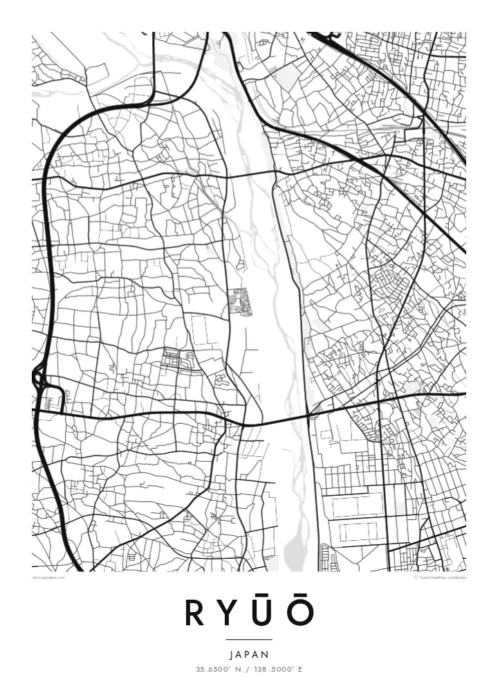
A broad river channel runs along the western side of Ryūō. Its wide, braided bed contrasts with the small blocks of houses next to it.
Fakatino mape mukamuka · Japan
35.6500° N / 138.5000° E
A flat district on the floor of the Kōfu Basin, crossed by a railway and edged by an old river levee


Taha e taone, lima e onoonoaga
Tapaki e taha puhala ke kitia ai ki luga he puipui. Kua tatai e totogi he tau puhala oti — pete he lolomi, poloka, po ke faila HD.
 Tau pikselo mooli · faila lolomi 24 × 36″
Maama mitaki ke lolomi
Ko e 100% e fahi mooli mai he faila lolomi. Ko e tau poster oti — pete kua lolomi, poloka, po ke utu hifo — kua taute ke he ha mautolu a tau tokoluga (server) ke he 300 DPI, hokotia ke he 7,200 × 10,800 piksela, ke maeke ai e tau ala ikiiki tote ke maaliali fakamitaki he lolomi 24 × 36″.
He Pā


Ko e mape
Ryūō is in the western part of the Kōfu Basin in Yamanashi Prefecture. It was once a town of its own and is now part of the city of Kai. The land here is almost completely flat, surrounded by mountain ranges on all sides, and on a map the flatness shows as a close mix of houses, roads and remaining farmland.
The Chūō Main Line passes through, with a station named Ryūō, and the Kamanashi River lies along the western side. This stretch of river is linked with the Shingen Tsutsumi, a flood-control levee traditionally credited to the warlord Takeda Shingen. It is one of the best-known early engineering projects in Japan, and the river and levee give the map a strong edge on one side.
A Ryūō map poster shows a quiet part of the basin, on a map with few landmarks and a lot of fine texture. Smaller streets wind between plots, and larger roads cut straight across them. The result looks almost like an engraving in monochrome. Looking toward the south, the basin is also known for its views of Mount Fuji.
A broad river channel runs along the western side of Ryūō. Its wide, braided bed contrasts with the small blocks of houses next to it.
The historic levee system along the Kamanashi is traditionally linked with Takeda Shingen. It is a notable piece of flood engineering in this part of the basin.
The railway cuts a straight line across the district, and Ryūō Station sits on it. It is one of the few long, clean lines in an otherwise closely packed map.
Taute ke ha hau
Lafi e aho, taha higoa po ke taha kupu haau, hiki e fakatino, lahi po ke tuaga.
Ko e kitiaaga nakai totogi kua tote e maaliali mo e fakamailoga vai. Ko e tau lolomi mo e tau faila HD kua taute ke he 300 DPI, hokotia ke he 7,200 × 10,800 px, nakai fai fakamailoga vai.
Ko e ha Ryūō
For people from Yamanashi, Ryūō is a specific home rather than just a point on the way to Kōfu. A drawing of its streets, the river and the railway keeps that specific place on the wall. It suits a calm interior, where fine lines can be looked at up close.
Add a title in Latin or Japanese script, a subtitle or a special date, and edit the coordinates line if you wish. Choose Classic black & white, Noir, Paper, Blueprint or Sand. HD files are $9, and a free 900 px preview shows the result before you buy.
Talaage e poster Ryūō| Lahi he lolomi | Maama | Tau faila |
|---|---|---|
| 30 × 40 cm11.8 × 15.7″ | 3,543 × 4,724 px | PNG · PDF |
| 29.7 × 42 cm (A3)11.7 × 16.5″ | 3,508 × 4,961 px | PNG · PDF |
| 42 × 59.4 cm (A2)16.5 × 23.4″ | 4,961 × 7,016 px | PNG · PDF |
| 45.7 × 61 cm18 × 24″ | 5,400 × 7,200 px | PNG · PDF |
| 50 × 70 cm19.7 × 27.6″ | 5,906 × 8,268 px | PNG · PDF |
| 61 × 91.4 cm24 × 36″ | 7,200 × 10,800 px | PNG · PDF |
Ke fakatatai, ko e fakatino noa kua 900 px e laulahi, fai fakamailoga mo e mo e tau mata komipiuta ni. Ko e tau faila HD kua ato hoko ke he 8× e maama ke he tau faahi takitaha mo e lolomi mitaki he lahi katoa he fakatino.
Fifili e taha puhala i luga he kupega, ti fifili e Poster Lolomi — e lahi mo e, kaeke ke manako ai koe, taha poloka — po ke Tau Faila HD Fakaeletonika. Ko e fakaotiaga totogi ko e taha gahua ni, ti ko e kupega he hau a talaaga ka fakafou fakahaga i mua he fakaotiaga e totogi.
Kua lolomi ai ke he pepa mitaki 200 gsm matte he taha he tau lahi ono, mai he 30 × 40 cm ke hoko ke he 24 × 36″. Kamata e tau poster lolomi mai he $39, kua putoia ai e utaaga.
E. Fifili e poloka akau malolō ke he lanu uli, tea, akau oki mooli, po ke akau pouli. Kua fakalataha mo e sioga malolō nakai malepe ti kua mautali ke tautau. Kamata e tau poster poloka mai he $99, kua putoia ai e utaaga.
Nakai totogi e fakafano ke he motu 60+. Ko e fakatino taha kua lolomi he fenoga lolomi ha mautolu kua tata mo e tau motu 30+, kua hoko mai he tau aho gahua 3–7. Maeke ia koe ke kikite e tuaga mo e fakamuitua he lalo he Haku Tau Fakatonu. Ke he falu motu kua 2–5 e tau tapu, ti ka nakai fakafano a mautolu ki ai, to fakaha he api tupe ia ki mua he totogi.
Fakafano mai e taha ata ki a mautolu he loto he 14 e tau aho tali mai he hokoaga, ti to lolomi foki e mautolu nakai totogi po ke liu atu e totogi ki a koe.
E. He editor i luga he kupega nei, hikihiki e matakupu, e matakupu lalo mo e laini coordinates ke he taha mena kua manako a koe ki ai, ti fifili e puhala mo e lahi. Ko e tau talaaga lolomi, poloka mo e fakaeletonika oti kua fakaaoga tonu e hau a fakatino.
Ma e $9 ka moua e koe e tau faila PNG 300 DPI mo e PDF kua mautali ke lolomi he tau lahi ono oti, nakai fai fakamailoga vai, ke lolomi i fe mena. Nakai maopoopo agaia? Utu hifo fakamua e kitiaaga nakai totogi ne fai fakamailoga vai.
Tata mai
