Lake Pichola
The irregular lake with its islands, including the Lake Palace and Jag Mandir, dominates the western side of the historic city.
Minimalist map poster · India
A city of lakes in the Aravalli hills, its old walled core pressed against the shore of Lake Pichola
24.5858° N / 73.7135° E


One city, five moods
Tap a style to see it on the wall. Every style is included in the same $9 price.
 Actual pixels · 24 × 36″ HD file
Print-sharp
This is a crop of the real HD file at 100%. The paid download is rendered on our servers at 300 DPI, up to 7,200 × 10,800 pixels, so even the smallest lanes stay crisp on a 24 × 36″ print.
The map
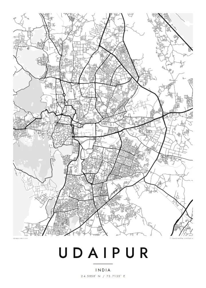
Udaipur lies in southern Rajasthan among the Aravalli hills, and its map is shaped by water. Lake Pichola lies along the west of the old city, with Fateh Sagar Lake to the north, linked by channels. The walled old city is a maze of narrow lanes climbing from the lakeshore, while newer districts spread east and north across flatter ground.
The city was founded in 1559 by Maharana Udai Singh II as the new capital of Mewar. Its City Palace rises along the eastern shore of Lake Pichola, facing the Lake Palace and Jag Mandir on their islands. Udaipur is widely known as the City of Lakes.
A Udaipur map poster shows one of India's most distinctive urban forms: irregular lake outlines, islands, ghats and a dense old-city web of lanes, surrounded by hills that push the roads into curves. In black and white the lakes read as calm open shapes, and the old city around them looks almost hand-drawn.
The irregular lake with its islands, including the Lake Palace and Jag Mandir, dominates the western side of the historic city.
Inside the historic walls, narrow winding streets climb from the ghats toward the City Palace and Jagdish Temple area in a dense, organic pattern.
North of Pichola, this second large lake with its small islands and lakeside road forms another clear open shape on the map.
Make it yours
Add a date, a name or a line of your own, switch style, size or orientation.
Free preview is low-resolution with a watermark. The HD version is 7,200 × 10,800 px, 300 DPI, no watermark.
Why Udaipur
Udaipur is a place of weddings, honeymoons and unforgettable trips, as well as home for generations of families. A map of its lakes and lanes is an elegant way to mark a celebration or keep hometown streets close.
Add your own title, subtitle and coordinates, such as a wedding date by the lake. Choose from Classic black & white, Noir, Paper, Blueprint or Sand, and download 300 DPI files for $9 or order a printed poster with optional wooden frame.
Get the Udaipur poster — $9| Print size | Resolution | Files |
|---|---|---|
| 30 × 40 cm | 3,543 × 4,724 px | PNG · PDF |
| 50 × 70 cm | 5,906 × 8,268 px | PNG · PDF |
| A3 · 29.7 × 42 cm | 3,508 × 4,961 px | PNG · PDF |
| A2 · 42 × 59.4 cm | 4,961 × 7,016 px | PNG · PDF |
| 18 × 24" | 5,400 × 7,200 px | PNG · PDF |
| 24 × 36" | 7,200 × 10,800 px | PNG · PDF |
For comparison, the free preview is 900 px wide, watermarked and meant for screens. The HD files have up to 8× the resolution in each direction and print cleanly at full poster size.
Yes. Drag and zoom the map in the editor — centre it on your neighbourhood, the old town or the whole metro area. The text updates independently.
The HD purchase includes 30×40 cm, 50×70 cm, A3, A2, 18×24″ and 24×36″, each as a 300 DPI PNG and a print-ready PDF.
You can download a free 900 px preview with a watermark. The paid HD files have no watermark and are sharp enough for large prints.
Send the PDF to any local print shop or online printing service and ask for the matching paper size. Matte paper and a thin black or oak frame suit this style best.
Nearby
