Turia Gardens
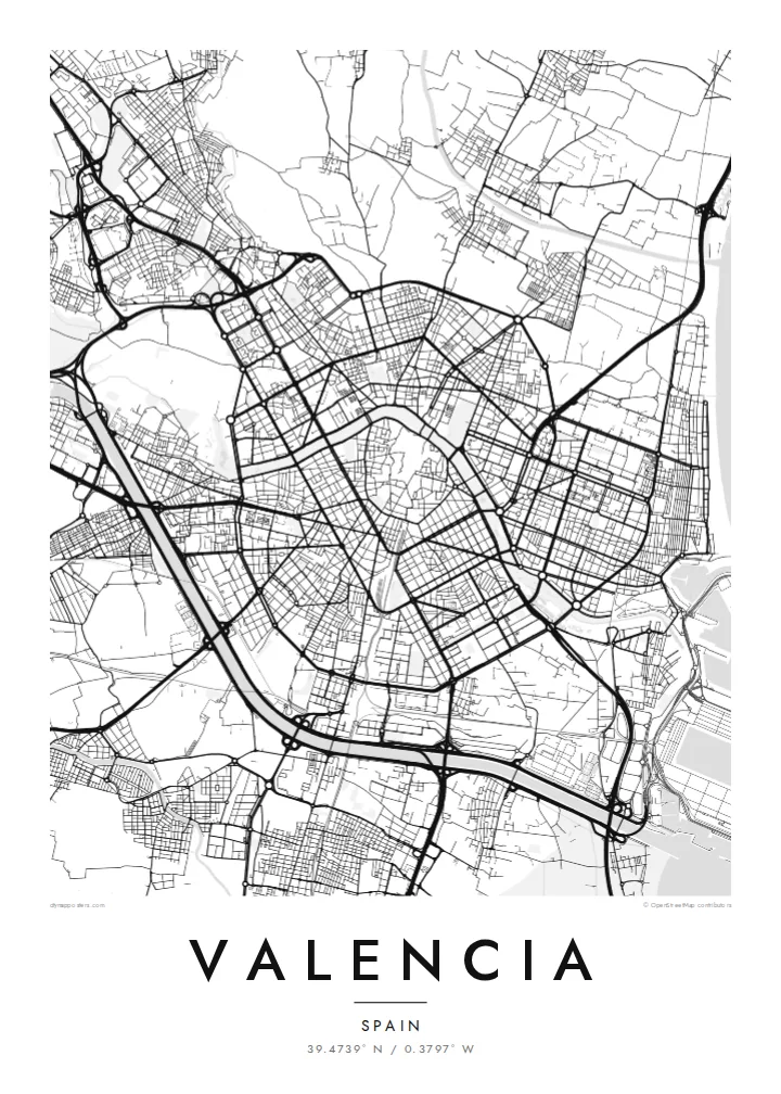
The former riverbed forms a continuous park of roughly nine kilometres, spanned by historic bridges. In black and white it becomes the curve that defines the whole composition.
Minimalist map poster · Spain
39.4739° N / 0.3797° W
A round old town, a dry riverbed turned into a nine-kilometre garden, and a straight run of streets down to the sea


One city, five moods
Tap a style to see it on the wall. Every style costs the same — printed, framed or as HD files.
 Actual pixels · 24 × 36″ print file
Print-sharp
This is a 100% crop of the real print file. Every poster — printed, framed or downloaded — is rendered on our servers at 300 DPI, up to 7,200 × 10,800 pixels, so even the smallest lanes stay crisp on a 24 × 36″ print.
On the wall


The map
From above, Valencia is organised around a river that no longer runs through it. After the flood of 1957 the Turia was diverted south of the city, and its old bed became a long green ribbon. It curves around the historic centre and carries on towards the port. On a map it reads as a smooth arc of park crossed by old stone bridges, dividing the dense quarters to the north from the rest.
The Ciutat Vella sits inside that curve as a near-circular knot of narrow lanes. Its outline is traced by the boulevards that replaced the medieval walls. Beyond them the nineteenth-century Eixample lays down a tidier grid. Further east the streets stretch toward the harbour, the Malvarrosa beach and the white forms of the City of Arts and Sciences at the far end of the garden.
South of the city the land opens into rice fields around the Albufera lagoon, the landscape that gave the world paella. A Valencia map poster usually frames the centre and the riverbed together, so the eye can follow the green line from the old gates at Serranos and Quart all the way to the coast.
The former riverbed forms a continuous park of roughly nine kilometres, spanned by historic bridges. In black and white it becomes the curve that defines the whole composition.
The old town's rounded boundary follows the line of walls that are now gone, with a tight mesh of lanes inside and the cathedral quarter near its centre.
East of the centre the grid runs out to the harbour basins and a long straight beachfront, giving the map a firm edge along the Mediterranean.
Make it yours
Add a date, a name or a line of your own, switch style, size or orientation.
The free preview is low-resolution with a watermark. Prints and HD files are rendered at 300 DPI, up to 7,200 × 10,800 px, without a watermark.
Why Valencia
Valencia tends to stay with people who have lived there, studied there or spent a long summer by the sea. The map holds the whole city in one view: the old core, the green arc around it and the streets reaching out toward the water.
You can set your own title, subtitle and coordinates line, perhaps with a neighbourhood or a year, and choose from Classic black & white, Noir, Paper, Blueprint or Sand. The HD files cost $9, or you can order a matte print with an optional wooden frame.
Order the Valencia poster| Print size | Resolution | Files |
|---|---|---|
| 30 × 40 cm11.8 × 15.7″ | 3,543 × 4,724 px | PNG · PDF |
| 29.7 × 42 cm (A3)11.7 × 16.5″ | 3,508 × 4,961 px | PNG · PDF |
| 42 × 59.4 cm (A2)16.5 × 23.4″ | 4,961 × 7,016 px | PNG · PDF |
| 45.7 × 61 cm18 × 24″ | 5,400 × 7,200 px | PNG · PDF |
| 50 × 70 cm19.7 × 27.6″ | 5,906 × 8,268 px | PNG · PDF |
| 61 × 91.4 cm24 × 36″ | 7,200 × 10,800 px | PNG · PDF |
For comparison, the free preview is 900 px wide, watermarked and meant for screens. The HD files have up to 8× the resolution in each direction and print cleanly at full poster size.
Pick a style at the top of the page, then choose Printed Poster — a size and, if you like, a frame — or Digital HD Files. Checkout takes one step, and your order page updates as soon as the payment goes through.
It is printed on premium 200 gsm matte paper in one of six sizes, from 30 × 40 cm to 24 × 36″. Printed posters start at $39, shipping included.
Yes. Choose a solid wood frame in black, white, natural oak or dark wood. It comes with shatterproof glazing and is ready to hang. Framed posters start at $99, shipping included.
Shipping is free to 60+ countries. Each poster is printed by the nearest of our print partners in 30+ countries and usually arrives in 3–7 business days. You can follow the status and tracking under My Orders. A few countries take 2–5 weeks, and where we don't ship yet, the site tells you before you pay.
Send us a photo within 14 days of delivery and we will reprint it for free or refund you.
Yes. In the editor on this page, change the title, the subtitle and the coordinates line to anything you like, and pick a style and size. Printed, framed and digital orders all use exactly your design.
For $9 you get 300 DPI PNG and print-ready PDF files in all six sizes, without a watermark, to print anywhere. Not sure yet? Download a free watermarked preview first.
Nearby
