Mississippi bend
The river sweeps along the town's northern edge in a wide arc, its banks lined with the levee, wharves and industrial sites that face the shipping channel.
Ata mapa faigafua · United States
29.9430° N / 89.9654° W
A riverside grid on the Mississippi's east bank, levee on one side and wetlands opening toward the Gulf on the other


Kolo e tahi, lanu e nima
Tuki he sitaili ke sio ai ʻi te holo. ʻE tatau pē te totogi ʻo te sitaili fuli pē — mokā tā, fakakātoa, peʻe ko he ʻu faila HD.
 Ngaahi pikiseli moʻoni · faila tā 24 × 36″
Mahino lelei ki te pulūti
Ko he konga 100% ʻo te faila tā moʻoni ʻaeni. Ko te ʻu posita fuli pē — mokā tā, fakakātoa peʻe download — ʻe fakatupu ʻi ʻomātou seva ʻi te 300 DPI, aʻu ki te 7,200 × 10,800 pikiseli, koia ʻe nofo mahino ai te ʻu ala liliki ʻi he tā 24 × 36″.
ʻI Te Puipui


Te mapa
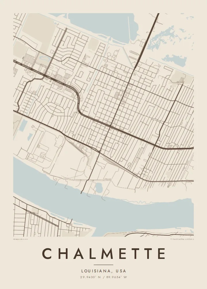
Chalmette lies just downriver from New Orleans in St. Bernard Parish, on a strip of higher ground along the east bank of the Mississippi. On a map the river curves across the top of the town, lined by the levee and industrial frontage. Behind it, a regular grid of residential streets fills the land between the river and the marshes that stretch away toward the east.
The town is best known as the site of the Battle of New Orleans in January 1815. The battlefield, now part of Jean Lafitte National Historical Park and Preserve, sits beside the river as an open rectangle of land, clearly visible among the surrounding blocks. The same low ground made Chalmette one of the places hit hardest by the flooding after Hurricane Katrina in 2005.
A Chalmette map poster shows how closely life here depends on water. The broad bend of the river, the straight canals and drainage lines, and the grid that stops at the wetland edge together describe a place defined by elevation measured in feet. In monochrome that relationship is easy to read at a glance.
The river sweeps along the town's northern edge in a wide arc, its banks lined with the levee, wharves and industrial sites that face the shipping channel.
The 1815 battlefield is an open, rectangular green by the river. On the poster it appears as a calm gap among the streets, with the national cemetery next to it.
Residential blocks run in an orderly grid until they meet canals and wetlands. That boundary between built land and open water gives the map its character.
Faʻu ke ʻau ʻa ʻau
Tuku he ʻaho, he hingoa peʻe he kiʻi palalau ʻa ʻau, fetogi te faʻahiga, te lahi peʻe te hake.
Ko te faʻata fua noa ʻe māʻulalo hono lelei pea ʻe ʻi ai he fakaʻilonga. Ko te ʻu tā mo te ʻu faila HD ʻe fakatupu ʻi te 300 DPI, aʻu ki te 7,200 × 10,800 px, ʻe mole ʻi ai he fakaʻilonga.
Koteā ko Chalmette
For people from St. Bernard Parish, Chalmette often stands for family history, rebuilding after the storm and a strong sense of home. A map of the streets people returned to can mean more than any photograph, especially for families now spread across the South.
Personalise the title, subtitle and coordinates line with a family name, a street or a meaningful year. Then choose one of five styles: Classic black & white, Noir, Paper, Blueprint or Sand. Noir makes the river and the wetlands particularly striking.
Fakatau te posita Chalmette| Lahi ʻo te pulūti | Mahino | Faile |
|---|---|---|
| 30 × 40 cm11.8 × 15.7″ | 3,543 × 4,724 px | PNG · PDF |
| 29.7 × 42 cm (A3)11.7 × 16.5″ | 3,508 × 4,961 px | PNG · PDF |
| 42 × 59.4 cm (A2)16.5 × 23.4″ | 4,961 × 7,016 px | PNG · PDF |
| 45.7 × 61 cm18 × 24″ | 5,400 × 7,200 px | PNG · PDF |
| 50 × 70 cm19.7 × 27.6″ | 5,906 × 8,268 px | PNG · PDF |
| 61 × 91.4 cm24 × 36″ | 7,200 × 10,800 px | PNG · PDF |
Ko te ata ʻe mole totogi ʻe 900 px tona laulahi, mo te fakaʻilonga, ki te sioʻata pē. Ko te ʻu faile HD ʻe aʻu ki te liuga 8 tona mahino, pea ʻe pulūti lelei ʻi te lahi kātoa.
Fili he sitaili ʻi te tuʻa ʻo te pasina, pea fili leva te Posita Tā — he lahi pea, kapau ʻe ke loto ai, he fakakātoa — peʻe ko te ʻu Faila HD Fakakomipiuta. ʻE tahi pē te sitepu ʻo te totogi, pea ʻe fakafou fakavavevave pē tau pasina fakatau mai te taimi ʻe fai ai te totogi.
ʻE tā ʻi he pepa lelei ʻaupito 200 gsm matte, ʻi he tahi ʻo te ono lahi, mai te 30 × 40 cm ki te 24 × 36″. ʻE kamata te ʻu posita tā ʻi te $39, kātoa mo te ʻave.
ʻIo. Fili he fakakātoa ʻakau moʻoni ʻi te kili, hinahina, ʻakau natula peʻe ʻakau ʻuliʻuli. ʻE ʻi ai mo he sioga mālohi ʻe mole mafesi, pea kua teu ke tautau. ʻE kamata te ʻu posita fakakātoa ʻi te $99, kātoa mo te ʻave.
Ko te fakahoko e mole totogi ki te ʼu fenua e 60+. Ko te pōsita taki taha ʼe tā e te tahi ʼo ʼemau ʼu kaufakalogo tā ʼe ofi mai, ʼi te ʼu fenua e 30+, pea ʼe hoko mai ʼi te ʼu ʼaho gaue e 3–7. ʼE feala hau ke ke vakaʼi te tuʼunga mo te tracking ʼi Oku Fakamaʼu. ʼE ʼi ai te ʼu fenua ʼe 2–5 te ʼu vaiaho, pea ʼi te ʼu fenua ʼaē ʼe heʼeki tou fakahoko ki ai, ʼe fakahā e te saite ʼi muʼa ʼo tau totogi.
Fekau mai he ʻata ʻi loto ʻi te ʻaho e 14 talu mai te aʻu mai, pea mātou toe tā noa peʻe toe totogi atu.
ʻIo. ʻI te meʻa fakatonutonu ʻi te pasina ʻaeni, fetogi te kupu tāfito, te kupu lalo pea mo te laina koʻoliteti ki he meʻa fuli pē ʻe ke loto ai, pea fili he sitaili mo he lahi. Ko te ʻu fakatau tā, fakakātoa mo fakakomipiuta ʻe fakaʻaogaʻi katoa pē tou fakatātā.
Mo te $9 ʻe ke maʻu ai te ʻu faila PNG 300 DPI mo PDF kua teu ke tā, ʻi te ono lahi kātoa, ʻe mole ʻi ai he fakaʻilonga, ke ke tā ai ʻi soʻo he potu. Kei tā fakafiafia? Download muʻa he faʻata mokā mo he fakaʻilonga, ʻe fua noa.
