The Gond ramparts
The historic wall and its gates still shape the street pattern, leaving a clear ring of older, tighter lanes at the centre of the modern city.
Ata mapa faigafua · India
19.9508° N / 79.2952° E
An old walled town between two small rivers, its stone circuit still traced by roads that loop the historic core.


Kolo e tahi, lanu e nima
Tuki he sitaili ke sio ai ʻi te holo. ʻE tatau pē te totogi ʻo te sitaili fuli pē — mokā tā, fakakātoa, peʻe ko he ʻu faila HD.
 Ngaahi pikiseli moʻoni · faila tā 24 × 36″
Mahino lelei ki te pulūti
Ko he konga 100% ʻo te faila tā moʻoni ʻaeni. Ko te ʻu posita fuli pē — mokā tā, fakakātoa peʻe download — ʻe fakatupu ʻi ʻomātou seva ʻi te 300 DPI, aʻu ki te 7,200 × 10,800 pikiseli, koia ʻe nofo mahino ai te ʻu ala liliki ʻi he tā 24 × 36″.
ʻI Te Puipui


Te mapa
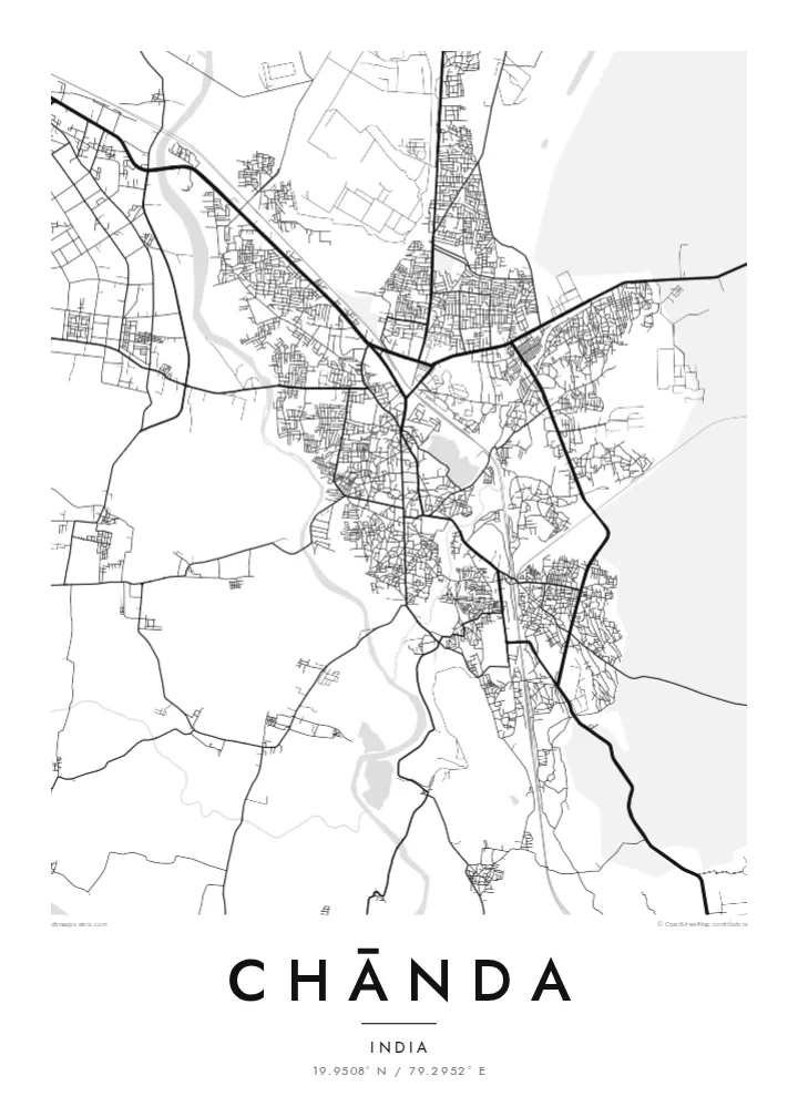
Chānda, officially Chandrapur, grew up inside a long stone wall built under the Gond kings who ruled this part of eastern Maharashtra. On a map the old town still shows that outline: a rough loop of roads following the line of the ramparts, with gateways where traffic squeezes through and denser lanes packed inside. Newer districts spread outward in looser blocks on every side.
Water frames the town to the west and east. The Erai River runs down its western edge and the smaller Zarpat stream passes the eastern side, so the built-up area sits on the higher ground between two thin blue lines. Rail tracks and highways cut across the plain, and broad industrial sites mark the power station and coal workings that made the district's name.
A Chānda map poster reduces all of this to line and space: the curve of the old wall, the river channels, the rail spur and the grid of the newer colonies. Beyond the frame lies the teak forest of Tadoba-Andhari Tiger Reserve, one of Maharashtra's best-known wildlife areas, which gives the town a reputation that reaches well past its coal and cement.
The historic wall and its gates still shape the street pattern, leaving a clear ring of older, tighter lanes at the centre of the modern city.
The Erai runs along the western side of town, a narrow river line that gives the map a firm boundary and a sense of direction.
Large rectangular footprints of the thermal power station and mining areas sit on the fringes, contrasting sharply with the fine grain of the old town.
Faʻu ke ʻau ʻa ʻau
Tuku he ʻaho, he hingoa peʻe he kiʻi palalau ʻa ʻau, fetogi te faʻahiga, te lahi peʻe te hake.
Ko te faʻata fua noa ʻe māʻulalo hono lelei pea ʻe ʻi ai he fakaʻilonga. Ko te ʻu tā mo te ʻu faila HD ʻe fakatupu ʻi te 300 DPI, aʻu ki te 7,200 × 10,800 px, ʻe mole ʻi ai he fakaʻilonga.
Koteā ko Chānda
People from Chandrapur often carry the old town in their heads as a set of gates and turns. A framed map puts that memory on the wall, whether it marks a family home, a first posting, or a stop on the way to the tiger reserve.
The title, subtitle and coordinates line can be changed to a name, a date or a phrase. Choose Classic black & white, Noir, Paper, Blueprint or Sand, download the HD files for $9, or order a matte print with an optional wooden frame.
Fakatau te posita Chānda| Lahi ʻo te pulūti | Mahino | Faile |
|---|---|---|
| 30 × 40 cm (11.8 × 15.7″) | 3,543 × 4,724 px | PNG · PDF |
| 29.7 × 42 cm (A3, 11.7 × 16.5″) | 3,508 × 4,961 px | PNG · PDF |
| 42 × 59.4 cm (A2, 16.5 × 23.4″) | 4,961 × 7,016 px | PNG · PDF |
| 45.7 × 61 cm (18 × 24″) | 5,400 × 7,200 px | PNG · PDF |
| 50 × 70 cm (19.7 × 27.6″) | 5,906 × 8,268 px | PNG · PDF |
| 61 × 91.4 cm (24 × 36″) | 7,200 × 10,800 px | PNG · PDF |
Ko te ata ʻe mole totogi ʻe 900 px tona laulahi, mo te fakaʻilonga, ki te sioʻata pē. Ko te ʻu faile HD ʻe aʻu ki te liuga 8 tona mahino, pea ʻe pulūti lelei ʻi te lahi kātoa.
Fili he sitaili ʻi te tuʻa ʻo te pasina, pea fili leva te Posita Tā — he lahi pea, kapau ʻe ke loto ai, he fakakātoa — peʻe ko te ʻu Faila HD Fakakomipiuta. ʻE tahi pē te sitepu ʻo te totogi, pea ʻe fakafou fakavavevave pē tau pasina fakatau mai te taimi ʻe fai ai te totogi.
ʻE tā ʻi he pepa lelei ʻaupito 200 gsm matte, ʻi he tahi ʻo te ono lahi, mai te 30 × 40 cm ki te 24 × 36″. ʻE kamata te ʻu posita tā ʻi te {printFrom}, kātoa mo te ʻave.
ʻIo. Fili he fakakātoa ʻakau moʻoni ʻi te kili, hinahina, ʻakau natula peʻe ʻakau ʻuliʻuli. ʻE ʻi ai mo he sioga mālohi ʻe mole mafesi, pea kua teu ke tautau. ʻE kamata te ʻu posita fakakātoa ʻi te {framedFrom}, kātoa mo te ʻave.
ʻE fua noa te ʻave ki te lalolagi kātoa. ʻE tā takitaha posita e te kaugā tā ʻe ovi ki ai ʻi te lolotoga ʻo te ʻu puleʻanga e 30 tupu, pea ʻe aʻu mai tuʻumaʻu ʻi te ʻaho gāue e 3 ki te 7. ʻE feala ke ke sio ki te tuʻu pea mo te ʻalu ʻi lalo ʻo Taku ʻu Fakatau.
Fekau mai he ʻata ʻi loto ʻi te ʻaho e 14 talu mai te aʻu mai, pea mātou toe tā noa peʻe toe totogi atu.
ʻIo. ʻI te meʻa fakatonutonu ʻi te pasina ʻaeni, fetogi te kupu tāfito, te kupu lalo pea mo te laina koʻoliteti ki he meʻa fuli pē ʻe ke loto ai, pea fili he sitaili mo he lahi. Ko te ʻu fakatau tā, fakakātoa mo fakakomipiuta ʻe fakaʻaogaʻi katoa pē tou fakatātā.
Mo te $9 ʻe ke maʻu ai te ʻu faila PNG 300 DPI mo PDF kua teu ke tā, ʻi te ono lahi kātoa, ʻe mole ʻi ai he fakaʻilonga, ke ke tā ai ʻi soʻo he potu. Kei tā fakafiafia? Download muʻa he faʻata mokā mo he fakaʻilonga, ʻe fua noa.
