Mittelland Canal
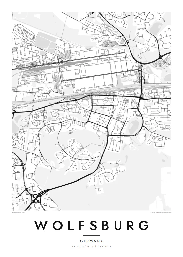
The canal crosses the city in a nearly straight line, separating the factory from the town and forming the strongest single stroke on the map.
Minimalist map poster · Germany
52.4236° N / 10.7760° E
A planned industrial town laid out along the Mittelland Canal, facing one of the world's largest car factories across the water.
One city, five moods
Tap a style to see it on the wall. Every style costs the same — printed, framed or as HD files.
 Actual pixels · 24 × 36″ print file
Print-sharp
This is a 100% crop of the real print file. Every poster — printed, framed or downloaded — is rendered on our servers at 300 DPI, up to 7,200 × 10,800 pixels, so even the smallest lanes stay crisp on a 24 × 36″ print.
On the wall


The map
Wolfsburg was founded in 1938 as a new town for the Volkswagen works, and its map still reads like a plan rather than something that grew by accident. The Mittelland Canal cuts a straight line across the north of the town. The long factory complex sits on one bank and the town centre on the other, linked by bridges and by the railway station between them.
South of the canal, Porschestraße runs as the main axis of the centre. Residential districts spread outward in curving streets with generous green gaps between them, an echo of the garden-city ideas behind the original plan. The Aller and its meadows trace a softer line through the north, and Wolfsburg Castle, much older than the town itself, stands east of the centre.
Between the station and the canal stand two sites that give the centre a sharp outline from above: the Phaeno science centre designed by Zaha Hadid and, across the water, the Autostadt, Volkswagen's visitor park. A Wolfsburg map poster captures that unusual pairing of civic plan and industrial scale, with the canal holding the two halves together.
The canal crosses the city in a nearly straight line, separating the factory from the town and forming the strongest single stroke on the map.
The Volkswagen works stretch for kilometres along the northern bank, a vast rectangular footprint of halls and rail sidings that dwarfs the residential blocks around it.
The residential districts south of the centre follow curving streets, crescents and wide green strips, a deliberate contrast to the rigid geometry of the industrial zone across the canal.
Make it yours
Add a date, a name or a line of your own, switch style, size or orientation.
The free preview is low-resolution with a watermark. Prints and HD files are rendered at 300 DPI, up to 7,200 × 10,800 px, without a watermark.
Why Wolfsburg
Wolfsburg means something specific to people who have worked at the plant, followed the local football club or grown up in its green suburbs. This map shows how the town was drawn around industry, a story told entirely through lines.
Add a personal title or a date, such as the year you started at the works, and choose from Classic black & white, Noir, Paper, Blueprint and Sand. Download high-resolution files for $9, or have a matte print shipped, framed if you like.
Order the Wolfsburg poster| Print size | Resolution | Files |
|---|---|---|
| 30 × 40 cm11.8 × 15.7″ | 3,543 × 4,724 px | PNG · PDF |
| 29.7 × 42 cm (A3)11.7 × 16.5″ | 3,508 × 4,961 px | PNG · PDF |
| 42 × 59.4 cm (A2)16.5 × 23.4″ | 4,961 × 7,016 px | PNG · PDF |
| 45.7 × 61 cm18 × 24″ | 5,400 × 7,200 px | PNG · PDF |
| 50 × 70 cm19.7 × 27.6″ | 5,906 × 8,268 px | PNG · PDF |
| 61 × 91.4 cm24 × 36″ | 7,200 × 10,800 px | PNG · PDF |
For comparison, the free preview is 900 px wide, watermarked and meant for screens. The HD files have up to 8× the resolution in each direction and print cleanly at full poster size.
Pick a style at the top of the page, then choose Printed Poster — a size and, if you like, a frame — or Digital HD Files. Checkout takes one step, and your order page updates as soon as the payment goes through.
It is printed on premium 200 gsm matte paper in one of six sizes, from 30 × 40 cm to 24 × 36″. Printed posters start at $39, shipping included.
Yes. Choose a solid wood frame in black, white, natural oak or dark wood. It comes with shatterproof glazing and is ready to hang. Framed posters start at $99, shipping included.
Shipping is free to 60+ countries. Each poster is printed by the nearest of our print partners in 30+ countries and usually arrives in 3–7 business days. You can follow the status and tracking under My Orders. A few countries take 2–5 weeks, and where we don't ship yet, the site tells you before you pay.
Send us a photo within 14 days of delivery and we will reprint it for free or refund you.
Yes. In the editor on this page, change the title, the subtitle and the coordinates line to anything you like, and pick a style and size. Printed, framed and digital orders all use exactly your design.
For $9 you get 300 DPI PNG and print-ready PDF files in all six sizes, without a watermark, to print anywhere. Not sure yet? Download a free watermarked preview first.
Nearby
