The Ming city wall
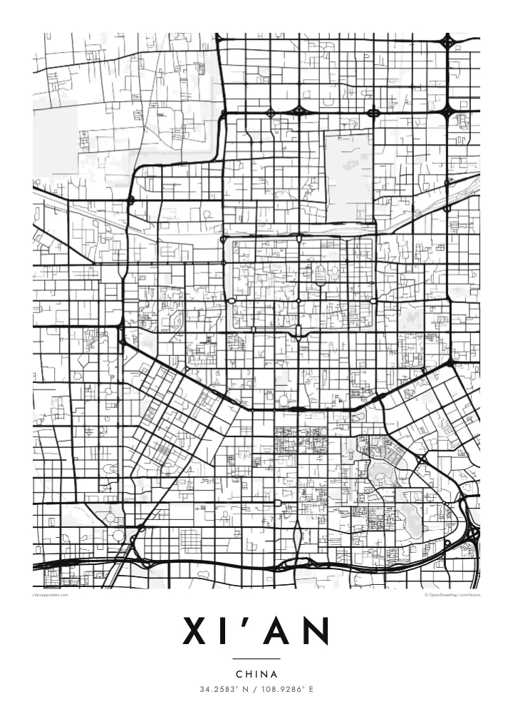
A continuous rectangle of wall and moat encloses the old town. It is one of the most complete ancient city walls in China and gives the poster a ready-made frame.
Minimalist map poster · China
A rectangular walled city with four straight avenues meeting at the Bell Tower, set on a wide river plain
34.2583° N / 108.9286° E


One city, five moods
Tap a style to see it on the wall. Every style is included in the same $9 price.
 Actual pixels · 24 × 36″ HD file
Print-sharp
This is a crop of the real HD file at 100%. The paid download is rendered on our servers at 300 DPI, up to 7,200 × 10,800 pixels, so even the smallest lanes stay crisp on a 24 × 36″ print.
The map
Xi’an has one of the clearest plans of any large city. At its heart is a rectangle defined by the Ming dynasty city wall, about 13.7 kilometres long and surrounded by a moat. Four main streets run from the Bell Tower at the centre to the four gates in the wall, dividing the old town into quarters. Outside, newer districts extend the same orthogonal logic in every direction.
That grid reflects a much older layout. Tang dynasty Chang’an, which covered much of the present city, was laid out as a strict chessboard of walled wards and avenues. South of the walls, the Big Wild Goose Pagoda stands at the end of a long straight road, while the Wei River flows to the north and the ridges of the Qinling Mountains line the southern horizon.
Xi’an served as the capital of many Chinese dynasties and was the eastern starting point of the Silk Road. The Terracotta Army, discovered in 1974, lies east of the city in Lintong, near the mausoleum of the first Qin emperor. A Xi’an map poster frames the walled core that still orients the city today.
A continuous rectangle of wall and moat encloses the old town. It is one of the most complete ancient city walls in China and gives the poster a ready-made frame.
East, West, North and South Streets meet at the Bell Tower near the middle of the walled city, forming a cross that divides the old town into four quarters.
South of the walls, the Tang dynasty pagoda sits inside a temple complex with long plazas and parks, marking the end of a straight avenue that leads south from the old city.
Make it yours
Add a date, a name or a line of your own, switch style, size or orientation.
Free preview is low-resolution with a watermark. The HD version is 7,200 × 10,800 px, 300 DPI, no watermark.
Why Xi’an
Xi’an appeals to travellers who walked or cycled the wall, students of Chinese history and anyone who likes a city with a clear, almost diagrammatic plan. The walled rectangle gives the poster a strong focal point without needing any explanation.
Personalise the title and subtitle with a name, a trip or a date, and edit the coordinates line to mark a spot inside the walls. Choose from Classic black & white, Noir, Paper, Blueprint and Sand, as HD files in six print sizes or a printed poster.
Get the Xi’an poster — $9| Print size | Resolution | Files |
|---|---|---|
| 30 × 40 cm | 3,543 × 4,724 px | PNG · PDF |
| 50 × 70 cm | 5,906 × 8,268 px | PNG · PDF |
| A3 · 29.7 × 42 cm | 3,508 × 4,961 px | PNG · PDF |
| A2 · 42 × 59.4 cm | 4,961 × 7,016 px | PNG · PDF |
| 18 × 24" | 5,400 × 7,200 px | PNG · PDF |
| 24 × 36" | 7,200 × 10,800 px | PNG · PDF |
For comparison, the free preview is 900 px wide, watermarked and meant for screens. The HD files have up to 8× the resolution in each direction and print cleanly at full poster size.
Yes. Drag and zoom the map in the editor — centre it on your neighbourhood, the old town or the whole metro area. The text updates independently.
The HD purchase includes 30×40 cm, 50×70 cm, A3, A2, 18×24″ and 24×36″, each as a 300 DPI PNG and a print-ready PDF.
You can download a free 900 px preview with a watermark. The paid HD files have no watermark and are sharp enough for large prints.
Send the PDF to any local print shop or online printing service and ask for the matching paper size. Matte paper and a thin black or oak frame suit this style best.
Nearby
