The Pentagon
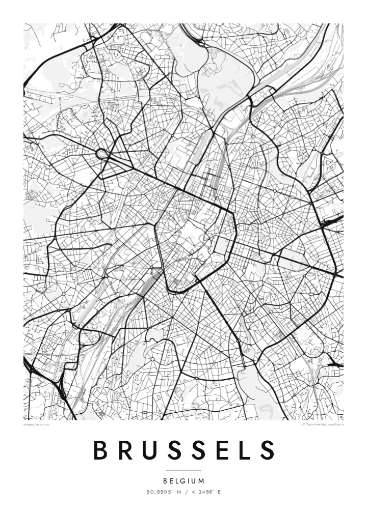
The inner ring road traces a five-sided outline around the old centre. It is the clearest shape on any Brussels print and anchors the whole composition.
Minimalist map poster · Belgium
A pentagon of boulevards around the old centre, a canal along its western side and forest to the south-east.
50.8505° N / 4.3488° E


One city, five moods
Tap a style to see it on the wall. Every style is included in the same $9 price.
 Actual pixels · 24 × 36″ HD file
Print-sharp
This is a crop of the real HD file at 100%. The paid download is rendered on our servers at 300 DPI, up to 7,200 × 10,800 pixels, so even the smallest lanes stay crisp on a 24 × 36″ print.
The map
The centre of Brussels is enclosed by a ring of wide boulevards laid out along the line of its fourteenth-century walls. Because the walls formed an irregular five-sided shape, locals simply call the historic core the Pentagon. Inside it, medieval streets converge on the Grand-Place, a UNESCO World Heritage square framed by guildhalls and the Town Hall.
The River Senne, which once ran through the centre, was covered over in the nineteenth century. On today's map, water appears mainly as the canal along the western edge of the Pentagon, part of the route between Charleroi and Antwerp. To the east, the European Quarter adds large institutional blocks and Leopold Park, and the Sonian Forest spreads beyond the southern suburbs.
Further north, near Heysel, the Atomium built for the 1958 World's Fair stands in a park beside the exhibition grounds. A Brussels map poster puts all of this in one frame: the unmistakable pentagon at the centre, the canal, the avenues radiating outward and the green spaces around the city.
The inner ring road traces a five-sided outline around the old centre. It is the clearest shape on any Brussels print and anchors the whole composition.
The canal runs along the western side of the centre from south-west to north, a single straight line of water on an otherwise landlocked map.
A large beech forest reaches into the south-eastern edge of the region. It appears as a broad expanse of open space crossed by a few long roads.
Make it yours
Add a date, a name or a line of your own, switch style, size or orientation.
Free preview is low-resolution with a watermark. The HD version is 7,200 × 10,800 px, 300 DPI, no watermark.
Why Brussels
Brussels is home to people from all over Europe and beyond, and many leave after a few years of work or study. A map of the city marks that chapter simply, with a central shape that everyone who lived here recognises.
Choose Brussels, Bruxelles or Brussel for the title, add a subtitle and the coordinates line, and pick Classic black & white, Noir, Paper, Blueprint or Sand. The HD files cost $9, and printed posters ship from partners in 30+ countries.
Get the Brussels poster — $9| Print size | Resolution | Files |
|---|---|---|
| 30 × 40 cm | 3,543 × 4,724 px | PNG · PDF |
| 50 × 70 cm | 5,906 × 8,268 px | PNG · PDF |
| A3 · 29.7 × 42 cm | 3,508 × 4,961 px | PNG · PDF |
| A2 · 42 × 59.4 cm | 4,961 × 7,016 px | PNG · PDF |
| 18 × 24" | 5,400 × 7,200 px | PNG · PDF |
| 24 × 36" | 7,200 × 10,800 px | PNG · PDF |
For comparison, the free preview is 900 px wide, watermarked and meant for screens. The HD files have up to 8× the resolution in each direction and print cleanly at full poster size.
Yes. Drag and zoom the map in the editor — centre it on your neighbourhood, the old town or the whole metro area. The text updates independently.
The HD purchase includes 30×40 cm, 50×70 cm, A3, A2, 18×24″ and 24×36″, each as a 300 DPI PNG and a print-ready PDF.
You can download a free 900 px preview with a watermark. The paid HD files have no watermark and are sharp enough for large prints.
Send the PDF to any local print shop or online printing service and ask for the matching paper size. Matte paper and a thin black or oak frame suit this style best.
Nearby
