Yuzhong peninsula
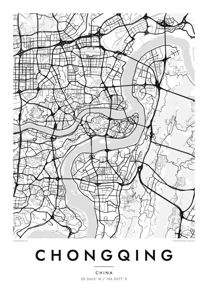
The old centre fills a slender finger of land between the Jialing and Yangtze, ending at Chaotianmen, where the two rivers meet and continue east as one.
Minimalist map poster · China
A mountain city folded around the meeting of two rivers, its streets climbing hillsides and bridges stitching every bank together
29.5603° N / 106.5577° E


One city, five moods
Tap a style to see it on the wall. Every style is included in the same $9 price.
 Actual pixels · 24 × 36″ HD file
Print-sharp
This is a crop of the real HD file at 100%. The paid download is rendered on our servers at 300 DPI, up to 7,200 × 10,800 pixels, so even the smallest lanes stay crisp on a 24 × 36″ print.
The map
Chongqing is built where the Jialing River flows into the Yangtze, and the map makes that meeting point unmistakable. The historic core of Yuzhong occupies a narrow, rocky peninsula between the two rivers, tapering to a point at Chaotianmen, where the waters join. From there the city spreads across both banks and up into the surrounding ridges, filling valleys and hilltops alike.
Few large cities are this uneven. Streets here do not follow a grid; they curve along contour lines, switch back up slopes and stop abruptly at cliffs, so the pattern on paper looks more like a set of branching veins than a planned plan. Roads sit at different levels, and a building's ground floor on one side may be several storeys up on the other.
A Chongqing map poster turns this terrain into an intricate drawing. Its many bridges, which have earned it the nickname of China's bridge city, cross the Yangtze and Jialing again and again, linking districts that the rivers and hills would otherwise keep apart. The result is one of the most distinctive urban outlines in the world.
The old centre fills a slender finger of land between the Jialing and Yangtze, ending at Chaotianmen, where the two rivers meet and continue east as one.
Roads wind around hills rather than cutting through them, so neighbourhoods appear as curling clusters of streets separated by steep slopes and gaps where the ground falls away.
Dozens of bridges span the two rivers, and on the map they appear as a series of straight lines stitching the curving banks together at regular intervals.
Make it yours
Add a date, a name or a line of your own, switch style, size or orientation.
Free preview is low-resolution with a watermark. The HD version is 7,200 × 10,800 px, 300 DPI, no watermark.
Why Chongqing
For anyone who has climbed Chongqing's stairways, ridden the monorail through its hills or looked out over the rivers at night, this map is an unmistakable reminder of the city. It works as a piece for a home there, a keepsake from a trip or a gift for someone who grew up among its slopes.
Add a title and a date that matter to you, and choose from five styles: Classic black & white, Noir, Paper, Blueprint or Sand. The layered streets and river curves read clearly in every version, from dark Noir to warm, soft Sand.
Get the Chongqing poster — $9| Print size | Resolution | Files |
|---|---|---|
| 30 × 40 cm | 3,543 × 4,724 px | PNG · PDF |
| 50 × 70 cm | 5,906 × 8,268 px | PNG · PDF |
| A3 · 29.7 × 42 cm | 3,508 × 4,961 px | PNG · PDF |
| A2 · 42 × 59.4 cm | 4,961 × 7,016 px | PNG · PDF |
| 18 × 24" | 5,400 × 7,200 px | PNG · PDF |
| 24 × 36" | 7,200 × 10,800 px | PNG · PDF |
For comparison, the free preview is 900 px wide, watermarked and meant for screens. The HD files have up to 8× the resolution in each direction and print cleanly at full poster size.
Yes. Drag and zoom the map in the editor — centre it on your neighbourhood, the old town or the whole metro area. The text updates independently.
The HD purchase includes 30×40 cm, 50×70 cm, A3, A2, 18×24″ and 24×36″, each as a 300 DPI PNG and a print-ready PDF.
You can download a free 900 px preview with a watermark. The paid HD files have no watermark and are sharp enough for large prints.
Send the PDF to any local print shop or online printing service and ask for the matching paper size. Matte paper and a thin black or oak frame suit this style best.
Nearby
