The beach
The long, straight Atlantic shore runs the full length of the map. Its hard-packed sand made the city famous for driving and racing.
Minimalist map poster · United States
29.2108° N / 81.0228° W
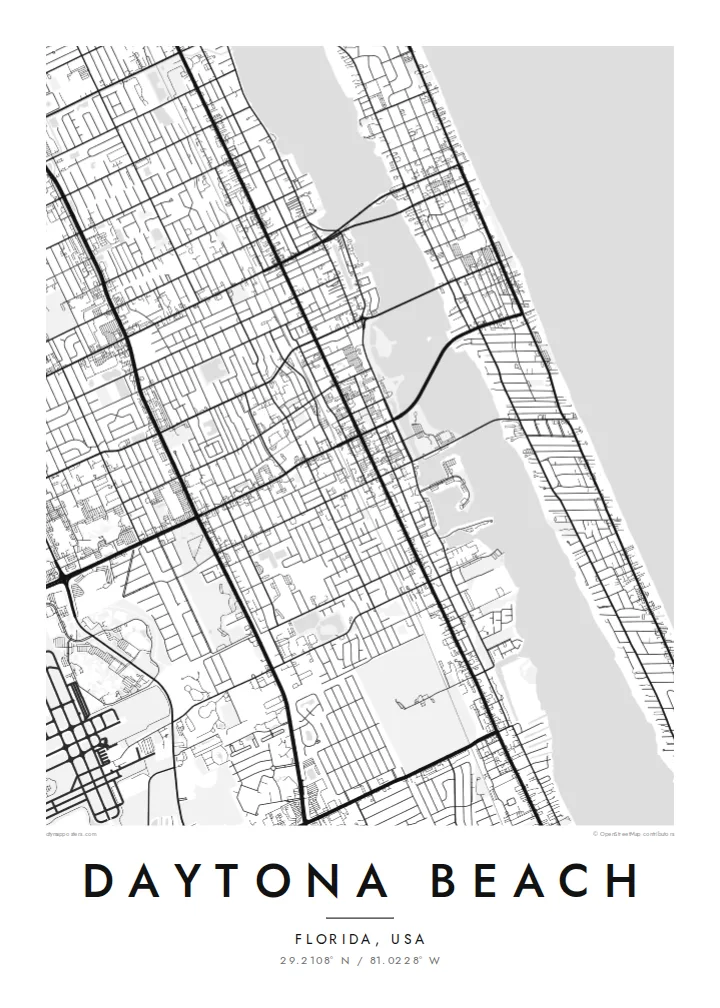
A long barrier-island beach and a mainland grid, divided by the Halifax River and joined by a series of bridges.


One city, five moods
Tap a style to see it on the wall. Every style costs the same — printed, framed or as HD files.
 Actual pixels · 24 × 36″ print file
Print-sharp
This is a 100% crop of the real print file. Every poster — printed, framed or downloaded — is rendered on our servers at 300 DPI, up to 7,200 × 10,800 pixels, so even the smallest lanes stay crisp on a 24 × 36″ print.
On the wall


The map
Daytona Beach stretches along Florida's Atlantic coast in two parallel strips. On the east side is a long, narrow barrier island facing the ocean, lined with hotels and houses. On the west side is the mainland, with a downtown and residential grid. Between them runs the Halifax River, part of the Intracoastal Waterway, and several bridges cross it.
From above, the coastline is almost a straight line. The beach runs for miles along the edge of the map, and a pier juts out into the Atlantic. Inland, the streets form an orderly grid that becomes more spread out toward the west, where the large oval of Daytona International Speedway and the airport take up large, distinctive areas.
Daytona Beach is famous for its firm, flat sand, where early motorists set land speed records in the early twentieth century and where cars can still drive on parts of the beach. NASCAR was founded here in 1948, and the Daytona 500 is held each year at the Speedway. A Daytona Beach map poster combines the ocean, the river and the racetrack in one image.
The long, straight Atlantic shore runs the full length of the map. Its hard-packed sand made the city famous for driving and racing.
The river, part of the Intracoastal Waterway, separates the barrier island from the mainland. Several bridges cross it.
Daytona International Speedway is a large, bold shape on the western side of the city. It is one of the most recognisable features on any Florida map.
Make it yours
Add a date, a name or a line of your own, switch style, size or orientation.
The free preview is low-resolution with a watermark. Prints and HD files are rendered at 300 DPI, up to 7,200 × 10,800 px, without a watermark.
Why Daytona Beach
This map suits a racing fan, someone who spent spring breaks or family holidays by the ocean, or a local who knows every bridge. The coastline and Speedway make a striking image.
You can personalise the title, subtitle and coordinates line with a race date, a name or a special memory. Then choose Classic black & white, Noir, Paper, Blueprint or Sand.
Order the Daytona Beach poster| Print size | Resolution | Files |
|---|---|---|
| 30 × 40 cm11.8 × 15.7″ | 3,543 × 4,724 px | PNG · PDF |
| 29.7 × 42 cm (A3)11.7 × 16.5″ | 3,508 × 4,961 px | PNG · PDF |
| 42 × 59.4 cm (A2)16.5 × 23.4″ | 4,961 × 7,016 px | PNG · PDF |
| 45.7 × 61 cm18 × 24″ | 5,400 × 7,200 px | PNG · PDF |
| 50 × 70 cm19.7 × 27.6″ | 5,906 × 8,268 px | PNG · PDF |
| 61 × 91.4 cm24 × 36″ | 7,200 × 10,800 px | PNG · PDF |
For comparison, the free preview is 900 px wide, watermarked and meant for screens. The HD files have up to 8× the resolution in each direction and print cleanly at full poster size.
Pick a style at the top of the page, then choose Printed Poster — a size and, if you like, a frame — or Digital HD Files. Checkout takes one step, and your order page updates as soon as the payment goes through.
It is printed on premium 200 gsm matte paper in one of six sizes, from 30 × 40 cm to 24 × 36″. Printed posters start at $39, shipping included.
Yes. Choose a solid wood frame in black, white, natural oak or dark wood. It comes with shatterproof glazing and is ready to hang. Framed posters start at $99, shipping included.
Shipping is free to 60+ countries. Each poster is printed by the nearest of our print partners in 30+ countries and usually arrives in 3–7 business days. You can follow the status and tracking under My Orders. A few countries take 2–5 weeks, and where we don't ship yet, the site tells you before you pay.
Send us a photo within 14 days of delivery and we will reprint it for free or refund you.
Yes. In the editor on this page, change the title, the subtitle and the coordinates line to anything you like, and pick a style and size. Printed, framed and digital orders all use exactly your design.
For $9 you get 300 DPI PNG and print-ready PDF files in all six sizes, without a watermark, to print anywhere. Not sure yet? Download a free watermarked preview first.
Nearby
