Durgapur Barrage
A long straight line across the Damodar, with the wide river on one side and the start of the irrigation canals on the other. It is one of the most graphic shapes on the map.
Minimalist map poster · India
23.5158° N / 87.3080° E
A planned steel town laid out in sectors between the Damodar River and the long rail and highway corridor to Kolkata
One city, five moods
Tap a style to see it on the wall. Every style costs the same — printed, framed or as HD files.
 Actual pixels · 24 × 36″ print file
Print-sharp
This is a 100% crop of the real print file. Every poster — printed, framed or downloaded — is rendered on our servers at 300 DPI, up to 7,200 × 10,800 pixels, so even the smallest lanes stay crisp on a 24 × 36″ print.
On the wall


The map
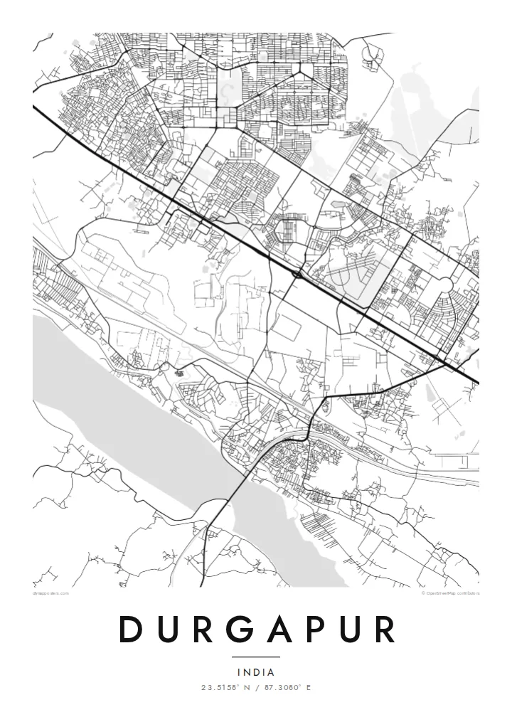
Durgapur is a planned city, and it shows from above. It was built after independence around a large state steel plant, and residential sectors sit in separate blocks divided by broad roads and green buffers. The result is a map that looks organised rather than grown, with industrial land, townships and open ground each clearly separated from the others.
The Damodar River forms the southern edge. The Durgapur Barrage, completed in the 1950s, stretches across its wide sandy bed and feeds irrigation canals that run across the plain. North of the river, the national highway and the railway to Kolkata run side by side through the city, and most of the urban area lines up along this single east–west band.
A Durgapur map poster brings all these layers onto one sheet: the geometric sectors, the plant with its rail sidings, the canals and the pale width of the river. Durgapur is also home to a National Institute of Technology, whose campus shows up as its own neat block. In black and white, the city looks like the engineering drawing it once started as.
A long straight line across the Damodar, with the wide river on one side and the start of the irrigation canals on the other. It is one of the most graphic shapes on the map.
Residential areas were planned as separate units with their own internal street loops. Seen from above, they read as a series of distinct, self-contained patterns set apart by main roads.
The highway and the railway run in parallel across the city from west to east, a strong double line that ties the plant, the townships and the station together.
Make it yours
Add a date, a name or a line of your own, switch style, size or orientation.
The free preview is low-resolution with a watermark. Prints and HD files are rendered at 300 DPI, up to 7,200 × 10,800 px, without a watermark.
Why Durgapur
Many people here have a family connection to the plant, the college or one of the townships, and a map of Durgapur records that planned landscape in a way a photograph cannot. It suits a study, an office wall or a gift for someone who has moved away.
You can change the title and subtitle, for example to name a sector or add a year, and adjust the coordinates line. Choose from five styles: Classic black & white, Noir, Paper, Blueprint or Sand. Blueprint suits a city that began as a plan.
Order the Durgapur poster| Print size | Resolution | Files |
|---|---|---|
| 30 × 40 cm11.8 × 15.7″ | 3,543 × 4,724 px | PNG · PDF |
| 29.7 × 42 cm (A3)11.7 × 16.5″ | 3,508 × 4,961 px | PNG · PDF |
| 42 × 59.4 cm (A2)16.5 × 23.4″ | 4,961 × 7,016 px | PNG · PDF |
| 45.7 × 61 cm18 × 24″ | 5,400 × 7,200 px | PNG · PDF |
| 50 × 70 cm19.7 × 27.6″ | 5,906 × 8,268 px | PNG · PDF |
| 61 × 91.4 cm24 × 36″ | 7,200 × 10,800 px | PNG · PDF |
For comparison, the free preview is 900 px wide, watermarked and meant for screens. The HD files have up to 8× the resolution in each direction and print cleanly at full poster size.
Pick a style at the top of the page, then choose Printed Poster — a size and, if you like, a frame — or Digital HD Files. Checkout takes one step, and your order page updates as soon as the payment goes through.
It is printed on premium 200 gsm matte paper in one of six sizes, from 30 × 40 cm to 24 × 36″. Printed posters start at $39, shipping included.
Yes. Choose a solid wood frame in black, white, natural oak or dark wood. It comes with shatterproof glazing and is ready to hang. Framed posters start at $99, shipping included.
Shipping is free to 60+ countries. Each poster is printed by the nearest of our print partners in 30+ countries and usually arrives in 3–7 business days. You can follow the status and tracking under My Orders. A few countries take 2–5 weeks, and where we don't ship yet, the site tells you before you pay.
Send us a photo within 14 days of delivery and we will reprint it for free or refund you.
Yes. In the editor on this page, change the title, the subtitle and the coordinates line to anything you like, and pick a style and size. Printed, framed and digital orders all use exactly your design.
For $9 you get 300 DPI PNG and print-ready PDF files in all six sizes, without a watermark, to print anywhere. Not sure yet? Download a free watermarked preview first.
Nearby
