The Bosphorus
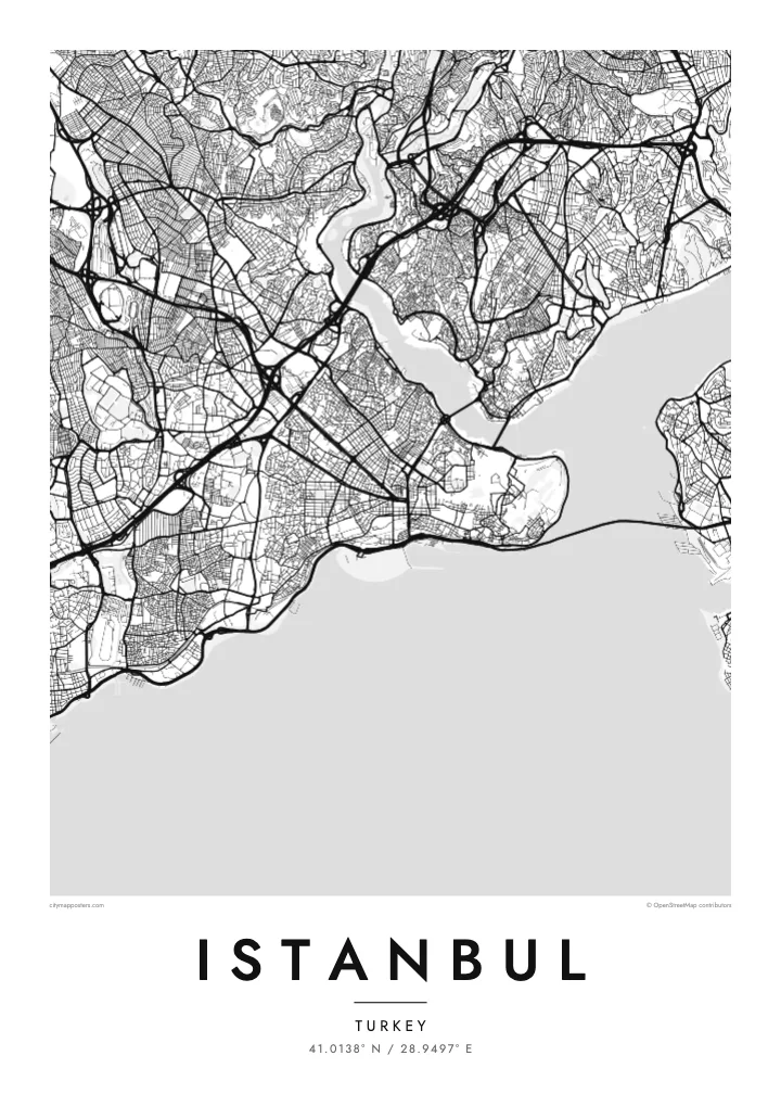
A winding strait about 30 kilometres long separating the European and Asian shores. On the map it forms a clean dividing line, crossed by three suspension bridges between the Marmara and the Black Sea.
Minimalist map poster · Turkey
41.0138° N / 28.9497° E
A city split by the Bosphorus, with the Golden Horn curving inland and the Sea of Marmara closing the south
One city, five moods
Tap a style to see it on the wall. Every style costs the same — printed, framed or as HD files.
 Actual pixels · 24 × 36″ print file
Print-sharp
This is a 100% crop of the real print file. Every poster — printed, framed or downloaded — is rendered on our servers at 300 DPI, up to 7,200 × 10,800 pixels, so even the smallest lanes stay crisp on a 24 × 36″ print.
On the wall


The map
Istanbul is defined by three bodies of water. The Bosphorus strait runs north to south between Europe and Asia, the Golden Horn cuts a long curved inlet into the European side, and the Sea of Marmara lines the southern shore. Between them, the land breaks into distinct pieces, each with its own street pattern, and the city reads as a group of shores facing one another.
The historic peninsula, bounded by the Golden Horn and the Marmara, still carries the line of the Theodosian Walls along its landward side and a tangle of old streets around Hagia Sophia and the Grand Bazaar. Across the Galata Bridge, Beyoğlu climbs its hill. The Asian shore, with Üsküdar and Kadıköy, spreads more loosely, and suspension bridges span the Bosphorus further north.
As Byzantium, then Constantinople, the city served as a capital of the Roman, Byzantine and Ottoman empires for more than fifteen centuries. Its historic areas were inscribed as a UNESCO World Heritage Site in 1985. An Istanbul map poster makes the geography behind that history easy to see: a narrow strait, a sheltered harbour and a peninsula that was simple to defend.
A winding strait about 30 kilometres long separating the European and Asian shores. On the map it forms a clean dividing line, crossed by three suspension bridges between the Marmara and the Black Sea.
This horn-shaped inlet curves north-west from the Bosphorus, separating the historic peninsula from Galata and Beyoğlu. Its outline is one of the most recognisable shapes on any map of the city.
The fifth-century land walls run from the Golden Horn to the Sea of Marmara, marking the western edge of the old city as a long, slightly curving line.
Make it yours
Add a date, a name or a line of your own, switch style, size or orientation.
The free preview is low-resolution with a watermark. Prints and HD files are rendered at 300 DPI, up to 7,200 × 10,800 px, without a watermark.
Why Istanbul
Istanbul is a map for people who have crossed between its shores by ferry, lived on one side and worked on the other, or simply remember the view from a hill above the water. The coastlines alone make a composition that needs no explanation.
Set the title as Istanbul or a single neighbourhood, add a subtitle with a date or a name, and choose how the coordinates appear. The poster comes in Classic black & white, Noir, Paper, Blueprint and Sand, as instant HD files or printed and shipped.
Order the Istanbul poster| Print size | Resolution | Files |
|---|---|---|
| 30 × 40 cm11.8 × 15.7″ | 3,543 × 4,724 px | PNG · PDF |
| 29.7 × 42 cm (A3)11.7 × 16.5″ | 3,508 × 4,961 px | PNG · PDF |
| 42 × 59.4 cm (A2)16.5 × 23.4″ | 4,961 × 7,016 px | PNG · PDF |
| 45.7 × 61 cm18 × 24″ | 5,400 × 7,200 px | PNG · PDF |
| 50 × 70 cm19.7 × 27.6″ | 5,906 × 8,268 px | PNG · PDF |
| 61 × 91.4 cm24 × 36″ | 7,200 × 10,800 px | PNG · PDF |
For comparison, the free preview is 900 px wide, watermarked and meant for screens. The HD files have up to 8× the resolution in each direction and print cleanly at full poster size.
Pick a style at the top of the page, then choose Printed Poster — a size and, if you like, a frame — or Digital HD Files. Checkout takes one step, and your order page updates as soon as the payment goes through.
It is printed on premium 200 gsm matte paper in one of six sizes, from 30 × 40 cm to 24 × 36″. Printed posters start at $39, shipping included.
Yes. Choose a solid wood frame in black, white, natural oak or dark wood. It comes with shatterproof glazing and is ready to hang. Framed posters start at $99, shipping included.
Shipping is free to 60+ countries. Each poster is printed by the nearest of our print partners in 30+ countries and usually arrives in 3–7 business days. You can follow the status and tracking under My Orders. A few countries take 2–5 weeks, and where we don't ship yet, the site tells you before you pay.
Send us a photo within 14 days of delivery and we will reprint it for free or refund you.
Yes. In the editor on this page, change the title, the subtitle and the coordinates line to anything you like, and pick a style and size. Printed, framed and digital orders all use exactly your design.
For $9 you get 300 DPI PNG and print-ready PDF files in all six sizes, without a watermark, to print anywhere. Not sure yet? Download a free watermarked preview first.
Nearby
