Landwehr Canal
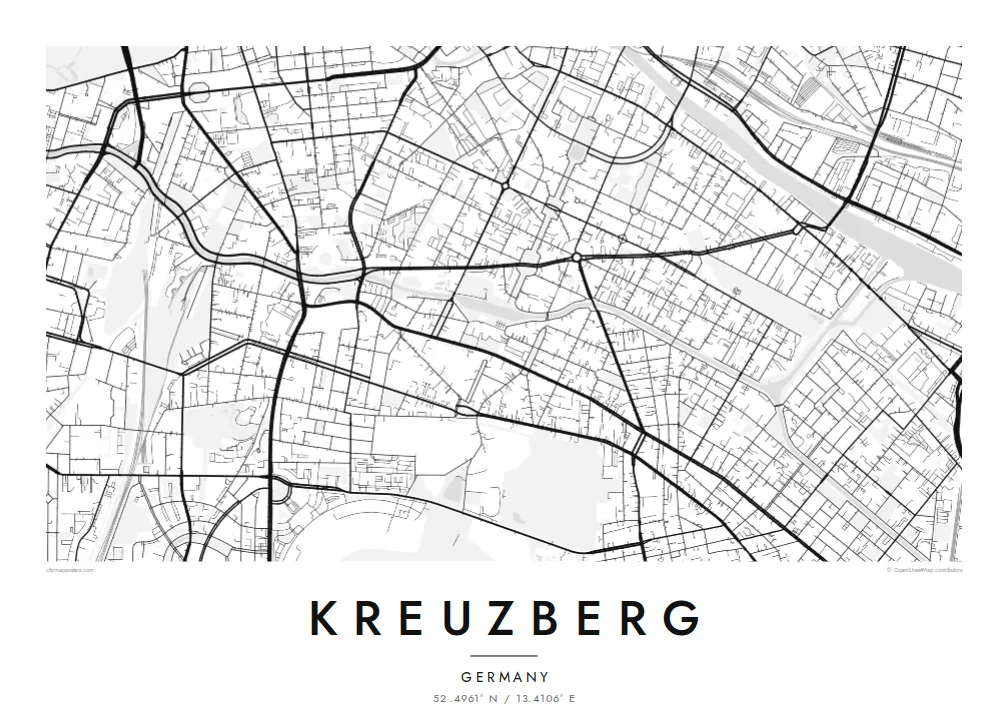
The canal curves through the district with streets on both banks. It is the clearest single line on the poster and ties the neighbourhoods on either side together.
Minimalist map poster · Germany
52.4961° N / 13.4106° E
A canal curving through old tenement blocks, the Spree to the north-east and a hill in the south-west


One city, five moods
Tap a style to see it on the wall. Every style costs the same — printed, framed or as HD files.
 Actual pixels · 24 × 36″ print file
Print-sharp
This is a 100% crop of the real print file. Every poster — printed, framed or downloaded — is rendered on our servers at 300 DPI, up to 7,200 × 10,800 pixels, so even the smallest lanes stay crisp on a 24 × 36″ print.
On the wall


The district
Kreuzberg is a Berlin district whose map is shaped by water and one small hill. The Landwehr Canal runs through it from east to west in a long curve, lined by trees and embankment streets, while the Spree forms its north-eastern edge. In the south-west, Viktoriapark rises around the Kreuzberg itself, the hill topped by a nineteenth-century iron monument that gave the district its name.
Between them lies a dense pattern of nineteenth-century blocks with deep courtyards. Oranienstraße, Bergmannstraße and the streets around Kottbusser Tor each form their own neighbourhoods. Görlitzer Park occupies the site of a former railway station, and the Berlin Wall once ran along parts of the district's northern boundary.
A Kreuzberg map poster makes the Landwehr Canal the central line of the composition. Its gentle curve cuts across a regular fabric of city blocks, while the green mass of Viktoriapark and the long strip of Görlitzer Park break the pattern at either end.
The canal curves through the district with streets on both banks. It is the clearest single line on the poster and ties the neighbourhoods on either side together.
The hill in the south-west, crowned by the monument after which Kreuzberg is named, appears as a wooded patch with winding paths among straight streets.
Built on the grounds of an old railway station, the park forms a long open shape in the east, its outline still following the former rail land.
Make it yours
Add a date, a name or a line of your own, switch style, size or orientation.
The free preview is low-resolution with a watermark. Prints and HD files are rendered at 300 DPI, up to 7,200 × 10,800 px, without a watermark.
Why Kreuzberg
Kreuzberg is a district people move to, live in intensely and remember for a long time. A map of it holds the canal walks, the courtyards and the late nights in one frame, which is why it often hangs in first flats elsewhere.
Personalise the title, subtitle and coordinates line to name your Kiez or the years you spent there. Noir and Classic black and white suit the district's graphic block pattern, while Blueprint emphasises the canal.
Order the Kreuzberg poster| Print size | Resolution | Files |
|---|---|---|
| 30 × 40 cm11.8 × 15.7″ | 3,543 × 4,724 px | PNG · PDF |
| 29.7 × 42 cm (A3)11.7 × 16.5″ | 3,508 × 4,961 px | PNG · PDF |
| 42 × 59.4 cm (A2)16.5 × 23.4″ | 4,961 × 7,016 px | PNG · PDF |
| 45.7 × 61 cm18 × 24″ | 5,400 × 7,200 px | PNG · PDF |
| 50 × 70 cm19.7 × 27.6″ | 5,906 × 8,268 px | PNG · PDF |
| 61 × 91.4 cm24 × 36″ | 7,200 × 10,800 px | PNG · PDF |
For comparison, the free preview is 900 px wide, watermarked and meant for screens. The HD files have up to 8× the resolution in each direction and print cleanly at full poster size.
Pick a style at the top of the page, then choose Printed Poster — a size and, if you like, a frame — or Digital HD Files. Checkout takes one step, and your order page updates as soon as the payment goes through.
It is printed on premium 200 gsm matte paper in one of six sizes, from 30 × 40 cm to 24 × 36″. Printed posters start at $39, shipping included.
Yes. Choose a solid wood frame in black, white, natural oak or dark wood. It comes with shatterproof glazing and is ready to hang. Framed posters start at $99, shipping included.
Shipping is free to 60+ countries. Each poster is printed by the nearest of our print partners in 30+ countries and usually arrives in 3–7 business days. You can follow the status and tracking under My Orders. A few countries take 2–5 weeks, and where we don't ship yet, the site tells you before you pay.
Send us a photo within 14 days of delivery and we will reprint it for free or refund you.
Yes. In the editor on this page, change the title, the subtitle and the coordinates line to anything you like, and pick a style and size. Printed, framed and digital orders all use exactly your design.
For $9 you get 300 DPI PNG and print-ready PDF files in all six sizes, without a watermark, to print anywhere. Not sure yet? Download a free watermarked preview first.
Nearby
