Crossing diagonals
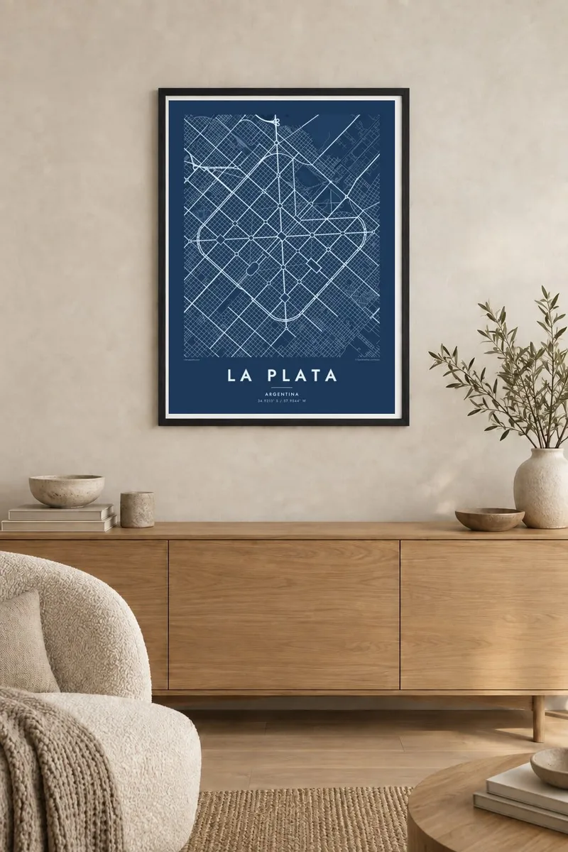
Two great diagonals cut the square grid from corner to corner, with more diagonals radiating from the centre, forming the defining pattern of the city.
Minimalist map poster · Argentina
34.9213° S / 57.9544° W
A planned capital drawn as a perfect square grid, cut by diagonals and punctuated by a plaza every six blocks

One city, five moods
Tap a style to see it on the wall. Every style costs the same — printed, framed or as HD files.
 Actual pixels · 24 × 36″ print file
Print-sharp
This is a 100% crop of the real print file. Every poster — printed, framed or downloaded — is rendered on our servers at 300 DPI, up to 7,200 × 10,800 pixels, so even the smallest lanes stay crisp on a 24 × 36″ print.
On the wall


The map
La Plata, the capital of Buenos Aires Province, is one of the most distinctive planned cities in the world. Founded in 1882, it was designed as a square grid of streets enclosed by a ring boulevard, with two main diagonals crossing from corner to corner and further diagonals radiating from the centre. At regular intervals the grid opens into squares and parks, so a plaza appears roughly every six blocks.
A monumental axis runs through the middle of the city, linking the cathedral, government buildings and the central square. At one end lies the Paseo del Bosque, a large park that holds the Museum of Natural History, the zoo and the university observatory. Streets are numbered rather than named, reinforcing the logic of the plan.
A La Plata map poster shows this geometry with complete clarity: the square outline, the crossing diagonals, the rhythm of plazas and the green mass of the Bosque. Few cities look so deliberate from above, and in black and white the plan reads like an architectural drawing.
Two great diagonals cut the square grid from corner to corner, with more diagonals radiating from the centre, forming the defining pattern of the city.
The grid opens into squares and parks at regular intervals, creating a steady rhythm of open spaces across the entire poster.
The large park at the edge of the grid, home to the Museum of Natural History and the observatory, appears as a broad green area against the dense streets.
Make it yours
Add a date, a name or a line of your own, switch style, size or orientation.
The free preview is low-resolution with a watermark. Prints and HD files are rendered at 300 DPI, up to 7,200 × 10,800 px, without a watermark.
Why La Plata
La Plata is loved by students, residents and anyone who appreciates urban design. Its map is recognisable even to people who have never visited, which makes it a strong piece for a study, a studio or a university office.
Add your own title, subtitle and coordinates line, perhaps a graduation year or a street number, and choose from five styles, including Blueprint. Download the files for $9 or order a matte print with an optional wooden frame.
Order the La Plata poster| Print size | Resolution | Files |
|---|---|---|
| 30 × 40 cm11.8 × 15.7″ | 3,543 × 4,724 px | PNG · PDF |
| 29.7 × 42 cm (A3)11.7 × 16.5″ | 3,508 × 4,961 px | PNG · PDF |
| 42 × 59.4 cm (A2)16.5 × 23.4″ | 4,961 × 7,016 px | PNG · PDF |
| 45.7 × 61 cm18 × 24″ | 5,400 × 7,200 px | PNG · PDF |
| 50 × 70 cm19.7 × 27.6″ | 5,906 × 8,268 px | PNG · PDF |
| 61 × 91.4 cm24 × 36″ | 7,200 × 10,800 px | PNG · PDF |
For comparison, the free preview is 900 px wide, watermarked and meant for screens. The HD files have up to 8× the resolution in each direction and print cleanly at full poster size.
Pick a style at the top of the page, then choose Printed Poster — a size and, if you like, a frame — or Digital HD Files. Checkout takes one step, and your order page updates as soon as the payment goes through.
It is printed on premium 200 gsm matte paper in one of six sizes, from 30 × 40 cm to 24 × 36″. Printed posters start at $39, shipping included.
Yes. Choose a solid wood frame in black, white, natural oak or dark wood. It comes with shatterproof glazing and is ready to hang. Framed posters start at $99, shipping included.
Shipping is free to 60+ countries. Each poster is printed by the nearest of our print partners in 30+ countries and usually arrives in 3–7 business days. You can follow the status and tracking under My Orders. A few countries take 2–5 weeks, and where we don't ship yet, the site tells you before you pay.
Send us a photo within 14 days of delivery and we will reprint it for free or refund you.
Yes. In the editor on this page, change the title, the subtitle and the coordinates line to anything you like, and pick a style and size. Printed, framed and digital orders all use exactly your design.
For $9 you get 300 DPI PNG and print-ready PDF files in all six sizes, without a watermark, to print anywhere. Not sure yet? Download a free watermarked preview first.
Nearby
