Palace and old town
Below the palace ridge, the old town is a knot of narrow, irregular lanes. It is the densest part of the map and sits high up on the slope, above the modern town.
Minimalist map poster · India
34.1650° N / 77.5840° E
A high-altitude town fanning down a dry slope above the Indus, crowned by its palace and ringed by bare mountains.

One city, five moods
Tap a style to see it on the wall. Every style costs the same — printed, framed or as HD files.
 Actual pixels · 24 × 36″ print file
Print-sharp
This is a 100% crop of the real print file. Every poster — printed, framed or downloaded — is rendered on our servers at 300 DPI, up to 7,200 × 10,800 pixels, so even the smallest lanes stay crisp on a 24 × 36″ print.
On the wall
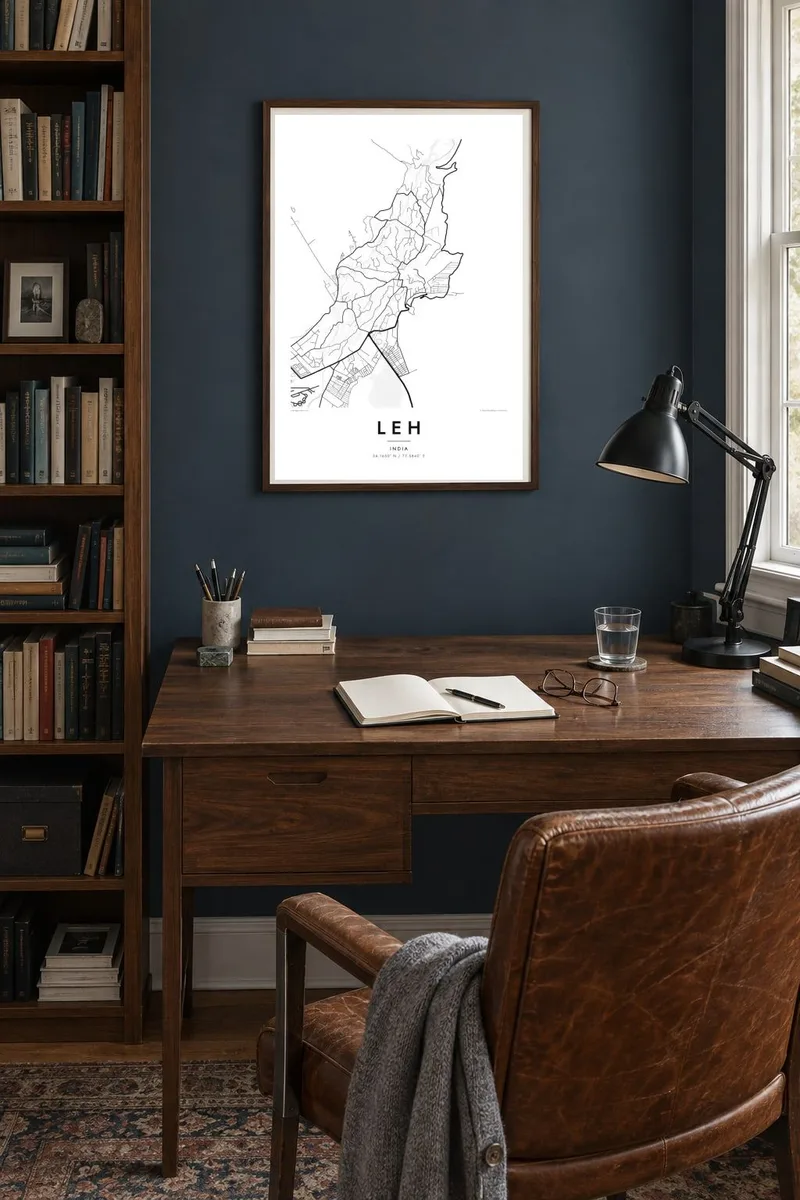


The map
Leh sits at roughly 3,500 metres in the Indus valley in Ladakh, spreading down a broad alluvial slope toward the river. From above, the town takes the shape of a fan: a compact old quarter at the top, beneath the ridge, and looser, greener streets that thin out into fields and irrigated plots on the way down to the valley floor.
The old town gathers at the foot of Leh Palace, a nine-storey royal residence built in the seventeenth century, with the Namgyal Tsemo monastery higher on the ridge behind it. Across town the white Shanti Stupa stands on its own hill. For centuries Leh was a stop on caravan routes between the Himalaya and Central Asia, which explains its layout around a central market street.
A Leh map poster turns this setting into a study of contrast. The dense lanes of the old town appear as a tight knot, while roads uncoil across empty, dry terrain toward the airport and the Indus. Much of the sheet is quiet, open ground, which suits the minimal style and gives the town itself a strong presence.
Below the palace ridge, the old town is a knot of narrow, irregular lanes. It is the densest part of the map and sits high up on the slope, above the modern town.
The river runs along the southern edge of the town, well below the centre. Fields and villages follow its course, forming a green line through otherwise dry country.
Roads leading out of Leh wind across the bare slopes in long curves and hairpins. In black and white they read almost like handwriting on an empty page.
Make it yours
Add a date, a name or a line of your own, switch style, size or orientation.
The free preview is low-resolution with a watermark. Prints and HD files are rendered at 300 DPI, up to 7,200 × 10,800 px, without a watermark.
Why Leh
Leh is a place people travel a long way to reach, and many come back with the altitude, the light and the mountain roads still on their minds. A map of the town is a restrained way to remember the journey.
Add the date of your trip or the name of a pass to the subtitle, keep or edit the coordinates line, and choose one of five styles. Sand echoes the dry valley, while Noir makes the road lines stand out against a dark ground.
Order the Leh poster| Print size | Resolution | Files |
|---|---|---|
| 30 × 40 cm11.8 × 15.7″ | 3,543 × 4,724 px | PNG · PDF |
| 29.7 × 42 cm (A3)11.7 × 16.5″ | 3,508 × 4,961 px | PNG · PDF |
| 42 × 59.4 cm (A2)16.5 × 23.4″ | 4,961 × 7,016 px | PNG · PDF |
| 45.7 × 61 cm18 × 24″ | 5,400 × 7,200 px | PNG · PDF |
| 50 × 70 cm19.7 × 27.6″ | 5,906 × 8,268 px | PNG · PDF |
| 61 × 91.4 cm24 × 36″ | 7,200 × 10,800 px | PNG · PDF |
For comparison, the free preview is 900 px wide, watermarked and meant for screens. The HD files have up to 8× the resolution in each direction and print cleanly at full poster size.
Pick a style at the top of the page, then choose Printed Poster — a size and, if you like, a frame — or Digital HD Files. Checkout takes one step, and your order page updates as soon as the payment goes through.
It is printed on premium 200 gsm matte paper in one of six sizes, from 30 × 40 cm to 24 × 36″. Printed posters start at $39, shipping included.
Yes. Choose a solid wood frame in black, white, natural oak or dark wood. It comes with shatterproof glazing and is ready to hang. Framed posters start at $99, shipping included.
Shipping is free to 60+ countries. Each poster is printed by the nearest of our print partners in 30+ countries and usually arrives in 3–7 business days. You can follow the status and tracking under My Orders. A few countries take 2–5 weeks, and where we don't ship yet, the site tells you before you pay.
Send us a photo within 14 days of delivery and we will reprint it for free or refund you.
Yes. In the editor on this page, change the title, the subtitle and the coordinates line to anything you like, and pick a style and size. Printed, framed and digital orders all use exactly your design.
For $9 you get 300 DPI PNG and print-ready PDF files in all six sizes, without a watermark, to print anywhere. Not sure yet? Download a free watermarked preview first.
Nearby
