Central square
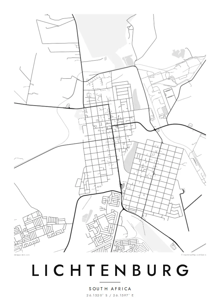
The large square at the middle of the grid is the town's defining open space, a clear rectangle around which the surrounding blocks are arranged.
Minimalist map poster · South Africa
26.1520° S / 26.1597° E
A planned grid town on the open highveld, laid out around a broad central square with farmland on every side.
One city, five moods
Tap a style to see it on the wall. Every style costs the same — printed, framed or as HD files.
 Actual pixels · 24 × 36″ print file
Print-sharp
This is a 100% crop of the real print file. Every poster — printed, framed or downloaded — is rendered on our servers at 300 DPI, up to 7,200 × 10,800 pixels, so even the smallest lanes stay crisp on a 24 × 36″ print.
On the wall


The map
Lichtenburg lies in the North West province, on the flat maize-growing highveld west of Johannesburg. Its founders laid it out as a regular grid, and that pattern is still the first thing you see on the map: straight streets crossing at right angles, long rectangular blocks, and a broad open square at the centre of it all.
In 1926 the farms around Lichtenburg became the scene of one of South Africa's largest alluvial diamond rushes, when thousands of diggers arrived to stake claims. The rush faded within years, but the town remained, supported by farming and later by cement production. Its central square honours General Koos de la Rey, a figure closely associated with Lichtenburg.
A Lichtenburg map poster is almost architectural in its clarity. The central square acts like a keystone, the grid spreads evenly around it, and beyond the last streets the roads run out straight across open farmland. It makes a clean, balanced print, one that reads well both close up and from across a room.
The large square at the middle of the grid is the town's defining open space, a clear rectangle around which the surrounding blocks are arranged.
Streets cross at right angles in long, even runs, giving the centre a disciplined, planned structure typical of South African country towns of its era.
Outside town, roads run for long distances in nearly straight lines across flat farmland, drawing a few strong strokes toward the edges of the map.
Make it yours
Add a date, a name or a line of your own, switch style, size or orientation.
The free preview is low-resolution with a watermark. Prints and HD files are rendered at 300 DPI, up to 7,200 × 10,800 px, without a watermark.
Why Lichtenburg
For families with roots in the North West, or anyone who grew up in Lichtenburg's quiet grid, this map is a direct portrait of home. Personalise the title and subtitle with a name, a date or a line of your own, and edit the coordinates line.
The grid looks especially sharp in Blueprint, and Sand echoes the colours of the highveld in winter. Download the six HD sizes for $9 as 300 DPI PNG and print-ready PDF files, or order a matte print with an optional wooden frame.
Order the Lichtenburg poster| Print size | Resolution | Files |
|---|---|---|
| 30 × 40 cm11.8 × 15.7″ | 3,543 × 4,724 px | PNG · PDF |
| 29.7 × 42 cm (A3)11.7 × 16.5″ | 3,508 × 4,961 px | PNG · PDF |
| 42 × 59.4 cm (A2)16.5 × 23.4″ | 4,961 × 7,016 px | PNG · PDF |
| 45.7 × 61 cm18 × 24″ | 5,400 × 7,200 px | PNG · PDF |
| 50 × 70 cm19.7 × 27.6″ | 5,906 × 8,268 px | PNG · PDF |
| 61 × 91.4 cm24 × 36″ | 7,200 × 10,800 px | PNG · PDF |
For comparison, the free preview is 900 px wide, watermarked and meant for screens. The HD files have up to 8× the resolution in each direction and print cleanly at full poster size.
Pick a style at the top of the page, then choose Printed Poster — a size and, if you like, a frame — or Digital HD Files. Checkout takes one step, and your order page updates as soon as the payment goes through.
It is printed on premium 200 gsm matte paper in one of six sizes, from 30 × 40 cm to 24 × 36″. Printed posters start at $39, shipping included.
Yes. Choose a solid wood frame in black, white, natural oak or dark wood. It comes with shatterproof glazing and is ready to hang. Framed posters start at $99, shipping included.
Shipping is free to 60+ countries. Each poster is printed by the nearest of our print partners in 30+ countries and usually arrives in 3–7 business days. You can follow the status and tracking under My Orders. A few countries take 2–5 weeks, and where we don't ship yet, the site tells you before you pay.
Send us a photo within 14 days of delivery and we will reprint it for free or refund you.
Yes. In the editor on this page, change the title, the subtitle and the coordinates line to anything you like, and pick a style and size. Printed, framed and digital orders all use exactly your design.
For $9 you get 300 DPI PNG and print-ready PDF files in all six sizes, without a watermark, to print anywhere. Not sure yet? Download a free watermarked preview first.
Nearby
