Longyear valley
The settlement follows the valley floor between two mountainsides. Houses, roads and services are lined up along it in a long, narrow band.
Minimalist map poster · Svalbard and Jan Mayen
78.2233° N / 15.6469° E
A far-northern settlement strung along a valley floor between mountain slopes, opening onto a wide Arctic fjord.

One city, five moods
Tap a style to see it on the wall. Every style costs the same — printed, framed or as HD files.
 Actual pixels · 24 × 36″ print file
Print-sharp
This is a 100% crop of the real print file. Every poster — printed, framed or downloaded — is rendered on our servers at 300 DPI, up to 7,200 × 10,800 pixels, so even the smallest lanes stay crisp on a 24 × 36″ print.
On the wall

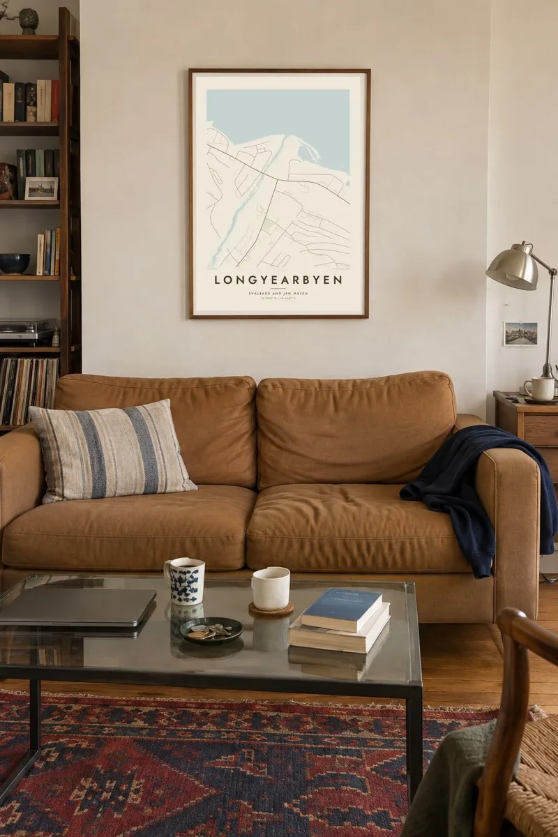

The map
Longyearbyen lies in a valley on the southern side of Adventfjorden, an arm of Isfjorden on the island of Spitsbergen. From above, the settlement stretches in a narrow band up the Longyear valley, following the river and the road. Steep, bare mountainsides rise on both sides. Towards the fjord the valley widens into a shoreline with a port and airport nearby.
The town was founded in 1906 by the American businessman John Munro Longyear as a coal mining settlement. It is now the administrative centre of Svalbard and among the northernmost towns in the world. Because the ground is permafrost, many buildings stand on stilts, and pipes run above ground. Not far from town, the Svalbard Global Seed Vault is built into a mountainside.
A Longyearbyen map poster is sparse and striking. A few roads follow the valley, the fjord opens broadly at one end, and large blank areas of mountain and tundra frame everything else. The settlement looks small against the landscape, which is exactly how it feels on the ground. It makes a clean, memorable Arctic print.
The settlement follows the valley floor between two mountainsides. Houses, roads and services are lined up along it in a long, narrow band.
A wide fjord opens at the lower end of the valley. On the map it forms the largest shape, giving the town its northern edge and its sense of space.
Longyearbyen's road network is very short and does not connect to other towns. On the poster the lines simply end where the valley and shoreline run out.
Make it yours
Add a date, a name or a line of your own, switch style, size or orientation.
The free preview is low-resolution with a watermark. Prints and HD files are rendered at 300 DPI, up to 7,200 × 10,800 px, without a watermark.
Why Longyearbyen
Longyearbyen is a once-in-a-lifetime destination for many people, and a home for a small, changing community of residents and researchers. A map of its valley and fjord captures the scale of the Arctic in a single calm image.
Personalise the title, subtitle and coordinates line with the date you arrived or a line about the polar night. Choose one of five styles: Classic black & white, Noir, Paper, Blueprint or Sand. Noir suits the dark season especially well.
Order the Longyearbyen poster| Print size | Resolution | Files |
|---|---|---|
| 30 × 40 cm11.8 × 15.7″ | 3,543 × 4,724 px | PNG · PDF |
| 29.7 × 42 cm (A3)11.7 × 16.5″ | 3,508 × 4,961 px | PNG · PDF |
| 42 × 59.4 cm (A2)16.5 × 23.4″ | 4,961 × 7,016 px | PNG · PDF |
| 45.7 × 61 cm18 × 24″ | 5,400 × 7,200 px | PNG · PDF |
| 50 × 70 cm19.7 × 27.6″ | 5,906 × 8,268 px | PNG · PDF |
| 61 × 91.4 cm24 × 36″ | 7,200 × 10,800 px | PNG · PDF |
For comparison, the free preview is 900 px wide, watermarked and meant for screens. The HD files have up to 8× the resolution in each direction and print cleanly at full poster size.
Pick a style at the top of the page, then choose Printed Poster — a size and, if you like, a frame — or Digital HD Files. Checkout takes one step, and your order page updates as soon as the payment goes through.
It is printed on premium 200 gsm matte paper in one of six sizes, from 30 × 40 cm to 24 × 36″. Printed posters start at $39, shipping included.
Yes. Choose a solid wood frame in black, white, natural oak or dark wood. It comes with shatterproof glazing and is ready to hang. Framed posters start at $99, shipping included.
Shipping is free to 60+ countries. Each poster is printed by the nearest of our print partners in 30+ countries and usually arrives in 3–7 business days. You can follow the status and tracking under My Orders. A few countries take 2–5 weeks, and where we don't ship yet, the site tells you before you pay.
Send us a photo within 14 days of delivery and we will reprint it for free or refund you.
Yes. In the editor on this page, change the title, the subtitle and the coordinates line to anything you like, and pick a style and size. Printed, framed and digital orders all use exactly your design.
For $9 you get 300 DPI PNG and print-ready PDF files in all six sizes, without a watermark, to print anywhere. Not sure yet? Download a free watermarked preview first.
Nearby
