RER A spine
The regional rail line runs east to west through all four sectors. Stations serve as centres, and the development follows the line like beads on a string.
Minimalist map poster · France
48.8358° N / 2.6424° E
A string of planned towns along the Marne and the RER A, stretching from the Paris suburbs to Disneyland
One city, five moods
Tap a style to see it on the wall. Every style costs the same — printed, framed or as HD files.
 Actual pixels · 24 × 36″ print file
Print-sharp
This is a 100% crop of the real print file. Every poster — printed, framed or downloaded — is rendered on our servers at 300 DPI, up to 7,200 × 10,800 pixels, so even the smallest lanes stay crisp on a 24 × 36″ print.
On the wall


The map
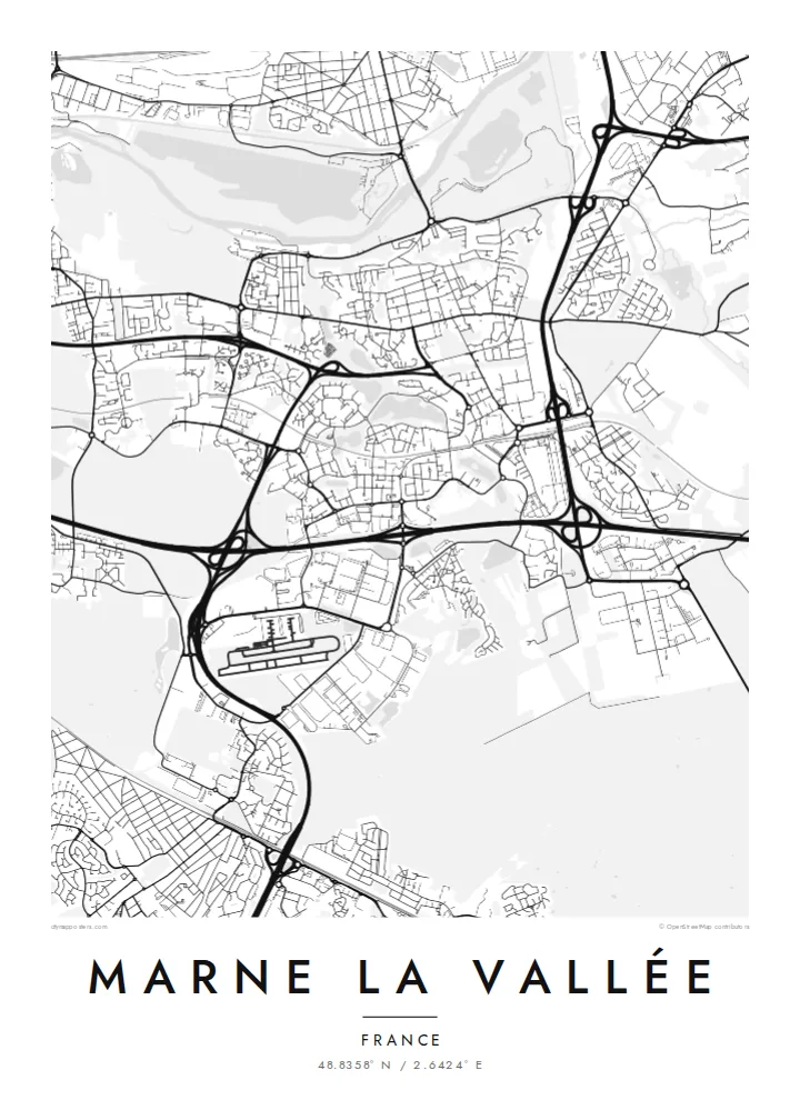
Marne-la-Vallée is not a traditional town but a new town, planned in the 1960s to relieve pressure on Paris. It stretches for more than twenty kilometres east of the capital in four sectors: Porte de Paris, Val Maubuée, Val de Bussy and Val d'Europe. The RER A line runs through them like a spine, with each sector clustered around its stations.
On a Marne La Vallée map poster, the Marne River winds along the northern side, with old riverside villages, while new districts lie on the plateau to the south. The planned areas are easy to spot. They have curved streets, cul-de-sacs, lakes and parks, and some unusual monumental housing, such as the Espaces d'Abraxas in Noisy-le-Grand.
The eastern end is dominated by Disneyland Paris, which opened in 1992 and shows up as a large, intricate cluster of loops and lakes. Further west, the Cité Descartes is a hub of universities and research. Between them, forests and farmland remain as green gaps that separate the sectors.
The regional rail line runs east to west through all four sectors. Stations serve as centres, and the development follows the line like beads on a string.
The resort at the eastern end forms a dense cluster of curving paths, lakes and parks. It is one of the most detailed shapes on the map.
The river winds along the northern edge with older villages on its banks. Its loops contrast with the planned layout of the newer sectors.
Make it yours
Add a date, a name or a line of your own, switch style, size or orientation.
The free preview is low-resolution with a watermark. Prints and HD files are rendered at 300 DPI, up to 7,200 × 10,800 px, without a watermark.
Why Marne La Vallée
Marne-la-Vallée is home to many families who have grown up with its lakes, parks and RER stations. It is also where many visitors spent a memorable day at Disneyland. A map shows the whole unusual shape of this planned territory.
Choose a title, such as the name of your own sector or commune, and add a subtitle and coordinates line. Pick Classic black & white, Noir, Paper, Blueprint or Sand. Get HD files for $9, or order a printed poster in a size of your choice.
Order the Marne La Vallée poster| Print size | Resolution | Files |
|---|---|---|
| 30 × 40 cm11.8 × 15.7″ | 3,543 × 4,724 px | PNG · PDF |
| 29.7 × 42 cm (A3)11.7 × 16.5″ | 3,508 × 4,961 px | PNG · PDF |
| 42 × 59.4 cm (A2)16.5 × 23.4″ | 4,961 × 7,016 px | PNG · PDF |
| 45.7 × 61 cm18 × 24″ | 5,400 × 7,200 px | PNG · PDF |
| 50 × 70 cm19.7 × 27.6″ | 5,906 × 8,268 px | PNG · PDF |
| 61 × 91.4 cm24 × 36″ | 7,200 × 10,800 px | PNG · PDF |
For comparison, the free preview is 900 px wide, watermarked and meant for screens. The HD files have up to 8× the resolution in each direction and print cleanly at full poster size.
Pick a style at the top of the page, then choose Printed Poster — a size and, if you like, a frame — or Digital HD Files. Checkout takes one step, and your order page updates as soon as the payment goes through.
It is printed on premium 200 gsm matte paper in one of six sizes, from 30 × 40 cm to 24 × 36″. Printed posters start at $39, shipping included.
Yes. Choose a solid wood frame in black, white, natural oak or dark wood. It comes with shatterproof glazing and is ready to hang. Framed posters start at $99, shipping included.
Shipping is free to 60+ countries. Each poster is printed by the nearest of our print partners in 30+ countries and usually arrives in 3–7 business days. You can follow the status and tracking under My Orders. A few countries take 2–5 weeks, and where we don't ship yet, the site tells you before you pay.
Send us a photo within 14 days of delivery and we will reprint it for free or refund you.
Yes. In the editor on this page, change the title, the subtitle and the coordinates line to anything you like, and pick a style and size. Printed, framed and digital orders all use exactly your design.
For $9 you get 300 DPI PNG and print-ready PDF files in all six sizes, without a watermark, to print anywhere. Not sure yet? Download a free watermarked preview first.
Nearby
