North Branch corridor
The river and its forest preserves run through the village as a long, winding strip of green. They split the grid into two halves.
Minimalist map poster · United States
42.0406° N / 87.7826° W
A leafy Chicago suburb split by the North Branch of the Chicago River and its long ribbons of forest preserve.


One city, five moods
Tap a style to see it on the wall. Every style costs the same — printed, framed or as HD files.
 Actual pixels · 24 × 36″ print file
Print-sharp
This is a 100% crop of the real print file. Every poster — printed, framed or downloaded — is rendered on our servers at 300 DPI, up to 7,200 × 10,800 pixels, so even the smallest lanes stay crisp on a 24 × 36″ print.
On the wall


The map
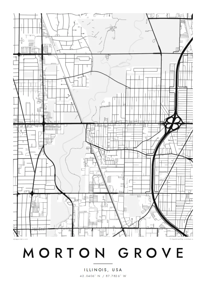
Morton Grove lies just north-west of Chicago in Cook County. On a map, it is a regular suburban grid of blocks and streets, cut through by a strong green corridor. The North Branch of the Chicago River runs roughly north to south through the village, bordered on both sides by forest preserve land. That band of trees and water divides the street grid into two parts.
The village grew around a railway stop, and the Metra line still runs diagonally through it. It shows on the map as a straight line cutting across the grid, with a small commercial area near the station. Main roads such as Dempster Street and Waukegan Road carry traffic through the village, lined with shops and services. Residential blocks fill most of the space between them.
A Morton Grove map poster shows the classic structure of an inner Chicago suburb: a grid, a railway, a few arterial streets and a river corridor that was kept as green space. The forest preserves give the composition a natural, winding contrast to the straight streets. They are what makes the village look different from its neighbours when seen from above.
The river and its forest preserves run through the village as a long, winding strip of green. They split the grid into two halves.
The Metra line crosses the grid at an angle, and the station area sits along it. This gives the map a clear directional line.
Dempster Street and Waukegan Road carry most of the traffic. They form a simple framework that the residential blocks fill in.
Make it yours
Add a date, a name or a line of your own, switch style, size or orientation.
The free preview is low-resolution with a watermark. Prints and HD files are rendered at 300 DPI, up to 7,200 × 10,800 px, without a watermark.
Why Morton Grove
Morton Grove is a place families stay in for decades, close to Chicago but with a lot of green. A map of it makes a warm gift for new homeowners or anyone who grew up walking the forest preserve trails.
Personalise the title, subtitle and coordinates, and choose from Classic black & white, Noir, Paper, Blueprint and Sand. The 300 DPI files are ready for any local print shop, or you can order a printed poster directly.
Order the Morton Grove poster| Print size | Resolution | Files |
|---|---|---|
| 30 × 40 cm11.8 × 15.7″ | 3,543 × 4,724 px | PNG · PDF |
| 29.7 × 42 cm (A3)11.7 × 16.5″ | 3,508 × 4,961 px | PNG · PDF |
| 42 × 59.4 cm (A2)16.5 × 23.4″ | 4,961 × 7,016 px | PNG · PDF |
| 45.7 × 61 cm18 × 24″ | 5,400 × 7,200 px | PNG · PDF |
| 50 × 70 cm19.7 × 27.6″ | 5,906 × 8,268 px | PNG · PDF |
| 61 × 91.4 cm24 × 36″ | 7,200 × 10,800 px | PNG · PDF |
For comparison, the free preview is 900 px wide, watermarked and meant for screens. The HD files have up to 8× the resolution in each direction and print cleanly at full poster size.
Pick a style at the top of the page, then choose Printed Poster — a size and, if you like, a frame — or Digital HD Files. Checkout takes one step, and your order page updates as soon as the payment goes through.
It is printed on premium 200 gsm matte paper in one of six sizes, from 30 × 40 cm to 24 × 36″. Printed posters start at $39, shipping included.
Yes. Choose a solid wood frame in black, white, natural oak or dark wood. It comes with shatterproof glazing and is ready to hang. Framed posters start at $99, shipping included.
Shipping is free to 60+ countries. Each poster is printed by the nearest of our print partners in 30+ countries and usually arrives in 3–7 business days. You can follow the status and tracking under My Orders. A few countries take 2–5 weeks, and where we don't ship yet, the site tells you before you pay.
Send us a photo within 14 days of delivery and we will reprint it for free or refund you.
Yes. In the editor on this page, change the title, the subtitle and the coordinates line to anything you like, and pick a style and size. Printed, framed and digital orders all use exactly your design.
For $9 you get 300 DPI PNG and print-ready PDF files in all six sizes, without a watermark, to print anywhere. Not sure yet? Download a free watermarked preview first.
Nearby
