Alssund crossing
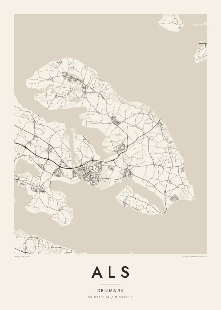
Bridges span the narrow sound between Als and Jutland at Sønderborg. They appear as short, clear strokes that tie the island firmly to the mainland.
Poster minimalist tal-mappa · id-Danimarka
54.9716° N / 9.8552° E
A green Baltic island curving around a fjord, joined to Jutland by bridges across a narrow sound at Sønderborg.




Belt waħda, ħames atmosferi
Agħfas fuq stil biex tarah fuq il-ħajt. Kull stil jiswa l-istess — stampat, inkurnat jew bħala fajls HD.
 Pixels reali · fajl tal-istampar 24 × 36″
Preċiż għall-istampar
Dan huwa qtugħ ta' 100% mill-fajl tal-istampar reali. Kull poster — stampat, inkurnat jew iddawnlowdjat — jiġi ġġenerat fuq is-servers tagħna b'300 DPI, sa 7,200 × 10,800 pixel, biex saħansitra l-iżgħar toroq jibqgħu ċari fuq stampa ta' 24 × 36″.
Fuq il-ħajt


Il-mappa
Als lies in the south of Denmark, separated from the Jutland mainland only by the narrow channel of Alssund. Its shape is compact but irregular. The long inlet of Als Fjord cuts into the north-west, and the interior is gently rolling farmland, woodland and small villages. From above, the roads form a loose web linking these villages rather than one main route.
The main town, Sønderborg, sits on both sides of Alssund, and its bridges are among the clearest lines on the map. The older centre and Sønderborg Castle are on the island side, while the town continues across the water toward Dybbøl. In the north, the town of Nordborg is home to the industrial company Danfoss, whose large site stands out among the fields.
Just across the sound from Sønderborg are the Dybbøl earthworks, where the decisive battle of the 1864 war was fought, a war that shaped the history of this border region. An Als map poster traces a quieter island beside that past: fjord shores, woodland, soft coastlines and a town whose two halves are joined by bridges.
Bridges span the narrow sound between Als and Jutland at Sønderborg. They appear as short, clear strokes that tie the island firmly to the mainland.
A long inlet reaches deep into the north-west of the island. It gives the outline a distinctive bite and a curving shoreline lined with farmland and woods.
The castle stands at the water's edge on the island side of the town. Nearby, the older street pattern gathers close to the harbour and the sound.
Agħmlu tiegħek
Żid data, isem jew sentenza tiegħek, ibdel l-istil, id-daqs jew l-orjentazzjoni.
Il-preview b'xejn hija b'riżoluzzjoni baxxa u bil-watermark. L-istampi u l-fajls HD jiġu ġġenerati b'300 DPI, sa 7,200 × 10,800 px, mingħajr watermark.
Għaliex Als
Als is home ground for many people in Sønderjylland and a familiar summer landscape for others. A map poster suits a family home on the island, a student who spent years at the university in Sønderborg, or a gift for someone who moved away.
You set the title, subtitle and coordinates, so the poster can carry a street name, a village or a date. Choose from five styles, including Paper and Sand for a softer look. Get it as HD files for $9 or as a printed poster with an optional frame.
Ordna l-poster Als| Daqs tal-istampa | Riżoluzzjoni | Fajls |
|---|---|---|
| 30 × 40 cm (11.8 × 15.7″) | 3,543 × 4,724 px | PNG · PDF |
| 29.7 × 42 cm (A3, 11.7 × 16.5″) | 3,508 × 4,961 px | PNG · PDF |
| 42 × 59.4 cm (A2, 16.5 × 23.4″) | 4,961 × 7,016 px | PNG · PDF |
| 45.7 × 61 cm (18 × 24″) | 5,400 × 7,200 px | PNG · PDF |
| 50 × 70 cm (19.7 × 27.6″) | 5,906 × 8,268 px | PNG · PDF |
| 61 × 91.4 cm (24 × 36″) | 7,200 × 10,800 px | PNG · PDF |
Għal paragun, il-preview b'xejn huwa wiesa' 900 px, għandu watermark u huwa maħsub għall-iskrins. Il-fajls HD għandhom sa 8× ir-riżoluzzjoni f'kull direzzjoni u jiġu stampati b'mod nadif fid-daqs sħiħ tal-poster.
Agħżel stil fin-naħa ta' fuq tal-paġna, imbagħad agħżel Poster Stampat — daqs u, jekk trid, kurniċa — jew Fajls Diġitali HD. Il-ħlas isir f'pass wieħed, u l-paġna tal-ordni tiegħek tiġi aġġornata malli l-ħlas jgħaddi.
Jiġi stampat fuq karta matte premium ta' 200 gsm f'wieħed minn sitt daqsijiet, minn 30 × 40 cm sa 24 × 36″. Il-posters stampati jibdew minn {printFrom}, bil-kunsinna inkluża.
Iva. Agħżel kurniċa tal-injam solidu f'iswed, abjad, ballut naturali jew injam skur. Tiġi bi ħġieġ li ma jinkisirx u lesta biex tittella'. Il-posters inkurnati jibdew minn {framedFrom}, bil-kunsinna inkluża.
Il-kunsinna hija b'xejn madwar id-dinja. Kull poster jiġi stampat mill-eqreb sieħeb tal-istampar tagħna f'aktar minn 30 pajjiż u ġeneralment jasal fi 3–7 ijiem tax-xogħol. Tista' ssegwi l-istatus u t-tracking taħt L-Ordnijiet Tiegħi.
Ibgħatilna ritratt fi żmien 14-il jum mill-kunsinna u aħna nistampawh mill-ġdid b'xejn jew nirrimborżawk.
Iva. Fl-editur ta' din il-paġna, biddel it-titlu, is-sottotitlu u l-linja tal-koordinati għal kwalunkwe ħaġa trid, u agħżel stil u daqs. L-ordnijiet stampati, inkurnati u diġitali kollha jużaw eżattament id-disinn tiegħek.
Għal $9 tikseb fajls PNG b'300 DPI u PDF lesti għall-istampar fis-sitt daqsijiet kollha, mingħajr watermark, biex tistampa kullimkien. Għadek mhux ċert? L-ewwel iddawnlowdja preview b'xejn bil-watermark.
