Twin bays
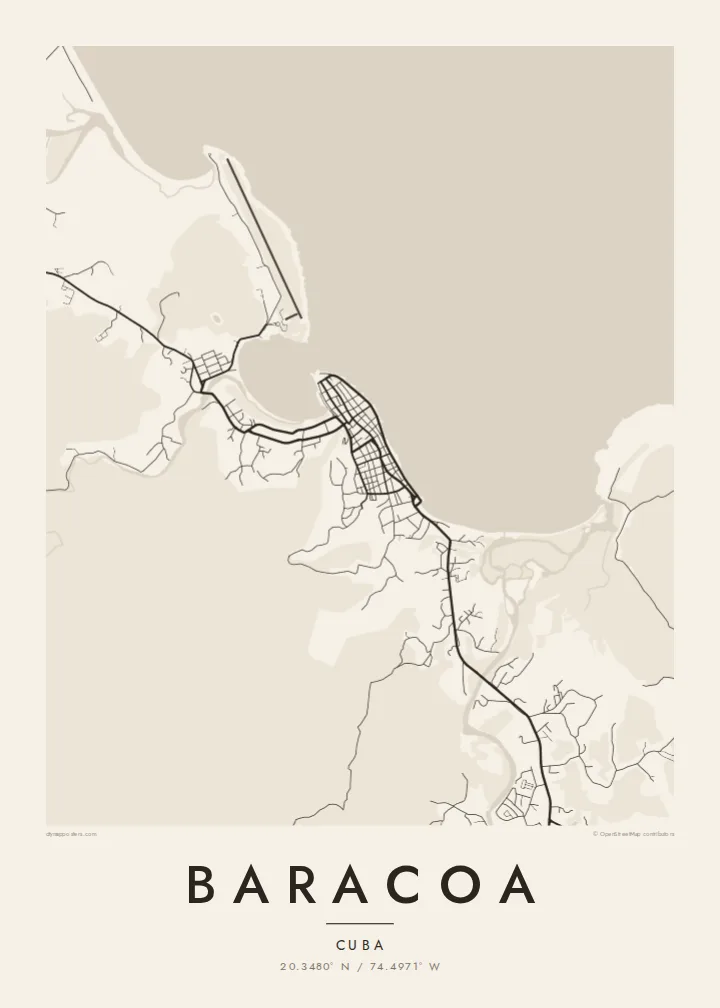
The town sits on a headland between two sheltered bays. Their curved shorelines give the northern and southern edges of the map a rounded shape that reads clearly even at small print sizes.
Poster minimalist tal-mappa · Kuba
20.3480° N / 74.4971° W
A small bayside grid on Cuba's far eastern tip, held between a curving seafront, river mouths and a flat-topped mountain




Belt waħda, ħames atmosferi
Agħfas fuq stil biex tarah fuq il-ħajt. Kull stil jiswa l-istess — stampat, inkurnat jew bħala fajls HD.
 Pixels reali · fajl tal-istampar 24 × 36″
Preċiż għall-istampar
Dan huwa qtugħ ta' 100% mill-fajl tal-istampar reali. Kull poster — stampat, inkurnat jew iddawnlowdjat — jiġi ġġenerat fuq is-servers tagħna b'300 DPI, sa 7,200 × 10,800 pixel, biex saħansitra l-iżgħar toroq jibqgħu ċari fuq stampa ta' 24 × 36″.
Fuq il-ħajt


Il-mappa
Baracoa sits at the eastern end of Cuba, on a short stretch of coast where the land bends toward the Windward Passage. From above, the town is a compact block of streets on a low point between two bays. A seafront road follows the open shore to the north, and rivers come down from the forested hills behind to meet the sea on either side of the centre.
The town's place in history is simple to state. It was the first settlement the Spanish founded in Cuba, in 1511, and it served for a short time as the island's first capital. For centuries it could only be reached by sea. That changed in the 1960s with La Farola, the mountain road that climbs over the ranges from the south coast and appears on the map as a single thin winding line.
A Baracoa map poster shows how little room the town has between water and slope. The grid is dense and short. The bays give it a soft, rounded outline, and the countryside inland dissolves into thin lanes and river courses. Printed in black and white, the difference between the orderly centre and the loose, open land around it is the first thing you notice.
The town sits on a headland between two sheltered bays. Their curved shorelines give the northern and southern edges of the map a rounded shape that reads clearly even at small print sizes.
West of town rises El Yunque, a flat-topped mountain that sailors used as a landmark. On the map it shows up as open ground inland, with only a few tracks crossing it.
The mountain road that finally connected Baracoa to the rest of Cuba winds south through the hills. Where the street network ends, its switchbacks stand out as one looping line.
Agħmlu tiegħek
Żid data, isem jew sentenza tiegħek, ibdel l-istil, id-daqs jew l-orjentazzjoni.
Il-preview b'xejn hija b'riżoluzzjoni baxxa u bil-watermark. L-istampi u l-fajls HD jiġu ġġenerati b'300 DPI, sa 7,200 × 10,800 px, mingħajr watermark.
Għaliex Baracoa
For many visitors, Baracoa is the part of Cuba that felt furthest from everything else: the end of a long road, a town facing the sea. A map of its few streets and two bays records that remoteness quietly, without needing a photograph.
You can set your own title, subtitle and coordinates line, which works well for a trip date or a family connection to Guantánamo Province. Choose Classic black & white, Noir, Paper, Blueprint or Sand. The file is $9 in HD, and printed posters ship from partners in more than 30 countries.
Ordna l-poster Baracoa| Daqs tal-istampa | Riżoluzzjoni | Fajls |
|---|---|---|
| 30 × 40 cm (11.8 × 15.7″) | 3,543 × 4,724 px | PNG · PDF |
| 29.7 × 42 cm (A3, 11.7 × 16.5″) | 3,508 × 4,961 px | PNG · PDF |
| 42 × 59.4 cm (A2, 16.5 × 23.4″) | 4,961 × 7,016 px | PNG · PDF |
| 45.7 × 61 cm (18 × 24″) | 5,400 × 7,200 px | PNG · PDF |
| 50 × 70 cm (19.7 × 27.6″) | 5,906 × 8,268 px | PNG · PDF |
| 61 × 91.4 cm (24 × 36″) | 7,200 × 10,800 px | PNG · PDF |
Għal paragun, il-preview b'xejn huwa wiesa' 900 px, għandu watermark u huwa maħsub għall-iskrins. Il-fajls HD għandhom sa 8× ir-riżoluzzjoni f'kull direzzjoni u jiġu stampati b'mod nadif fid-daqs sħiħ tal-poster.
Agħżel stil fin-naħa ta' fuq tal-paġna, imbagħad agħżel Poster Stampat — daqs u, jekk trid, kurniċa — jew Fajls Diġitali HD. Il-ħlas isir f'pass wieħed, u l-paġna tal-ordni tiegħek tiġi aġġornata malli l-ħlas jgħaddi.
Jiġi stampat fuq karta matte premium ta' 200 gsm f'wieħed minn sitt daqsijiet, minn 30 × 40 cm sa 24 × 36″. Il-posters stampati jibdew minn {printFrom}, bil-kunsinna inkluża.
Iva. Agħżel kurniċa tal-injam solidu f'iswed, abjad, ballut naturali jew injam skur. Tiġi bi ħġieġ li ma jinkisirx u lesta biex tittella'. Il-posters inkurnati jibdew minn {framedFrom}, bil-kunsinna inkluża.
L-ispedizzjoni hija b'xejn mad-dinja kollha. Kull poster jiġi stampat mill-eqreb wieħed mis-sieħba tal-istampar tagħna f'aktar minn 30 pajjiż u normalment jaslilek fi 3–7 ijiem tax-xogħol. Tista' tsegwi l-istatus u t-traċċar taħt L-Ordnijiet Tiegħi. Xi pajjiżi jieħdu 2–5 ġimgħat, u fejn għadna ma nispedixxux, is-sit jgħidlek qabel ma tħallas.
Ibgħatilna ritratt fi żmien 14-il jum mill-kunsinna u aħna nistampawh mill-ġdid b'xejn jew nirrimborżawk.
Iva. Fl-editur ta' din il-paġna, biddel it-titlu, is-sottotitlu u l-linja tal-koordinati għal kwalunkwe ħaġa trid, u agħżel stil u daqs. L-ordnijiet stampati, inkurnati u diġitali kollha jużaw eżattament id-disinn tiegħek.
Għal $9 tikseb fajls PNG b'300 DPI u PDF lesti għall-istampar fis-sitt daqsijiet kollha, mingħajr watermark, biex tistampa kullimkien. Għadek mhux ċert? L-ewwel iddawnlowdja preview b'xejn bil-watermark.
