Old town core
The historic centre forms a tight, irregular knot of streets along the main road. Its scale is very different from the planned residential streets built around it later.
Poster minimalist tal-mappa · il-Ġermanja
50.9149° N / 6.8118° E
A compact town on Cologne's western edge, framed by autobahns, rail lines and the long ridge of the Ville


Belt waħda, ħames atmosferi
Agħfas fuq stil biex tarah fuq il-ħajt. Kull stil jiswa l-istess — stampat, inkurnat jew bħala fajls HD.
 Pixels reali · fajl tal-istampar 24 × 36″
Preċiż għall-istampar
Dan huwa qtugħ ta' 100% mill-fajl tal-istampar reali. Kull poster — stampat, inkurnat jew iddawnlowdjat — jiġi ġġenerat fuq is-servers tagħna b'300 DPI, sa 7,200 × 10,800 pixel, biex saħansitra l-iżgħar toroq jibqgħu ċari fuq stampa ta' 24 × 36″.
Fuq il-ħajt


Il-mappa
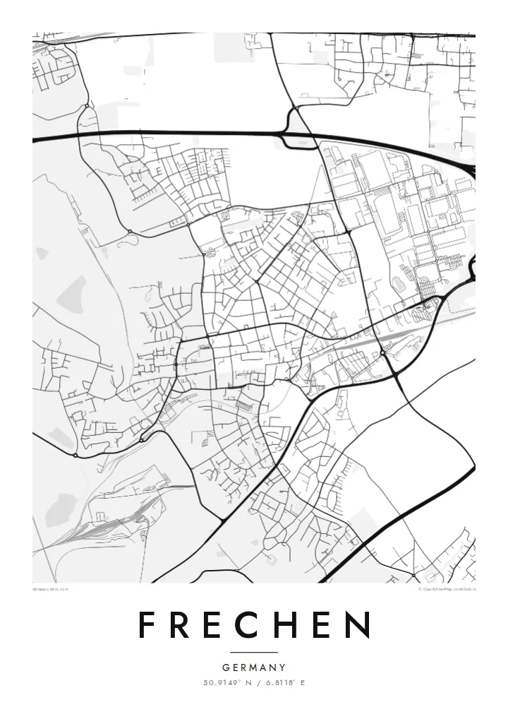
Frechen lies directly west of Cologne, and on the map the two almost touch. Frechen's centre is a compact cluster of streets around the old main road. Newer neighbourhoods and business parks fan out around it, and the A4 motorway and its interchanges make broad curves along the edge. To the west, the ground rises towards the Ville, a low wooded ridge shaped over decades by lignite mining.
Frechen is best known for its stoneware. From the late Middle Ages its potters made salt-glazed jugs, including the bearded Bartmann jugs, and exported them across Europe and beyond. Clay and lignite shaped the town's industry, and quarries, spoil heaps and reclaimed land still leave large, unusual shapes on the landscape.
A Frechen map poster shows that mix clearly: a dense old core, orderly residential streets, and the wide, sweeping lines of motorway and industrial land. In the Blueprint or Noir style, the contrast between the fine town grid and the large post-mining spaces becomes especially graphic.
The historic centre forms a tight, irregular knot of streets along the main road. Its scale is very different from the planned residential streets built around it later.
The A4 and its connecting roads draw long, smooth arcs across the map. They mark the transition between the town and the open land around it.
West of town, the landscape changes after years of lignite extraction. Recultivated land and large blocks of open space appear where the street pattern suddenly stops.
Agħmlu tiegħek
Żid data, isem jew sentenza tiegħek, ibdel l-istil, id-daqs jew l-orjentazzjoni.
Il-preview b'xejn hija b'riżoluzzjoni baxxa u bil-watermark. L-istampi u l-fajls HD jiġu ġġenerati b'300 DPI, sa 7,200 × 10,800 px, mingħajr watermark.
Għaliex Frechen
Frechen suits people who know it as a place close to Cologne that still has its own character: a potters' town, a mining town, a home town. The map captures that independence in one clear composition.
Add a name, a date or your own subtitle, and set the coordinates line. Choose from Classic black & white, Noir, Paper, Blueprint and Sand. Digital files cost $9 and come as a 300 DPI PNG and a print-ready PDF in each of the six sizes.
Ordna l-poster Frechen| Daqs tal-istampa | Riżoluzzjoni | Fajls |
|---|---|---|
| 30 × 40 cm (11.8 × 15.7″) | 3,543 × 4,724 px | PNG · PDF |
| 29.7 × 42 cm (A3, 11.7 × 16.5″) | 3,508 × 4,961 px | PNG · PDF |
| 42 × 59.4 cm (A2, 16.5 × 23.4″) | 4,961 × 7,016 px | PNG · PDF |
| 45.7 × 61 cm (18 × 24″) | 5,400 × 7,200 px | PNG · PDF |
| 50 × 70 cm (19.7 × 27.6″) | 5,906 × 8,268 px | PNG · PDF |
| 61 × 91.4 cm (24 × 36″) | 7,200 × 10,800 px | PNG · PDF |
Għal paragun, il-preview b'xejn huwa wiesa' 900 px, għandu watermark u huwa maħsub għall-iskrins. Il-fajls HD għandhom sa 8× ir-riżoluzzjoni f'kull direzzjoni u jiġu stampati b'mod nadif fid-daqs sħiħ tal-poster.
Agħżel stil fin-naħa ta' fuq tal-paġna, imbagħad agħżel Poster Stampat — daqs u, jekk trid, kurniċa — jew Fajls Diġitali HD. Il-ħlas isir f'pass wieħed, u l-paġna tal-ordni tiegħek tiġi aġġornata malli l-ħlas jgħaddi.
Jiġi stampat fuq karta matte premium ta' 200 gsm f'wieħed minn sitt daqsijiet, minn 30 × 40 cm sa 24 × 36″. Il-posters stampati jibdew minn {printFrom}, bil-kunsinna inkluża.
Iva. Agħżel kurniċa tal-injam solidu f'iswed, abjad, ballut naturali jew injam skur. Tiġi bi ħġieġ li ma jinkisirx u lesta biex tittella'. Il-posters inkurnati jibdew minn {framedFrom}, bil-kunsinna inkluża.
Il-kunsinna hija b'xejn madwar id-dinja. Kull poster jiġi stampat mill-eqreb sieħeb tal-istampar tagħna f'aktar minn 30 pajjiż u ġeneralment jasal fi 3–7 ijiem tax-xogħol. Tista' ssegwi l-istatus u t-tracking taħt L-Ordnijiet Tiegħi.
Ibgħatilna ritratt fi żmien 14-il jum mill-kunsinna u aħna nistampawh mill-ġdid b'xejn jew nirrimborżawk.
Iva. Fl-editur ta' din il-paġna, biddel it-titlu, is-sottotitlu u l-linja tal-koordinati għal kwalunkwe ħaġa trid, u agħżel stil u daqs. L-ordnijiet stampati, inkurnati u diġitali kollha jużaw eżattament id-disinn tiegħek.
Għal $9 tikseb fajls PNG b'300 DPI u PDF lesti għall-istampar fis-sitt daqsijiet kollha, mingħajr watermark, biex tistampa kullimkien. Għadek mhux ċert? L-ewwel iddawnlowdja preview b'xejn bil-watermark.
