Promenade des Anglais
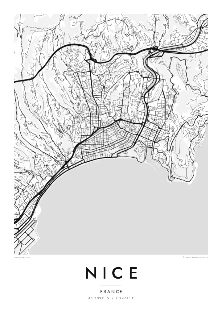
The seafront boulevard follows the Baie des Anges for several kilometres, drawing the city's defining curve from the airport to the foot of Castle Hill.
Poster minimalist tal-mappa · Franza
43.7031° N / 7.2661° E
A curved bay on the Riviera, with the Promenade des Anglais, a tight old town and hills climbing behind


Belt waħda, ħames atmosferi
Agħfas fuq stil biex tarah fuq il-ħajt. Kull stil jiswa l-istess — stampat, inkurnat jew bħala fajls HD.
 Pixels reali · fajl tal-istampar 24 × 36″
Preċiż għall-istampar
Dan huwa qtugħ ta' 100% mill-fajl tal-istampar reali. Kull poster — stampat, inkurnat jew iddawnlowdjat — jiġi ġġenerat fuq is-servers tagħna b'300 DPI, sa 7,200 × 10,800 pixel, biex saħansitra l-iżgħar toroq jibqgħu ċari fuq stampa ta' 24 × 36″.
Fuq il-ħajt


Il-mappa
Nice lies on the Baie des Anges, the Bay of Angels, on France's Mediterranean coast near the Italian border. Its map opens with one of the most recognisable waterfronts in Europe: the Promenade des Anglais, following the pebbled shore in a long, gentle curve from the airport towards the old town. Behind it the city climbs into hills of villas and winding roads.
At the eastern end of the bay, Vieux Nice packs narrow lanes into a dense triangle below Castle Hill, the rocky promontory that separates the old town from the port. The Paillon river, now covered, runs beneath a long green promenade that divides the old quarter from the nineteenth-century city with its broad streets and squares.
On the hill of Cimiez stand Roman remains and the Matisse Museum, and in 2021 Nice was added to UNESCO's World Heritage List as the winter resort town of the Riviera. A Nice map poster shows how clearly these layers fit together: the bay, the old town, the port, the green line of the Paillon and the hills above.
The seafront boulevard follows the Baie des Anges for several kilometres, drawing the city's defining curve from the airport to the foot of Castle Hill.
The old town's narrow, closely packed lanes create the densest texture on the map, a triangle of streets pressed between the sea, Castle Hill and the Paillon promenade.
East of Castle Hill the harbour forms a neat, nearly rectangular basin cut into the coast, surrounded by streets that slope up towards the hills.
Agħmlu tiegħek
Żid data, isem jew sentenza tiegħek, ibdel l-istil, id-daqs jew l-orjentazzjoni.
Il-preview b'xejn hija b'riżoluzzjoni baxxa u bil-watermark. L-istampi u l-fajls HD jiġu ġġenerati b'300 DPI, sa 7,200 × 10,800 px, mingħajr watermark.
Għaliex Nice
Nice is a city of holidays, long stays and new beginnings, loved by residents and visitors alike. Its map, with the sweep of the bay and the dense old town, makes a graceful reminder of a summer, a honeymoon or a first apartment by the sea.
Personalise the title, subtitle and coordinates line, and choose Classic black & white, Noir, Paper, Blueprint or Sand. Download HD files for $9, or order a matte printed poster from partners in 30+ countries, with an optional wooden frame.
Ordna l-poster Nice| Daqs tal-istampa | Riżoluzzjoni | Fajls |
|---|---|---|
| 30 × 40 cm (11.8 × 15.7″) | 3,543 × 4,724 px | PNG · PDF |
| 29.7 × 42 cm (A3, 11.7 × 16.5″) | 3,508 × 4,961 px | PNG · PDF |
| 42 × 59.4 cm (A2, 16.5 × 23.4″) | 4,961 × 7,016 px | PNG · PDF |
| 45.7 × 61 cm (18 × 24″) | 5,400 × 7,200 px | PNG · PDF |
| 50 × 70 cm (19.7 × 27.6″) | 5,906 × 8,268 px | PNG · PDF |
| 61 × 91.4 cm (24 × 36″) | 7,200 × 10,800 px | PNG · PDF |
Għal paragun, il-preview b'xejn huwa wiesa' 900 px, għandu watermark u huwa maħsub għall-iskrins. Il-fajls HD għandhom sa 8× ir-riżoluzzjoni f'kull direzzjoni u jiġu stampati b'mod nadif fid-daqs sħiħ tal-poster.
Agħżel stil fin-naħa ta' fuq tal-paġna, imbagħad agħżel Poster Stampat — daqs u, jekk trid, kurniċa — jew Fajls Diġitali HD. Il-ħlas isir f'pass wieħed, u l-paġna tal-ordni tiegħek tiġi aġġornata malli l-ħlas jgħaddi.
Jiġi stampat fuq karta matte premium ta' 200 gsm f'wieħed minn sitt daqsijiet, minn 30 × 40 cm sa 24 × 36″. Il-posters stampati jibdew minn {printFrom}, bil-kunsinna inkluża.
Iva. Agħżel kurniċa tal-injam solidu f'iswed, abjad, ballut naturali jew injam skur. Tiġi bi ħġieġ li ma jinkisirx u lesta biex tittella'. Il-posters inkurnati jibdew minn {framedFrom}, bil-kunsinna inkluża.
Il-kunsinna hija b'xejn madwar id-dinja. Kull poster jiġi stampat mill-eqreb sieħeb tal-istampar tagħna f'aktar minn 30 pajjiż u ġeneralment jasal fi 3–7 ijiem tax-xogħol. Tista' ssegwi l-istatus u t-tracking taħt L-Ordnijiet Tiegħi.
Ibgħatilna ritratt fi żmien 14-il jum mill-kunsinna u aħna nistampawh mill-ġdid b'xejn jew nirrimborżawk.
Iva. Fl-editur ta' din il-paġna, biddel it-titlu, is-sottotitlu u l-linja tal-koordinati għal kwalunkwe ħaġa trid, u agħżel stil u daqs. L-ordnijiet stampati, inkurnati u diġitali kollha jużaw eżattament id-disinn tiegħek.
Għal $9 tikseb fajls PNG b'300 DPI u PDF lesti għall-istampar fis-sitt daqsijiet kollha, mingħajr watermark, biex tistampa kullimkien. Għadek mhux ċert? L-ewwel iddawnlowdja preview b'xejn bil-watermark.
