Valley floor core
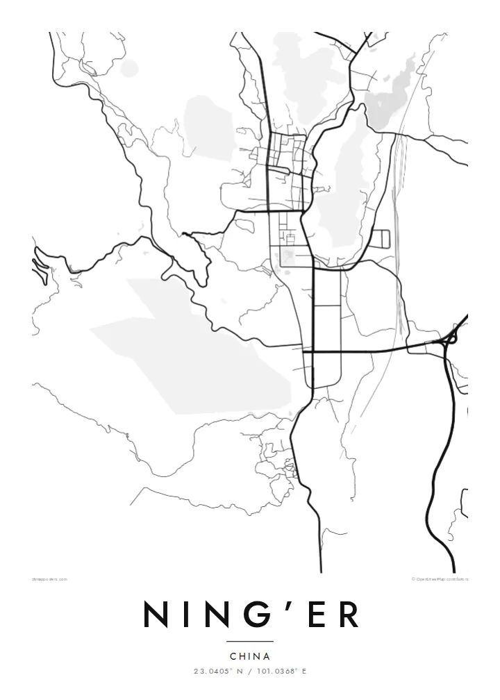
The densest streets sit on the flattest land in the basin, forming a tight cluster that stands out sharply against the open, lightly drawn hillsides around it.
Minimalist map poster · China
23.0405° N / 101.0368° E
A compact valley town on the Yunnan hills, its streets gathered in a narrow basin and ringed by folded tea country
One city, five moods
Tap a style to see it on the wall. Every style costs the same — printed, framed or as HD files.
 Actual pixels · 24 × 36″ print file
Print-sharp
This is a 100% crop of the real print file. Every poster — printed, framed or downloaded — is rendered on our servers at 300 DPI, up to 7,200 × 10,800 pixels, so even the smallest lanes stay crisp on a 24 × 36″ print.
On the wall


The map
Ning’er sits in the uplands of southern Yunnan, where hills rise on every side and a town has to fit into whatever flat ground it can find. From above, the streets pack into a valley floor, then give way to roads that wind up the slopes. The pattern follows the terrain closely, so the map reads almost like a contour drawing with a town at its centre.
The town was long known as Pu'er, and it gave its name to the fermented tea that traders carried out of these mountains along caravan routes. The county was renamed Ning’er in 2007, while the name Pu'er passed to the prefecture-level city that governs the area. The tea connection stays in the landscape, with terraced plantations on the surrounding hillsides.
A Ning’er map poster shows a place shaped by its setting more than by planning. The main streets follow the valley, the smaller ones branch off where the ground allows, and the outer roads loop into the hills. In black and white, that close fit between town and terrain becomes the whole composition: a dense core with lines unravelling into the mountains around it.
The densest streets sit on the flattest land in the basin, forming a tight cluster that stands out sharply against the open, lightly drawn hillsides around it.
Roads leaving town bend and switch back as they climb, drawing long curved lines that trace the shape of the slopes without any need for contour shading.
The hills around the town are tea-growing land, and the scattered lanes serving them give the edges of the map a loose, rural texture.
Make it yours
Add a date, a name or a line of your own, switch style, size or orientation.
The free preview is low-resolution with a watermark. Prints and HD files are rendered at 300 DPI, up to 7,200 × 10,800 px, without a watermark.
Why Ning’er
For anyone connected to Pu'er tea, or to this part of Yunnan, the town's outline is a quiet reminder of where the name began. It suits a kitchen, a study or a tea corner, where a simple drawing of a valley town says more than a photograph could.
You can add your own title, subtitle and coordinates line, perhaps a date or a family name, and choose from five styles: Classic black & white, Noir, Paper, Blueprint or Sand. The HD files cost $9, and printed posters on matte paper ship from partners in more than 30 countries.
Order the Ning’er poster| Print size | Resolution | Files |
|---|---|---|
| 30 × 40 cm11.8 × 15.7″ | 3,543 × 4,724 px | PNG · PDF |
| 29.7 × 42 cm (A3)11.7 × 16.5″ | 3,508 × 4,961 px | PNG · PDF |
| 42 × 59.4 cm (A2)16.5 × 23.4″ | 4,961 × 7,016 px | PNG · PDF |
| 45.7 × 61 cm18 × 24″ | 5,400 × 7,200 px | PNG · PDF |
| 50 × 70 cm19.7 × 27.6″ | 5,906 × 8,268 px | PNG · PDF |
| 61 × 91.4 cm24 × 36″ | 7,200 × 10,800 px | PNG · PDF |
For comparison, the free preview is 900 px wide, watermarked and meant for screens. The HD files have up to 8× the resolution in each direction and print cleanly at full poster size.
Pick a style at the top of the page, then choose Printed Poster — a size and, if you like, a frame — or Digital HD Files. Checkout takes one step, and your order page updates as soon as the payment goes through.
It is printed on premium 200 gsm matte paper in one of six sizes, from 30 × 40 cm to 24 × 36″. Printed posters start at $39, shipping included.
Yes. Choose a solid wood frame in black, white, natural oak or dark wood. It comes with shatterproof glazing and is ready to hang. Framed posters start at $99, shipping included.
Shipping is free to 60+ countries. Each poster is printed by the nearest of our print partners in 30+ countries and usually arrives in 3–7 business days. You can follow the status and tracking under My Orders. A few countries take 2–5 weeks, and where we don't ship yet, the site tells you before you pay.
Send us a photo within 14 days of delivery and we will reprint it for free or refund you.
Yes. In the editor on this page, change the title, the subtitle and the coordinates line to anything you like, and pick a style and size. Printed, framed and digital orders all use exactly your design.
For $9 you get 300 DPI PNG and print-ready PDF files in all six sizes, without a watermark, to print anywhere. Not sure yet? Download a free watermarked preview first.
Nearby
