Ring road
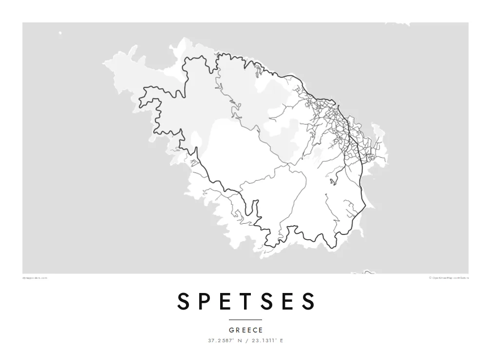
A single road circles almost the entire coast, a closed loop that holds the whole island together on the map and touches each of its bays.
Minimalist map poster · Greece
37.2587° N / 23.1311° E
A compact, rounded island at the mouth of the Argolic Gulf, circled by a single coastal road and wooded with pine.
One city, five moods
Tap a style to see it on the wall. Every style costs the same — printed, framed or as HD files.
 Actual pixels · 24 × 36″ print file
Print-sharp
This is a 100% crop of the real print file. Every poster — printed, framed or downloaded — is rendered on our servers at 300 DPI, up to 7,200 × 10,800 pixels, so even the smallest lanes stay crisp on a 24 × 36″ print.
On the wall


The island
Spetses lies just off the eastern tip of the Peloponnese, at the entrance to the Argolic Gulf, a short boat ride from the mainland village of Kosta. The island is small and roughly oval, its pine-covered hills rising gently toward the centre, and it is often counted among the Saronic islands. Private cars are restricted, so most people get around by scooter, bicycle, taxi or boat.
The town of Spetses spreads along the northeastern shore, from the Dapia waterfront past the Old Harbour, with lanes climbing the slopes behind. A coastal road loops around the island and links its bays and beaches, while the interior is mostly forest crossed by tracks. On a Spetses map poster, that loop forms a clean frame around the island's wooded centre.
The island's history is tied to the Greek War of Independence. Spetses was a significant naval power in 1821, and the naval commander Laskarina Bouboulina was based here; her house is now a museum. A battle from that war is re-enacted each September in the Armata festival. John Fowles taught at the island's Anargyrios and Korgialenios school, which inspired his novel The Magus.
A single road circles almost the entire coast, a closed loop that holds the whole island together on the map and touches each of its bays.
East of the main waterfront, the Old Harbour forms a narrow, sheltered inlet that has long served as a boatyard and mooring for traditional boats.
Behind the Dapia waterfront, a dense web of lanes climbs the hillside. It is the only part of the map where the linework becomes truly intricate.
Make it yours
Add a date, a name or a line of your own, switch style, size or orientation.
The free preview is low-resolution with a watermark. Prints and HD files are rendered at 300 DPI, up to 7,200 × 10,800 px, without a watermark.
Why Spetses
Spetses inspires strong loyalty among Athenian families who have summered there for decades, among sailors, and among readers who first met the island through The Magus. The rounded outline, circled by its road, makes one of the most graphic island maps in Greece.
Personalise the title, subtitle and coordinates line, perhaps with a house name or the year of a wedding on the island. Choose one of five styles, Classic black & white, Noir, Paper, Blueprint or Sand. Download the HD files for $9, or order a matte print with an optional wooden frame.
Order the Spetses poster| Print size | Resolution | Files |
|---|---|---|
| 30 × 40 cm11.8 × 15.7″ | 3,543 × 4,724 px | PNG · PDF |
| 29.7 × 42 cm (A3)11.7 × 16.5″ | 3,508 × 4,961 px | PNG · PDF |
| 42 × 59.4 cm (A2)16.5 × 23.4″ | 4,961 × 7,016 px | PNG · PDF |
| 45.7 × 61 cm18 × 24″ | 5,400 × 7,200 px | PNG · PDF |
| 50 × 70 cm19.7 × 27.6″ | 5,906 × 8,268 px | PNG · PDF |
| 61 × 91.4 cm24 × 36″ | 7,200 × 10,800 px | PNG · PDF |
For comparison, the free preview is 900 px wide, watermarked and meant for screens. The HD files have up to 8× the resolution in each direction and print cleanly at full poster size.
Pick a style at the top of the page, then choose Printed Poster — a size and, if you like, a frame — or Digital HD Files. Checkout takes one step, and your order page updates as soon as the payment goes through.
It is printed on premium 200 gsm matte paper in one of six sizes, from 30 × 40 cm to 24 × 36″. Printed posters start at $39, shipping included.
Yes. Choose a solid wood frame in black, white, natural oak or dark wood. It comes with shatterproof glazing and is ready to hang. Framed posters start at $99, shipping included.
Shipping is free to 60+ countries. Each poster is printed by the nearest of our print partners in 30+ countries and usually arrives in 3–7 business days. You can follow the status and tracking under My Orders. A few countries take 2–5 weeks, and where we don't ship yet, the site tells you before you pay.
Send us a photo within 14 days of delivery and we will reprint it for free or refund you.
Yes. In the editor on this page, change the title, the subtitle and the coordinates line to anything you like, and pick a style and size. Printed, framed and digital orders all use exactly your design.
For $9 you get 300 DPI PNG and print-ready PDF files in all six sizes, without a watermark, to print anywhere. Not sure yet? Download a free watermarked preview first.
Nearby
