The numbered lines
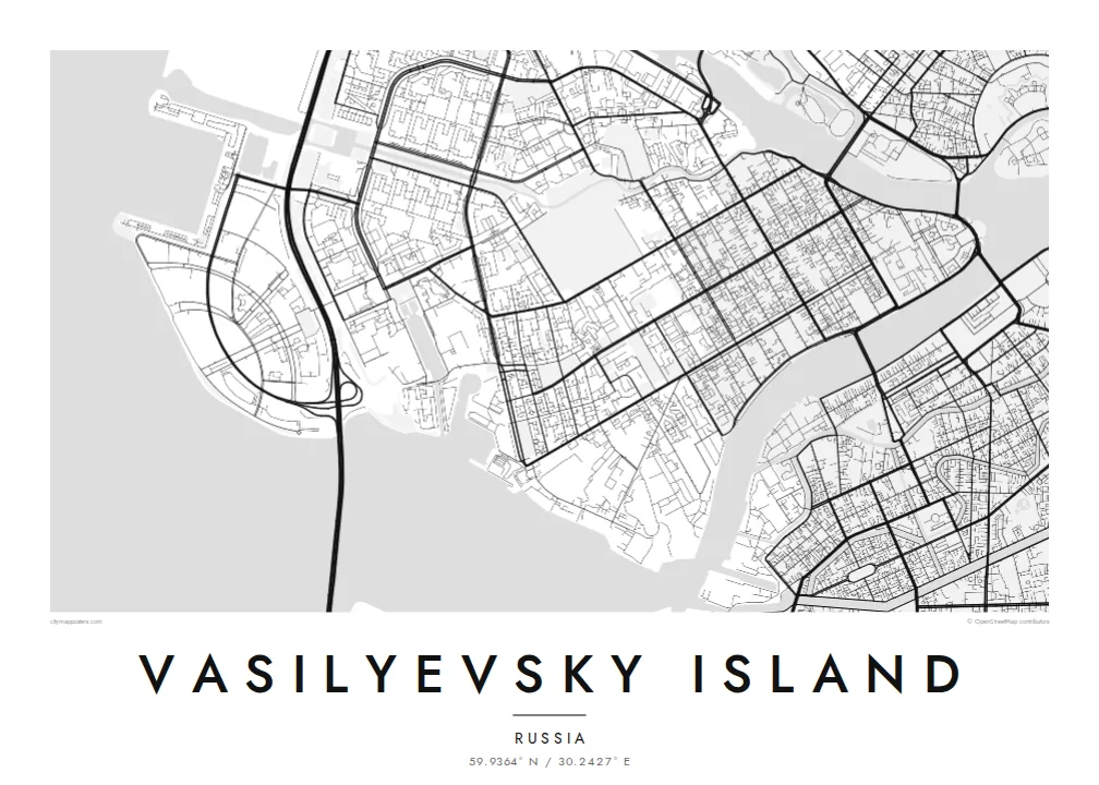
Parallel streets run across the island from north to south, and each side of a street has its own line number. The result is one of the clearest grids on any European map.
Minimalist map poster · Russia
59.9364° N / 30.2427° E
A wedge of land splitting the Neva in St Petersburg, laid out in numbered lines crossed by three long avenues.
One city, five moods
Tap a style to see it on the wall. Every style costs the same — printed, framed or as HD files.
 Actual pixels · 24 × 36″ print file
Print-sharp
This is a 100% crop of the real print file. Every poster — printed, framed or downloaded — is rendered on our servers at 300 DPI, up to 7,200 × 10,800 pixels, so even the smallest lanes stay crisp on a 24 × 36″ print.
On the wall


The island
Vasilyevsky Island is the largest island in St Petersburg's delta. It lies between the Bolshaya Neva and the Malaya Neva, across the river from the Winter Palace. Its eastern tip, the Strelka, points straight at the heart of the city. The western shore opens onto the Gulf of Finland, where newer districts have been built on reclaimed land.
The island has one of the most distinctive street plans in Europe. It was laid out as a grid in the early eighteenth century, and its north–south streets are still called lines, with each side of a street numbered separately. Three avenues, Bolshoy, Sredny and Maly, cross the grid from east to west. At the Strelka, the former Stock Exchange stands between two red Rostral Columns.
A Vasilyevsky Island map poster sets that strict grid against the soft curves of the river, with bridges reaching across to the Admiralty side and to the Petrograd Side. It is a favourite for anyone who studied at the university on the embankment, walked the Strelka at night, or simply loves a city plan that reads like a diagram.
Parallel streets run across the island from north to south, and each side of a street has its own line number. The result is one of the clearest grids on any European map.
The island's eastern point splits the Neva into two arms. The Rostral Columns and the old Stock Exchange face the Winter Palace across the water.
The Bolshoy, Sredny and Maly avenues cross the grid from east to west and give the plan its strong horizontal structure between the two branches of the Neva.
Make it yours
Add a date, a name or a line of your own, switch style, size or orientation.
The free preview is low-resolution with a watermark. Prints and HD files are rendered at 300 DPI, up to 7,200 × 10,800 px, without a watermark.
Why Vasilyevsky Island
People hang Vasilyevsky Island because they lived on one of its lines, studied there, or remember watching the bridges open at night from the Strelka. Even without a personal link, the grid set against the river is one of the most satisfying city shapes to frame.
Add a title such as a street address or a line number, a subtitle and your own coordinates, then choose from five styles. Noir and Blueprint suit the geometric plan well. HD digital files cost $9, and printed posters on matte paper ship from partners in more than 30 countries.
Order the Vasilyevsky Island poster| Print size | Resolution | Files |
|---|---|---|
| 30 × 40 cm11.8 × 15.7″ | 3,543 × 4,724 px | PNG · PDF |
| 29.7 × 42 cm (A3)11.7 × 16.5″ | 3,508 × 4,961 px | PNG · PDF |
| 42 × 59.4 cm (A2)16.5 × 23.4″ | 4,961 × 7,016 px | PNG · PDF |
| 45.7 × 61 cm18 × 24″ | 5,400 × 7,200 px | PNG · PDF |
| 50 × 70 cm19.7 × 27.6″ | 5,906 × 8,268 px | PNG · PDF |
| 61 × 91.4 cm24 × 36″ | 7,200 × 10,800 px | PNG · PDF |
For comparison, the free preview is 900 px wide, watermarked and meant for screens. The HD files have up to 8× the resolution in each direction and print cleanly at full poster size.
Pick a style at the top of the page, then choose Printed Poster — a size and, if you like, a frame — or Digital HD Files. Checkout takes one step, and your order page updates as soon as the payment goes through.
It is printed on premium 200 gsm matte paper in one of six sizes, from 30 × 40 cm to 24 × 36″. Printed posters start at $39, shipping included.
Yes. Choose a solid wood frame in black, white, natural oak or dark wood. It comes with shatterproof glazing and is ready to hang. Framed posters start at $99, shipping included.
Shipping is free to 60+ countries. Each poster is printed by the nearest of our print partners in 30+ countries and usually arrives in 3–7 business days. You can follow the status and tracking under My Orders. A few countries take 2–5 weeks, and where we don't ship yet, the site tells you before you pay.
Send us a photo within 14 days of delivery and we will reprint it for free or refund you.
Yes. In the editor on this page, change the title, the subtitle and the coordinates line to anything you like, and pick a style and size. Printed, framed and digital orders all use exactly your design.
For $9 you get 300 DPI PNG and print-ready PDF files in all six sizes, without a watermark, to print anywhere. Not sure yet? Download a free watermarked preview first.
Nearby
