San Juan and San Francisco
The two oldest quarters form a tight knot of narrow, irregular streets. They are clearly distinguishable from the more regular modern districts around them.
Ata mapa faigafua · Spain
27.9924° N / 15.4192° W
Gran Canaria's second city, spreading from two historic quarters down a slope of ravines to the eastern coast.



Kolo e tahi, lanu e nima
Tuki he sitaili ke sio ai ʻi te holo. ʻE tatau pē te totogi ʻo te sitaili fuli pē — mokā tā, fakakātoa, peʻe ko he ʻu faila HD.
 Ngaahi pikiseli moʻoni · faila tā 24 × 36″
Mahino lelei ki te pulūti
Ko he konga 100% ʻo te faila tā moʻoni ʻaeni. Ko te ʻu posita fuli pē — mokā tā, fakakātoa peʻe download — ʻe fakatupu ʻi ʻomātou seva ʻi te 300 DPI, aʻu ki te 7,200 × 10,800 pikiseli, koia ʻe nofo mahino ai te ʻu ala liliki ʻi he tā 24 × 36″.
ʻI Te Puipui


Te mapa
Telde lies on the eastern side of Gran Canaria, between the island's central highlands and the Atlantic. It is the second-largest municipality on the island. Instead of one compact core it forms a string of districts. They spread across a gently sloping landscape cut by ravines, or barrancos, that run from the hills down to the shore.
Before the Castilian conquest, Telde was one of the island's two indigenous seats of power. Its oldest quarters, San Juan and San Francisco, keep narrow streets and low whitewashed houses, and the Basilica of San Juan Bautista stands at the centre of the former. The coastline includes beaches such as Melenara and La Garita, and Gran Canaria Airport lies just to the south.
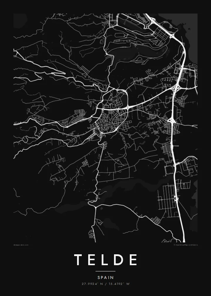
A Telde map poster shows a scattered, layered city. There is a historic centre inland, with separate districts spreading across the slope, dry ravines between them, and a rocky coastline along the eastern edge. It is more complex than a typical grid, and that is its appeal.
The two oldest quarters form a tight knot of narrow, irregular streets. They are clearly distinguishable from the more regular modern districts around them.
Dry barrancos run down from the interior to the sea. They leave open corridors that separate the neighbourhoods and give the map strong diagonal lines.
The eastern coast is a series of small bays and headlands. It gives the poster an irregular, detailed edge, with the beach districts clustered along it.
Faʻu ke ʻau ʻa ʻau
Tuku he ʻaho, he hingoa peʻe he kiʻi palalau ʻa ʻau, fetogi te faʻahiga, te lahi peʻe te hake.
Ko te faʻata fua noa ʻe māʻulalo hono lelei pea ʻe ʻi ai he fakaʻilonga. Ko te ʻu tā mo te ʻu faila HD ʻe fakatupu ʻi te 300 DPI, aʻu ki te 7,200 × 10,800 px, ʻe mole ʻi ai he fakaʻilonga.
Koteā ko Telde
Telde is home for many Canarians and a familiar stop for people who know Gran Canaria beyond the resorts. A print of its districts and ravines is a genuine piece of the island.
Personalise the title, subtitle and coordinates line. The Sand style suits the island's dry landscape, and Noir gives a more modern look. The HD files include six print sizes, and a free watermarked preview is available first.
Fakatau te posita Telde| Lahi ʻo te pulūti | Mahino | Faile |
|---|---|---|
| 30 × 40 cm (11.8 × 15.7″) | 3,543 × 4,724 px | PNG · PDF |
| 29.7 × 42 cm (A3, 11.7 × 16.5″) | 3,508 × 4,961 px | PNG · PDF |
| 42 × 59.4 cm (A2, 16.5 × 23.4″) | 4,961 × 7,016 px | PNG · PDF |
| 45.7 × 61 cm (18 × 24″) | 5,400 × 7,200 px | PNG · PDF |
| 50 × 70 cm (19.7 × 27.6″) | 5,906 × 8,268 px | PNG · PDF |
| 61 × 91.4 cm (24 × 36″) | 7,200 × 10,800 px | PNG · PDF |
Ko te ata ʻe mole totogi ʻe 900 px tona laulahi, mo te fakaʻilonga, ki te sioʻata pē. Ko te ʻu faile HD ʻe aʻu ki te liuga 8 tona mahino, pea ʻe pulūti lelei ʻi te lahi kātoa.
Fili he sitaili ʻi te tuʻa ʻo te pasina, pea fili leva te Posita Tā — he lahi pea, kapau ʻe ke loto ai, he fakakātoa — peʻe ko te ʻu Faila HD Fakakomipiuta. ʻE tahi pē te sitepu ʻo te totogi, pea ʻe fakafou fakavavevave pē tau pasina fakatau mai te taimi ʻe fai ai te totogi.
ʻE tā ʻi he pepa lelei ʻaupito 200 gsm matte, ʻi he tahi ʻo te ono lahi, mai te 30 × 40 cm ki te 24 × 36″. ʻE kamata te ʻu posita tā ʻi te {printFrom}, kātoa mo te ʻave.
ʻIo. Fili he fakakātoa ʻakau moʻoni ʻi te kili, hinahina, ʻakau natula peʻe ʻakau ʻuliʻuli. ʻE ʻi ai mo he sioga mālohi ʻe mole mafesi, pea kua teu ke tautau. ʻE kamata te ʻu posita fakakātoa ʻi te {framedFrom}, kātoa mo te ʻave.
ʻE fua noa te ʻave ki te lalolagi kātoa. ʻE tā takitaha posita e te kaugā tā ʻe ovi ki ai ʻi te lolotoga ʻo te ʻu puleʻanga e 30 tupu, pea ʻe aʻu mai tuʻumaʻu ʻi te ʻaho gāue e 3 ki te 7. ʻE feala ke ke sio ki te tuʻu pea mo te ʻalu ʻi lalo ʻo Taku ʻu Fakatau.
Fekau mai he ʻata ʻi loto ʻi te ʻaho e 14 talu mai te aʻu mai, pea mātou toe tā noa peʻe toe totogi atu.
ʻIo. ʻI te meʻa fakatonutonu ʻi te pasina ʻaeni, fetogi te kupu tāfito, te kupu lalo pea mo te laina koʻoliteti ki he meʻa fuli pē ʻe ke loto ai, pea fili he sitaili mo he lahi. Ko te ʻu fakatau tā, fakakātoa mo fakakomipiuta ʻe fakaʻaogaʻi katoa pē tou fakatātā.
Mo te $9 ʻe ke maʻu ai te ʻu faila PNG 300 DPI mo PDF kua teu ke tā, ʻi te ono lahi kātoa, ʻe mole ʻi ai he fakaʻilonga, ke ke tā ai ʻi soʻo he potu. Kei tā fakafiafia? Download muʻa he faʻata mokā mo he fakaʻilonga, ʻe fua noa.
