Two ring roads
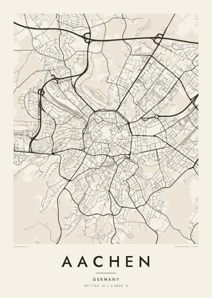
The Grabenring and the Alleenring trace the inner and outer lines of the former fortifications, giving the centre a layered, almost tree-ring look on the printed sheet.
Minimalist map poster · Germany
A cathedral at the centre, two concentric rings of road around it, and forest rolling toward three borders.
50.7766° N / 6.0834° E




One city, five moods
Tap a style to see it on the wall. Every style is included in the same $9 price.
 Actual pixels · 24 × 36″ HD file
Print-sharp
This is a crop of the real HD file at 100%. The paid download is rendered on our servers at 300 DPI, up to 7,200 × 10,800 pixels, so even the smallest lanes stay crisp on a 24 × 36″ print.
The map
Aachen sits in the far west of Germany, where the country meets Belgium and the Netherlands a few kilometres from the old town. From above, the city reads as a set of rings: a tight inner loop and a wider outer boulevard, both following lines where medieval walls once stood. Streets run inward from every direction toward the cathedral and town hall, which sit a short walk apart on the central hill.
Charlemagne made Aachen his favoured residence around the year 800, and his Palatine Chapel became the core of the cathedral, one of the first sites in Germany added to the UNESCO World Heritage list. Warm springs rise beneath the city, which is why it has been a spa town since Roman times and why several of its place names refer to baths.
An Aachen map poster shows the difference between that compact medieval centre and the larger blocks laid out as the city grew beyond its walls. To the north and west, the grounds of RWTH Aachen University spread across whole districts, while the southern edge dissolves into the Aachener Wald, a wooded upland that carries the street pattern right up to the border.
The Grabenring and the Alleenring trace the inner and outer lines of the former fortifications, giving the centre a layered, almost tree-ring look on the printed sheet.
At the heart of the rings, the cathedral and the town hall face each other across a cluster of small squares, the densest knot of lanes anywhere on the map.
The Aachener Wald covers the hills south of the city, a wide open area crossed only by trails and a few roads heading toward Belgium.
Make it yours
Add a date, a name or a line of your own, switch style, size or orientation.
Free preview is low-resolution with a watermark. The HD version is 7,200 × 10,800 px, 300 DPI, no watermark.
Why Aachen
People hang Aachen for a degree finished at the university, a few years spent near the border, or a family connection to the old spa town. The rings make a strong centrepiece, readable at a glance even in a small frame.
You can set the title, subtitle and coordinates line yourself, adding a name or a date, and choose between Classic black & white, Noir, Paper, Blueprint and Sand. The digital files cost $9, or you can order a printed poster, framed if you like.
Get the Aachen poster — $9| Print size | Resolution | Files |
|---|---|---|
| 30 × 40 cm | 3,543 × 4,724 px | PNG · PDF |
| 50 × 70 cm | 5,906 × 8,268 px | PNG · PDF |
| A3 · 29.7 × 42 cm | 3,508 × 4,961 px | PNG · PDF |
| A2 · 42 × 59.4 cm | 4,961 × 7,016 px | PNG · PDF |
| 18 × 24" | 5,400 × 7,200 px | PNG · PDF |
| 24 × 36" | 7,200 × 10,800 px | PNG · PDF |
For comparison, the free preview is 900 px wide, watermarked and meant for screens. The HD files have up to 8× the resolution in each direction and print cleanly at full poster size.
Yes. Drag and zoom the map in the editor — centre it on your neighbourhood, the old town or the whole metro area. The text updates independently.
The HD purchase includes 30×40 cm, 50×70 cm, A3, A2, 18×24″ and 24×36″, each as a 300 DPI PNG and a print-ready PDF.
You can download a free 900 px preview with a watermark. The paid HD files have no watermark and are sharp enough for large prints.
Send the PDF to any local print shop or online printing service and ask for the matching paper size. Matte paper and a thin black or oak frame suit this style best.
Nearby
