Las Cabezas headland
The northeastern tip of the island ends in a rocky headland crowned by a nineteenth-century lighthouse and surrounded by protected coastal habitats.
Minimalist map poster · Puerto Rico
18.3258° N / 65.6524° W
The northeastern corner of Puerto Rico, where marinas, mangroves and a lighthouse headland face the offshore cays.

One city, five moods
Tap a style to see it on the wall. Every style costs the same — printed, framed or as HD files.
 Actual pixels · 24 × 36″ print file
Print-sharp
This is a 100% crop of the real print file. Every poster — printed, framed or downloaded — is rendered on our servers at 300 DPI, up to 7,200 × 10,800 pixels, so even the smallest lanes stay crisp on a 24 × 36″ print.
On the wall
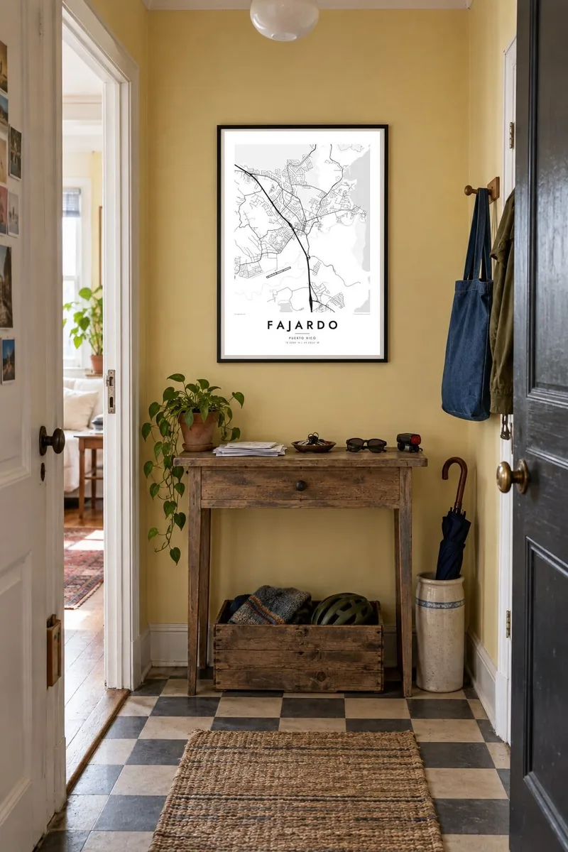


The map
Fajardo occupies the northeastern corner of Puerto Rico, where the island's coastline turns from the Atlantic toward the waters facing Culebra, Vieques and the Virgin Islands. On a map the town centre sits a little inland, with its grid of streets around the main plaza, while the coast beyond is lined with harbours, beaches, mangroves and small islands scattered offshore.
The town is one of Puerto Rico's main boating centres. Large marinas fill sheltered stretches of shoreline, and their piers and basins appear on the map as intricate, comb-like shapes. Fajardo has long served as a departure point for boats to the smaller islands and cays of the east, which makes it familiar to sailors and day-trippers alike.
At the northern tip lies the Las Cabezas de San Juan nature reserve, with its historic lighthouse and Laguna Grande, one of the island's bioluminescent lagoons. A Fajardo map poster brings together this complex coastline, the headland, lagoon and marinas, with the town grid behind them, a composition as much about water as about land.
The northeastern tip of the island ends in a rocky headland crowned by a nineteenth-century lighthouse and surrounded by protected coastal habitats.
The bioluminescent lagoon behind the headland appears as a smooth enclosed shape, linked to the sea by a mangrove channel where visitors paddle at night.
Along the eastern shore, breakwaters, piers and boat basins create sharp, geometric forms against the natural curves of the coast on the map.
Make it yours
Add a date, a name or a line of your own, switch style, size or orientation.
The free preview is low-resolution with a watermark. Prints and HD files are rendered at 300 DPI, up to 7,200 × 10,800 px, without a watermark.
Why Fajardo
Fajardo means sailing, night kayaking, island trips and, for many, home. A map of this corner of Puerto Rico makes a strong reminder of a holiday or of a lasting tie to the island and its eastern coast.
Personalise the title and subtitle, perhaps with the date of a trip, and choose from five styles, with Blueprint showing the coastline especially clearly. Each $9 download includes six sizes, from 18×24″ to 50×70 cm.
Order the Fajardo poster| Print size | Resolution | Files |
|---|---|---|
| 30 × 40 cm11.8 × 15.7″ | 3,543 × 4,724 px | PNG · PDF |
| 29.7 × 42 cm (A3)11.7 × 16.5″ | 3,508 × 4,961 px | PNG · PDF |
| 42 × 59.4 cm (A2)16.5 × 23.4″ | 4,961 × 7,016 px | PNG · PDF |
| 45.7 × 61 cm18 × 24″ | 5,400 × 7,200 px | PNG · PDF |
| 50 × 70 cm19.7 × 27.6″ | 5,906 × 8,268 px | PNG · PDF |
| 61 × 91.4 cm24 × 36″ | 7,200 × 10,800 px | PNG · PDF |
For comparison, the free preview is 900 px wide, watermarked and meant for screens. The HD files have up to 8× the resolution in each direction and print cleanly at full poster size.
Pick a style at the top of the page, then choose Printed Poster — a size and, if you like, a frame — or Digital HD Files. Checkout takes one step, and your order page updates as soon as the payment goes through.
It is printed on premium 200 gsm matte paper in one of six sizes, from 30 × 40 cm to 24 × 36″. Printed posters start at $39, shipping included.
Yes. Choose a solid wood frame in black, white, natural oak or dark wood. It comes with shatterproof glazing and is ready to hang. Framed posters start at $99, shipping included.
Shipping is free to 60+ countries. Each poster is printed by the nearest of our print partners in 30+ countries and usually arrives in 3–7 business days. You can follow the status and tracking under My Orders. A few countries take 2–5 weeks, and where we don't ship yet, the site tells you before you pay.
Send us a photo within 14 days of delivery and we will reprint it for free or refund you.
Yes. In the editor on this page, change the title, the subtitle and the coordinates line to anything you like, and pick a style and size. Printed, framed and digital orders all use exactly your design.
For $9 you get 300 DPI PNG and print-ready PDF files in all six sizes, without a watermark, to print anywhere. Not sure yet? Download a free watermarked preview first.
Nearby
