The planned new town
Residential districts built in the GDR era show up as rhythmic rows of long blocks with generous open space, one of the most distinctive patterns of post-war planning in Germany.
Minimalist map poster · Germany
51.4379° N / 14.2355° E
A small old town on the Black Elster beside a large planned new town of long housing blocks and wide green courtyards
One city, five moods
Tap a style to see it on the wall. Every style costs the same — printed, framed or as HD files.
 Actual pixels · 24 × 36″ print file
Print-sharp
This is a 100% crop of the real print file. Every poster — printed, framed or downloaded — is rendered on our servers at 300 DPI, up to 7,200 × 10,800 pixels, so even the smallest lanes stay crisp on a 24 × 36″ print.
On the wall


The map
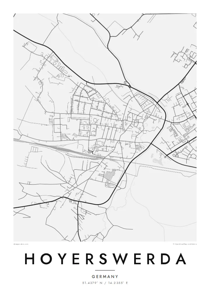
Hoyerswerda lies in Upper Lusatia in eastern Saxony, on the Black Elster river. From above it looks like two towns side by side. A compact old centre with a castle and market square sits near the river, and next to it spreads a much larger new town, laid out in the GDR era in residential districts of long parallel blocks with open green space between them.
The new town was built to house workers for the Schwarze Pumpe lignite and energy complex. After 1990 the population fell sharply and many blocks were demolished, so some districts on the map now look more open than their plan intended. The area is bilingual German and Sorbian, and the computer pioneer Konrad Zuse spent his school years here.
A Hoyerswerda map poster shows modernist planning on a scale few towns share: regular rows, broad through-roads and clear neighbourhood units, set beside the tighter streets of the older centre. Around the edges, forest and the new flooded lakes of the former mining district begin to appear, softening the geometry.
Residential districts built in the GDR era show up as rhythmic rows of long blocks with generous open space, one of the most distinctive patterns of post-war planning in Germany.
Close to the Black Elster, the historic centre keeps a denser, older street pattern around the market and the castle, a small contrast to the new districts next door.
Outside the town, pine forest and lakes created from former open-cast mines surround the built area, giving the map irregular water shapes around its edges.
Make it yours
Add a date, a name or a line of your own, switch style, size or orientation.
The free preview is low-resolution with a watermark. Prints and HD files are rendered at 300 DPI, up to 7,200 × 10,800 px, without a watermark.
Why Hoyerswerda
Hoyerswerda means a lot to people who grew up in its new town or moved away after the 1990s. A map captures the layout they knew, including streets and blocks that may since have changed, as a considered record of a place with an unusual story.
You can personalise the title, subtitle and coordinates line, for example with a district name or year, and choose one of five styles: Classic black & white, Noir, Paper, Blueprint or Sand. Blueprint suits the planned geometry especially well.
Order the Hoyerswerda poster| Print size | Resolution | Files |
|---|---|---|
| 30 × 40 cm11.8 × 15.7″ | 3,543 × 4,724 px | PNG · PDF |
| 29.7 × 42 cm (A3)11.7 × 16.5″ | 3,508 × 4,961 px | PNG · PDF |
| 42 × 59.4 cm (A2)16.5 × 23.4″ | 4,961 × 7,016 px | PNG · PDF |
| 45.7 × 61 cm18 × 24″ | 5,400 × 7,200 px | PNG · PDF |
| 50 × 70 cm19.7 × 27.6″ | 5,906 × 8,268 px | PNG · PDF |
| 61 × 91.4 cm24 × 36″ | 7,200 × 10,800 px | PNG · PDF |
For comparison, the free preview is 900 px wide, watermarked and meant for screens. The HD files have up to 8× the resolution in each direction and print cleanly at full poster size.
Pick a style at the top of the page, then choose Printed Poster — a size and, if you like, a frame — or Digital HD Files. Checkout takes one step, and your order page updates as soon as the payment goes through.
It is printed on premium 200 gsm matte paper in one of six sizes, from 30 × 40 cm to 24 × 36″. Printed posters start at $39, shipping included.
Yes. Choose a solid wood frame in black, white, natural oak or dark wood. It comes with shatterproof glazing and is ready to hang. Framed posters start at $99, shipping included.
Shipping is free to 60+ countries. Each poster is printed by the nearest of our print partners in 30+ countries and usually arrives in 3–7 business days. You can follow the status and tracking under My Orders. A few countries take 2–5 weeks, and where we don't ship yet, the site tells you before you pay.
Send us a photo within 14 days of delivery and we will reprint it for free or refund you.
Yes. In the editor on this page, change the title, the subtitle and the coordinates line to anything you like, and pick a style and size. Printed, framed and digital orders all use exactly your design.
For $9 you get 300 DPI PNG and print-ready PDF files in all six sizes, without a watermark, to print anywhere. Not sure yet? Download a free watermarked preview first.
Nearby
