The Marne loop
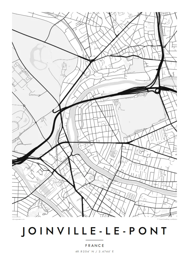
The river sweeps around the town in a broad curve, and its long islands and side channels draw a double line of water that stands out clearly in black and white.
Minimalist map poster · France
48.8254° N / 2.4746° E
A riverside suburb folded into a bend of the Marne, with wooded parkland to the north and islands resting mid-channel
One city, five moods
Tap a style to see it on the wall. Every style costs the same — printed, framed or as HD files.
 Actual pixels · 24 × 36″ print file
Print-sharp
This is a 100% crop of the real print file. Every poster — printed, framed or downloaded — is rendered on our servers at 300 DPI, up to 7,200 × 10,800 pixels, so even the smallest lanes stay crisp on a 24 × 36″ print.
On the wall


The map
Joinville-le-Pont sits just southeast of Paris, where the Marne makes one of its loops before joining the Seine. From above, the river is the defining stroke. It curves along the town's edge, and slim islands split the current into parallel channels. On the far side, the neighbourhoods of the next communes continue the same fine-grained street pattern.
The town takes its name from its bridge, and a crossing has stood here for centuries. In the twentieth century Joinville became known for its film studios, where a good share of French cinema was shot. The riverbanks were also known for the guinguettes, open-air dance halls where Parisians came on weekends to eat, dance and row on the water.
A Joinville-le-Pont map poster shows how tightly the town is framed. The dense greenery of the Bois de Vincennes lies to the north, the Marne wraps around the south and east, and rail and road lines cut across in between. The result is a compact, legible composition in which water, woodland and streets each take up a clear share of the sheet.
The river sweeps around the town in a broad curve, and its long islands and side channels draw a double line of water that stands out clearly in black and white.
To the north, the open mass of the Bois de Vincennes meets the street grid. It gives the map a large calm field that balances the busier residential blocks.
The crossing that gave the town its name ties both banks together, and roads converge on it from several directions like spokes.
Make it yours
Add a date, a name or a line of your own, switch style, size or orientation.
The free preview is low-resolution with a watermark. Prints and HD files are rendered at 300 DPI, up to 7,200 × 10,800 px, without a watermark.
Why Joinville-le-Pont
For people who grew up by the Marne or spent summer evenings along its banks, this map brings back a very specific landscape: water, trees and the short trip out from Paris. It suits a hallway or a study, where the river's curve reads well from across the room.
You can add your own title, subtitle and coordinates line, perhaps a street name or the year you moved in. Then pick one of five styles: Classic black & white, Noir, Paper, Blueprint or Sand. The digital files cost $9, and printed posters are also available.
Order the Joinville-le-Pont poster| Print size | Resolution | Files |
|---|---|---|
| 30 × 40 cm11.8 × 15.7″ | 3,543 × 4,724 px | PNG · PDF |
| 29.7 × 42 cm (A3)11.7 × 16.5″ | 3,508 × 4,961 px | PNG · PDF |
| 42 × 59.4 cm (A2)16.5 × 23.4″ | 4,961 × 7,016 px | PNG · PDF |
| 45.7 × 61 cm18 × 24″ | 5,400 × 7,200 px | PNG · PDF |
| 50 × 70 cm19.7 × 27.6″ | 5,906 × 8,268 px | PNG · PDF |
| 61 × 91.4 cm24 × 36″ | 7,200 × 10,800 px | PNG · PDF |
For comparison, the free preview is 900 px wide, watermarked and meant for screens. The HD files have up to 8× the resolution in each direction and print cleanly at full poster size.
Pick a style at the top of the page, then choose Printed Poster — a size and, if you like, a frame — or Digital HD Files. Checkout takes one step, and your order page updates as soon as the payment goes through.
It is printed on premium 200 gsm matte paper in one of six sizes, from 30 × 40 cm to 24 × 36″. Printed posters start at $39, shipping included.
Yes. Choose a solid wood frame in black, white, natural oak or dark wood. It comes with shatterproof glazing and is ready to hang. Framed posters start at $99, shipping included.
Shipping is free to 60+ countries. Each poster is printed by the nearest of our print partners in 30+ countries and usually arrives in 3–7 business days. You can follow the status and tracking under My Orders. A few countries take 2–5 weeks, and where we don't ship yet, the site tells you before you pay.
Send us a photo within 14 days of delivery and we will reprint it for free or refund you.
Yes. In the editor on this page, change the title, the subtitle and the coordinates line to anything you like, and pick a style and size. Printed, framed and digital orders all use exactly your design.
For $9 you get 300 DPI PNG and print-ready PDF files in all six sizes, without a watermark, to print anywhere. Not sure yet? Download a free watermarked preview first.
Nearby
